Union Island, St Vincent an the Grenadines, where 98% of buildings were reportedly destroyed. Photo: Tony Giles, MapAction.
MapAction needs new funding to respond to the estimated scale of global disasters in 2024, particularly in the Caribbean – where Hurricane Beryl is already wreaking devastation – and Asia.
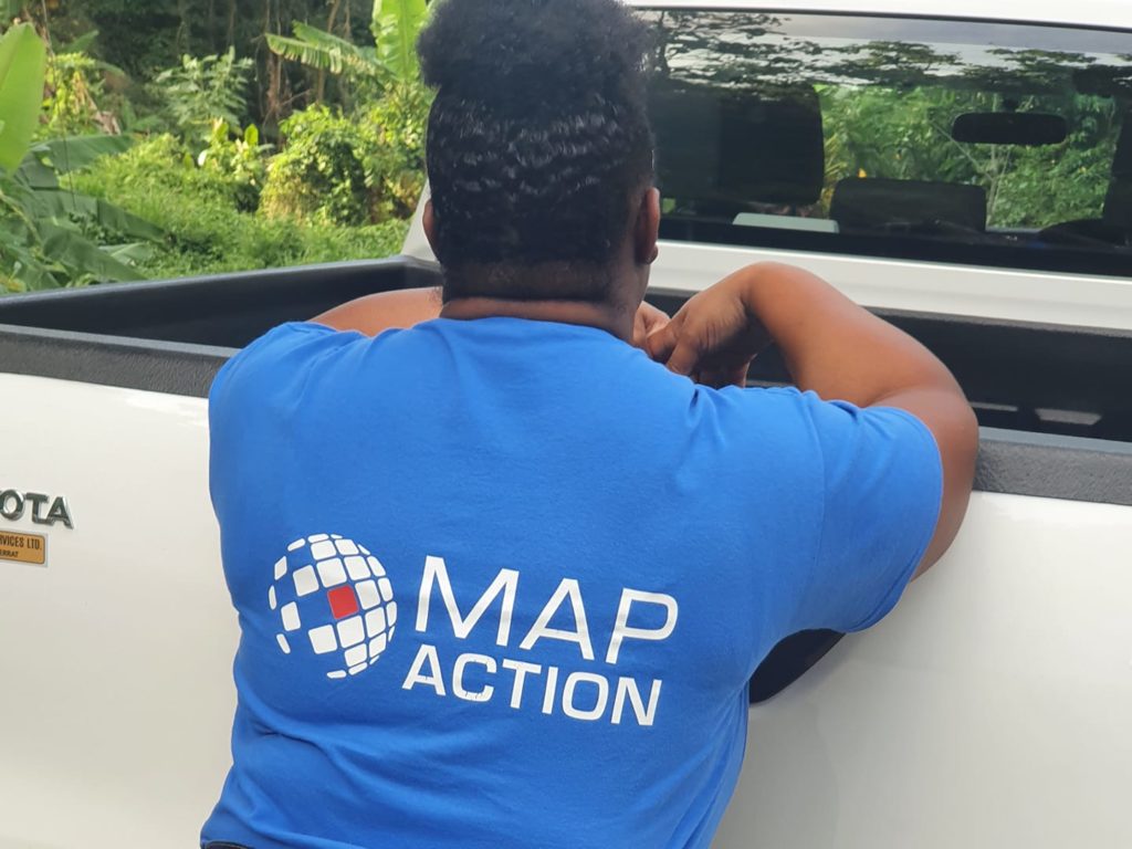
Hurricane Beryl continues to leave devastation throughout the Caribbean. As information floods in, agencies like the Caribbean Disaster Emergency Management Agency (CDEMA), that is coordinating the response, need to understand the data coming from more than a dozen affected islands. MapAction members are on the ground supporting them by making maps: which communities are worst affected; where are emergency shelters, which roads and critical infrastructure have been damaged. These are just some of the key data points that MapAction’s team quickly maps to ensure support and aid goes where it is most needed.
“CDEMA and MapAction have been working together for many years responding to disasters while learning to be able to better respond to future disasters. When an event like Hurricane Beryl happens, CDEMA makes the call to MapAction because they will deploy specialist teams that understand what we need, and can make an immediate impact on how CDEMA and its regional and international partners provide aid to disaster affected countries.”
Carriacou, Grenada, after Hurricane Beryl. Photo: Lavern Ryan, MapAction.
Maps help decision-makers to save lives when disasters strike. Risk and impact can quickly be assessed; aid and support sent to where it is most needed. But deploying teams from our team of 70+ experienced humanitarian mappers costs money. We have been able to deploy teams so far to Grenada and St Vincent and the Grenadines thanks to support from the German Federal Foreign Office’s Fund for Humanitarian Assistance. We need more for future responses, in what is predicted to be an exceptional hurricane season.
Nobody can predict the exact number of disasters where our help will be requested. What we know is that the climate emergency is driving an increase in the number of natural disasters; hurricanes, typhoons, floods, droughts, conflict and much more. We are limited in the requests we can respond to.
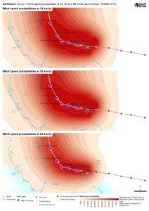
Hurricane Beryl leaves near total-destruction in one Caribbean island before striking Jamaica on July 4th, Mexico on July 5th, 6th and 7th. Struck coast of US on July 8th: seven reported casualties (18 total for Hurricane Beryl, July 9th)
80,000 people affected and 60,000 people in need of humanitarian assistance on devastated islands in Grenada and St Vincent and the Grenadines (July 10th, UN)
US death toll: 36 (Media reports, July 29th) 11 casualties already from Hurricane Beryl in the Caribbean, according to July 8th media reports
Caribbean death toll: AT LEAST 11 (Media reports)
Thousands of people in Grenada and St Vincent and the Grenadines still in shelters
98% of housing on Union Island, in St Vincent and the Grenadines, destroyed (ReliefWeb, July 3rd)
St Vincent and the Grenadines and Grenada worst affected, although damage in Jamaica and Cayman Islands too
Hurricane Beryl is the first major hurricane of the 2024 Atlantic hurricane season. It is already the strongest July hurricane on record.
“Hurricane Beryl impacted several countries in the southwestern Caribbean. CDEMA continues coordinating the response efforts, supported by National Emergency Management Coordinators. Various forms of support are being provided to St. Vincent and the Grenadines, Grenada, and its dependents. Assessments have commenced to determine the response level. Additionally, a Level 1 response is ongoing in Barbados, Trinidad and Tobago, Saint Lucia, and Dominica.” Relief Web (July 2nd).
For specific map and data products, please also check our data and maps repository: maps.mapaction.org.
Find out more about MapActions’ previous 140+ emergency response support missions here.
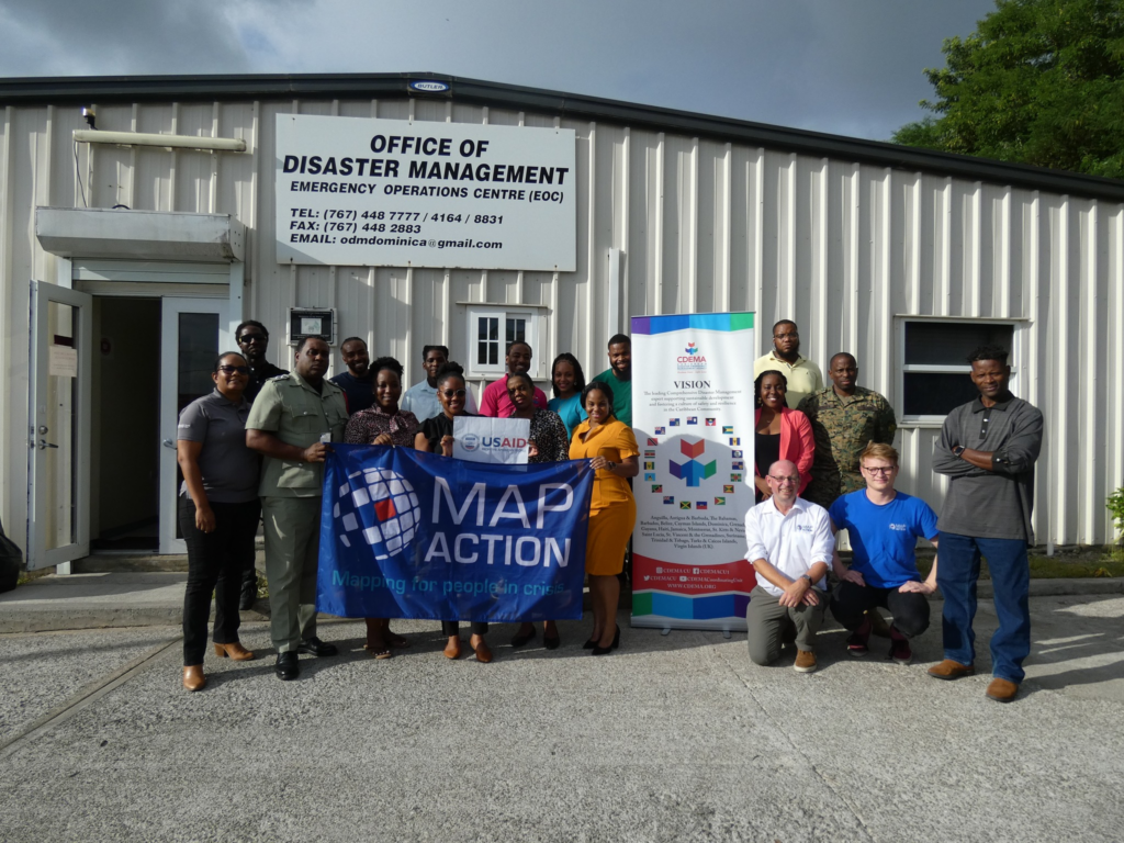
The response is being coordinated by the Caribbean Disaster Emergency Management Agency (CDEMA). MapAction and CDEMA have been partners for more than 15 years. Find out more about the partnership in this podcast.
MapAction humanitarian mappers are in the Caribbean to support CDEMA response
Want to know more about MapAction’s work? This short video gives an overview of what we do.
*This blog is not regularly updated in the evenings or on weekends
Hurricane Beryl updates
July 29th, 11:00 UTC: This Hurricane Beryl blog will no longer regularly be updated.
Thank you so much for following this blog in the last couple of weeks. It’ll be reactivated with regular updates when the next hurricane in this ‘hurricane season’ occurs. We leave you with another map for now.
The map outlines damage to schools on the Grenadines.
July 29th, 11:00 UTC: Clean up and post-Hurricane Beryl response still in full swing
“Ongoing clean-up efforts in Grenada and Saint Vincent and the Grenadines are focused on managing debris, restoring essential services, and mitigating health risks. Both countries face logistical challenges and need urgent clean-up due to improper waste management and fuel contamination.,” states a July 26th update on Relief Web from UN OCHA. “Union Island in Saint Vincent and the Grenadines urgently needs water, food, and housing materials, with protection issues requiring specialized attention. Telecommunication problems and depleted supplies hinder response efforts. In Carriacou, Grenada, teams are supporting assessments with the National Disaster Management Agency (NaDMA). Local staff are being trained to take over operations, as concerns about volunteer burnout highlight the need for long-term staffing solutions,” adds the update. Read the full release here.
July 17th, 12:50 UTC: Map of humanitarian deliveries helps identify need for future vital aid
This map of post-Hurricane Beryl humanitarian relief deliveries on Carriacou and Petite Martinique, both in Grenada, helps humanitarian agencies understand which communities have already received basics like food and water and which communities are most in-need for future deliveries.
July 16th, 14:40 UTC: Map of structural damage in Grenada highlights severity and access
This map of structural damage in southeast Grenada helps decision-makers and emergency responders, like MapAction partner the Caribbean Disaster Emergency Management Agency (CDEMA), focus their resources and time during a response on the most at-risk communities. The map colour codes areas with particularly high levels of damage, while also highlighting human settlements nearby, as well as main and secondary roads to illustrate access.
Providing the insights and maps that help decision-makers respond more effectively to emergencies, like Hurricane Beryl, is expensive. If we are to continue to respond to future emergencies in what is expected to be a busy ‘hurricane season’, we need your support. Can you or somebody you know support our appeal?
July 15th, 16:45 UTC: Where MapAction goes, the tech trunk follows
July 15th, 16:45 UTC: MapAction mapping Lavern Ryan to continue to support CDEMA from Barbados office
MapAction member Lavern Ryan (right) was today airlifted from Carriacou to Grenada, before travelling to Barbados where she will continue to work with the Caribbean Disaster Emergency Management Agency (CDEMA) on the response to Hurricane Beryl. She travelled with CDEMA’s Executive Director Elizabeth Riley (centre) and Caribbean Public Health Agency (CARPHA) Interim Executive Director Dr. Lisa Indar.
July 15th, 16:30 UTC: Jamaica maps combine key access routes and population data at parish level
These four parish maps from Jamaica help decision-makers understand the baseline population in each parish, as well as basic access by road or railway. This helps those planning the recovery after Hurricane Beryl to zone in to specific affected parishes and plan tailored responses for those areas.
July 15th, 08:55 UTC: Hurricane Beryl affected 10 CDEMA member states. Focus now on Grenada, St Vincent and the Grenadines, Jamaica and Cayman Islands to inform “early recovery actions” (CDEMA)
“Hurricane Beryl has moved out of the area and is no longer a threat to Caribbean States that are a part of the Caribbean Disaster Emergency Management (CDEMA) System. Following the passage of Beryl and its impact on ten (10)Participating States, the focus is now on assisting Grenada and its Grenadines of Carriacou and Petite Martinique, and the Grenadine islands of Bequia, Union Island, Canouan and Mayreau in St. Vincent. Assessments continue in Jamaica and the Cayman Islands to determine damage and inform response and early recovery actions.” Read the full July 12th update from the Caribbean Disaster Emergency Management Agency (CDEMA) here.
July 11th, 14:25 UTC: MapAction team in Jamaica produce set of baseline maps
Experienced humanitarian mappers Alistair Wilkie and Kirsty Ferris are in Jamaica working with the United Nations Disaster Assessment Coordination (UNDAC) team in Kingston on situation maps (e.g. locations of shelters), assessment maps (e.g. damage to critical infrastructure) and population products.
July 11th, 11:30 UTC: Map of impassable roads in Carriacou, Grenada, designed to help humanitarian agencies deliver aid, and evacuate at-risk communities to shelters, more efficiently
The map below, made by our team working on Grenada, shows which roads have been made impassable by Hurricane Beryl on the island of Carriacou. This helps needs assessment teams to identify the fastest route to deliver humanitarian aid and the easiest way to evacuate people to shelters, while adding to the overall assessment on damage to core infrastructure.
July 11th, 09:30 UTC: IOM has 51 emergency shelters in Jamaica
The MapAction map below, made by our team on the ground in Jamaica, outlines the location of more than 50 emergency shelters established by the International Organisation for Migration (IOM) in response to Hurricane Beryl.
July 11th, 08:15 UTC: 80,000 people affected in Grenada and St Vincent and the Grenadines
“Over 80,000 people were potentially affected by Hurricane Beryl across Grenada and Saint Vincent and the Grenadines, including more than 44,000 in Grenada, and 40,000 people in Saint Vincent and the Grenadines, based on the number of people hit by wind speeds of 120 km/h or above, according to the Pacific Disaster Center (PDC Global). The number of people in need of humanitarian assistance is estimated to be nearly 60,000 people.” July 10th statement from the United Nations Office for the Coordination of Humanitarian Affairs (UN OCHA).
July 10th, 10:00 UTC: More photos of devastation from Carriacou, Grenada
Photo: Lavern Ryan.
Photo: Lavern Ryan.
MapAction deployed mapper Lavern Ryan on Carriacou with the coastguard. Photo: Lavern Ryan.
July 10th, 09:15 UTC: Nearly 1000 people remain in shelters in St Vincent and the Grenadines
12,000 people are estimated to be in need of basic services, including 3,500 children, between Grenada and St Vincent and the Grenadines as of July 10th, according to the latest update from the United Nations Office for the Coordination of Humanitarian Affairs (UN OCHA).
July 9th, 14:45 UTC: Needs assessment with CDEMA continues
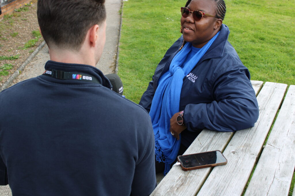
MapAction members Tony Giles and Elena Field talk about the current situation on St Vincent and the Grenadines with Elizabeth Riley (3rd from right), executive director of the Caribbean Disaster Emergency Management Agency (CDEMA) as they cross paths in transit at the airport.
July 9th, 13:05 UTC: WFP delivers emergency food to St Vincent and the Grenadinesto feed 4500 people for 10 days
WFP offloaded 1,500 ready to eat kits to feed 4,500 people for 10 days and an interagency shipment of supplies arrived in St. Vincent and the Grenadines. @wfp_Caribbean & @cdemacu are united to provide relief & support to countries impacted by #HurricaneBeryl. pic.twitter.com/9qNKwzkG7w
If you haven’t seen our appeal to be able to continue to respond and provide vital map and data support to regional agencies in the Caribbean during this ‘hurricane season’, please see it below. Do you know a friend, contact or company that could help? Get in touch!
“CDEMA and MapAction have been working together for many years responding to disasters while learning to be able to better respond to future disasters. When an event like Hurricane Beryl happens, CDEMA makes the call to MapAction because they will deploy specialist teams that understand what we need, and can make an immediate impact on how CDEMA and its regional and international partners provide aid to disaster affected countries.”
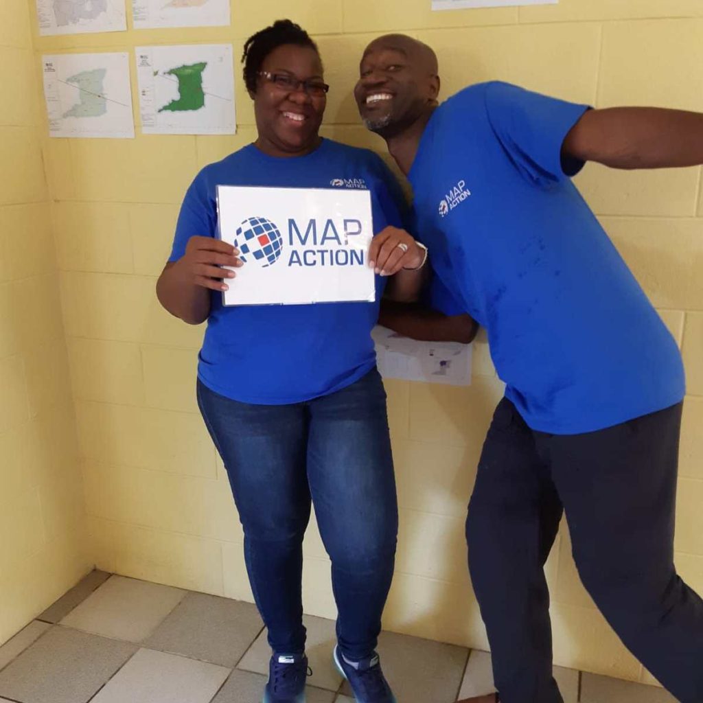
July 9th, 10: 50 UTC: Meet Lavern Ryan, who is in the Grenadine Islands supporting CDEMA with mapping
Lavern Ryan in Carriacou after Hurricane Beryl.
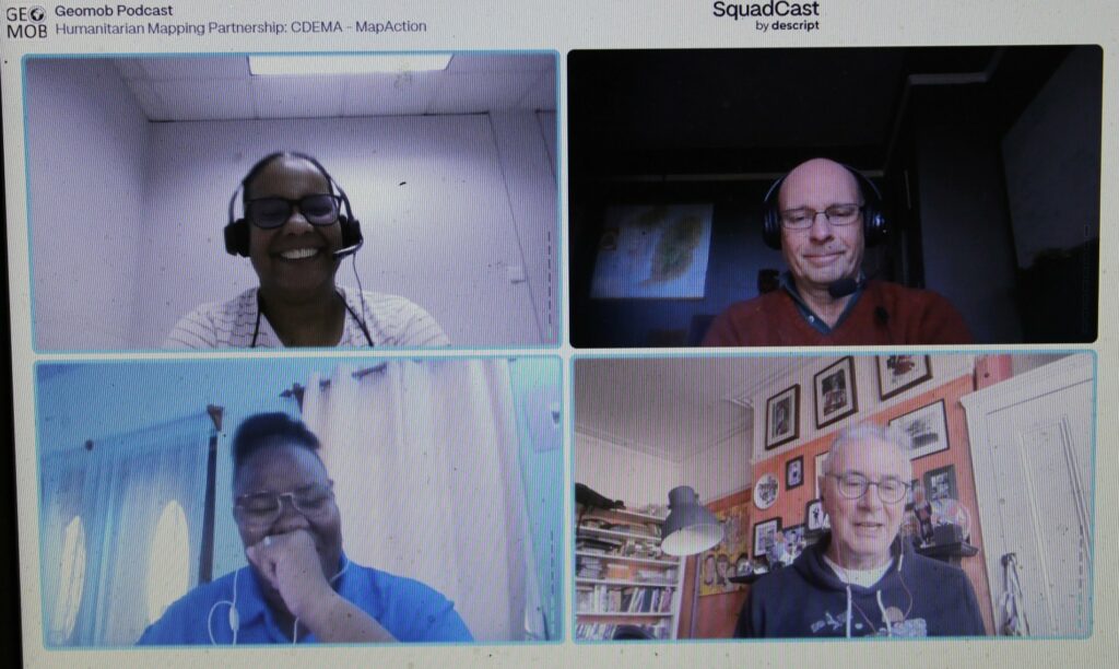
Lavern, from Montserrat, told her own personal story of displacement following a volcanic eruption on her home island in 1996 on our podcast with Geomob. We also featured Lavern this year on International Women’s Day.
“To make sense of the immense amount of data in today’s world, we can map it.” Still wondering what geospatial means and why we map things? This explainer scroll from ESRI does a good job for anyone curious to learn more about this use of technology.
July 9th, 08: 15 UTC: MapAction ‘Map Wall’ is a compass in a crisis
MapAction ‘Map Walls’ give decision-makers a holistic overview of key data in a crisis. Below, MapAction mapper Elena Field showcases the most recent iteration of the map wall for Hurricane Beryl. The wall covers the basics: what is the population in each part district and who is affected? Where are the emergency shelters and working health facilities? What damage has been incurred to buildings and key infrastructure?
July 9th, 08:15 UTC: Nearly 1000 people in 41 temporary shelters on St Vincent
The MapAction map below shows where the shelters are on St Vincent and what the occupancy breakdown is by adults and children. This helps organisations focused on child health to offer tailored, additional support to children displaced by the hurricane.
July 9th, 08:05 UTC: Seven reported casualties in the US
Seven people have lost their life in the US to Hurricane Beryl, reports the BBC. Nearly three million people in Texas and Louisiana were without power last night.
July 8th, 15:15 UTC: Satellite image of Union Island helps needs assessment team inspect and verify damaged buildings
MapAction would like to acknowledge the support of imagery company BlackSky, who allowed us to task their satellite and source remote imagery of the affected islands as part of data for the map below.
Post event imagery allows decision-makers to see which buildings have sustained damage. The actual imagery has a ground resolution of one metre which allows for inspection, verification and planning. This helps those making decisions to quickly understand which buildings have been destroyed and where. #geospatial4good
Union Island. Photo: Tony Giles
July 8th, 14: 25 UTC: Jamaica: 2 deaths, 250 roads blocked and 1800 people in shelters
The latest bulletin on Hurricane Beryl’s damage to Jamaica as it passed through the island on July 3rd from the United Nations Office for the Coordination of Humanitarian Affairs (UN OCHA).
There was extensive damage to utility poles and downed powerlines across parishes. Impacts across the island also included Fallen Trees, Wind damage to infrastructure and roofing, Flooding and Storm Surges.
July 8th, 13:50 UTC: Podcast: “I don’t know if it is because we are perfectly or imperfectly positioned”
Earlier this year, the folks from Geomob, in a co-production with MapAction, sat down to discuss the Caribbean with CDEMA’s GIS Specialist Renée Babb and Montserratian MapAction volunteer Lavern Ryan. You can listen to the podcast here. Below is an excerpt from CDEMA’s Renée Babb on why the Caribbean is so prone to natural disasters.
July 8th, 13:25 UTC: MapAction publishes 3D visualisation of affected islands
A 3D fly-through of the Grenadine Islands of Union, Mayreua and Canouan. Imagery Credits: Esri, Maxar, Earthstar Geographics, and the GIS User Community
July 8th, 09:10 UTC: CDEMA deep into response and rapid assessment in St Vincent
Video of the Caribbean Disaster Emergency Management Agency (CDEMA) in action as their Rapid Needs Assessment Team (RNAT) works in St Vincent and the Grenadines. 98% per cent of infrastructure and housing on Union Island was reportedly destroyed by Hurricane Beryl. Rasheed Pinder, CDEMA’s programme officer, outlines the response so far. Video courtesy of CDEMA and CBC TV 8.
Video courtesy of CDEMA.
July 8th, 08:15 UTC: MapAction team in St Vincent to provide support to CDEMA Rapid Needs Assessment Team (RNAT)
MapAction members (centre) with the CDEMA Rapid Needs Assessment Team (RNAT) in St Vincent over the weekend. Photo: CDEMA.
July 8th, 08:10 UTC: Hurricane Beryl strengthening again to Category 2 hurricane as it approaches Houston, USA.
The storm left devastation in several Caribbean islands last week, causing 11 deaths. Mexico was impacted by storms and strong winds over the weekends, reports Reuters.
July 5th, 09:45 UTC: IFRC: “New reality for the Caribbean”
“This unprecedented early-season hurricane underscores the new reality of the climate crises that Caribbean small island nations face: storms are more likely to rapidly intensify and become stronger, causing severe destruction and giving communities less time to recover in between shocks. The hotter-than-normal water temperatures in the southern Atlantic and Caribbean are acting as fuel for storms, causing them to intensify very quickly into major hurricanes –category three or superior.” More in a statement on Hurricane Beryl from the International Federation of the Red Cross (IFRC).
July 5th, 08:25 UTC: Coast of Mexico (Playa del Carmen, Tulum and Cancún), hit by strong winds and heavy rains
Reportan intensas lluvias y fuertes ráfagas de viento en Playa del Carmen, Tulum y Cancún, Quintana Roo, por el ingreso del huracán #Beryl a México. #HurricaneBerylpic.twitter.com/r0BHeYeQQe
July 4th, 19:35 UTC: Cayman Islands avoid the worst from Hurricane Beryl
Despite reported damage to building and infrastructure, the government of the Cayman Islands has issued an all-clear statement, meaning Hurricane Beryl did not wreak the havoc expected there.
July 4th, 19:30 UTC: MapAction members en-route to St Vincent
July 4th, 14:25 UTC: Cayman Islands, Yucatan Peninsula, Belize, Mexico and USA could still be affected by Hurricane Beryl
An update on the projected path of Hurricane Beryl from the National Hurricane Center and the Central Pacific Hurricane Center states that the Cayman Islands, Belize, Mexico and areas of the USA can expect strong winds and storms caused by the hurricane in the coming days.
July 4th, 12:15 UTC: Satellite images show the extent of the damage to homes and infrastructure caused by Hurricane Beryl as it surged through the Windward Islands
Newly released high-resolution satellite images give a sense of just how devastating Hurricane Beryl was to parts of the Windward Islands.
— St. Lucia Government (@SaintLuciaGov) July 2, 2024
July 4th, 12:06 UTC: Cayman Islands braced for Hurricane Beryl
“Residents of the Cayman Islands should prepare for worsening conditions as Hurricane Beryl continues to approach. The storm’s current trajectory brings it dangerously close to the islands, with the potential for significant impacts,” states the latest July 4th update from the Cayman Islands government.
July 4th, 10:05 UTC: Hurricane Beryl moves on from Jamaica having caused further devastation
BULLETIN No: 21 *** HURRICANE WARNING DISCONTINUED *** FLASH FLOOD WATCH NOW IN EFFECT FOR THE ISLAND pic.twitter.com/IDy26A5KlU
July 4th, 10:00 UTC:11 emergency shelters operating in Grenada, according to the national disaster management agency (NaDMA)
July 4th, 09:15 UTC: Up to 3 million children at risk, says UNICEF
The winds, torrential rains and flash flooding could put at least 3 million children in the Caribbean at risk, according to UNICEF estimates released yesterday.
“UNICEF and partners have pre-positioned life-saving supplies in several countries in the Caribbean Basin, including medical kits, educational kits, essential water supplies, sanitation and hygiene materials (such as water tanks, large bottles and water purification tablets), and key equipment such as high-quality tents, which will be deployed as needed,” adds the release on ReliefWeb.
July 4th, 08:00 UTC: Union Island suffers “near-total devastation”as Hurricane Beryl strikes Jamaica
“Carriacou and Petit Martinique, part of Grenada, saw most buildings, including schools and petrol stations, damaged or destroyed,” states an update from ReliefWeb on July 3rd. “Union Island, part of St. Vincent and the Grenadines, suffered near-total devastation, with 98% of housing destroyed, no sanitation facilities, limited water, and extensive damage to its airport and power plant. Evacuations to St. Vincent are ongoing despite limited accommodation due to the Vincy Mas carnival.”
July 3rd, 18:55 UTC: MapAction deployment scale-up planned
Following meetings today with both the Caribbean Dissaster Emergency Management Agency (CDEMA) and the United Nations Office for the Coordination of Humanitarian Affairs (OCHA), as well as the United Nations Disaster Assessment Coordination Office (UNDAC), it is extremely likely that MapAction’s response to Hurricane Beryl will be scaled up and potentially last until the middle of August (if resources allow).
A team of three humanitarian MapAction mappers is in Barbados with CDEMA. Onward deployment to Grenada and St Vincent & the Grenadines is expected.
UNDAC are also planning to deploy a team to Jamaica as they are expecting significant damage and humanitarian impact there. MapAction are planning to support this UNDAC response with two further MapAction members. This would be an initial two week deployment, starting as early as this weekend.
July 3rd, 17:00 UTC: Remote team of mappers supporting CDEMA
A team of three experienced MapAction mappers is providing 24-hour remote support to CDEMA. See some of the maps published below.
Published Maps – MapAction have already published a growing range of downloadable baseline and reference maps for Grenada, The Grenadines & St Vincent, and now Jamaica. These cover Critical Infrastructure, Emergency Shelters, Baseline Population and Country Overview Maps. They can be found on our website at mapaction.maps.org, as well as on ReliefWeb. Due to some sporadic technical issues with our system all maps are currently also being uploaded to the Virtual OSOCC.
What exactly does MapAction do? Find out more in the short video below
July 3rd, 10.45 UTC: MapAction to support CDEMA in response
Three expert MapAction mapping and information management volunteers are en-route to Barbados, in response to Hurricane Beryl. Two have left the UK and they will be joined in Barbados by a third, from Montserrat. From Barbados they will coordinate with the response team at long term MapAction partners, CDEMA (Caribbean Disaster Emergency Management Agency).
Hurricane Beryl rapidly intensified over the weekend to become the first major hurricane of the 2024 Atlantic hurricane season. It made landfall on Carriacou Island in Grenada, on July 1st as a Category 4/5 hurricane, bringing damaging winds, heavy rain, and a storm surge. Beryl has already caused significant damage and loss of life in Cariacou, St Vincent and The Grenadines, and Venezuela, and is already the strongest July hurricane on record.
Beryl is projected to travel through the central Caribbean, buffeting Haiti, before potentially impacting Jamaica and the Cayman Islands, before entering the Gulf of Mexico, approaching the Yucatan Peninsula later in the week, remaining a major hurricane throughout.
MapAction was initially contacted by CDEMA on Sunday June 30th, and the team was ready to deploy within 24 hours. Meanwhile MapAction also has three further team members supporting remotely, offering 24 hour support as they are respectively currently situated in Taiwan, Colombia and the UK. Further team members are standing by. CDEMA will be liaising with both national governments and with UN Regional Office for Latin America and Caribbean, with whom MapAction also has a long record of support.
We believe this will be a large multi-country response, drawing significantly on both emergency response personnel availability and cash resources.
MapAction will also be launching an appeal, to ensure that we can immediately and effectively respond to Hurricane Beryl, and to hurricanes and crises later in the year. If you value MapAction’s work, please make a donation. Even when it is provided by MapAction’s expert volunteers, providing this vital support costs money.
Further updates will follow as this response develops.
MapAction team members are supporting the Belize national disaster management agency NEMO to get a clearer understanding of the extent and impact of wildfires that continue to spread through southern and western Belize, causing damage to infrastructure, crops, land and livelihoods.
MapAction’s Edith Lendak works with Director of Toledo District Indigenous Peoples’ Affairs Gustavo Requena (right) and NEMO GIS Officer Luwin Tzib (left) to confirm the location of local community settlements in fire-impacted districts. Photo: MapAction
Drought and a lack of rainfall have caused severe ongoing wildfires in the Central American country of Belize. As of May 28th, 10,000 hectares of land and 200 homes had been destroyed, according to the Caribbean Disaster Emergency Management Agency (CDEMA). Damages as of end of May 2024 totalled more than $8 million.
The response to the wildfires is being coordinated by Belize’s national disaster response agency, the National Emergency Management Organisation (NEMO), one of 19 CDEMA members. CDEMA, a long-time MapAction partner, requested MapAction’s support to assist local authorities in getting a clearer understanding as to the extent of the crisis.
MapAction volunteer members Sam Gandhi, a GIS specialist, and Edith Lendak – who works for green energy company Orsted – are in Belize assisting the Geospatial Information Systems (GIS) and disaster assessment teams out of the National Emergency Management Organisation’s (NEMO) various country offices. MapAction volunteer member Indigo Brownhall, a researcher with the Space Geodesy and Navigation Laboratory (SGNL) at University College London (UCL), is providing remote support.
MaAction volunteer member Sam Gandhi.
The team’s focus will be on the worst affected areas: the southern region of Toledo, before moving north to focus on Cayo District, where the country’s capital, Belmopan, is situated.
“This shows the effectiveness of our partnership with CDEMA,” says Darren Dovey, head of emergency response for MapAction. “We were able to quickly understand their needs and advise that sending a MapAction team to Belize would be the most effective way to support them, working with their own GIS teams and supported by the wider MapAction membership remotely,” adds Dovey.
Head of Emergency Response Darren Dovey.
The maps produced so far cover a range of key data points: the baseline population in each district, disaggregated by age, sex and gender; key ecosystems of Belize, as well as landcover per area. More maps will be created for decision-makers in the next few days and weeks.
MapAction helps decision-makers get an overview of an emergency by mapping the key data about the extent and impact on communities, land and infrastructure. This helps emergency responders act faster, more efficiently and provide support to at-risk communities.
Each map is created to help decision-makers act faster and more accurately. Some maps are key to search-and-rescue operations – knowing where to send rescue personnel, which areas have been searched and which have not. Other maps might help plot a path for emergency aid to those who need it most, using the fastest and most accessible routes. Another map might outline where people are moving; how a wildfire is spreading or where the largest human need is.
She survived a volcanic eruption and helped rebuild her island afterwards. Meet Lavern Ryan, a MapAction volunteer and GIS aficionado.
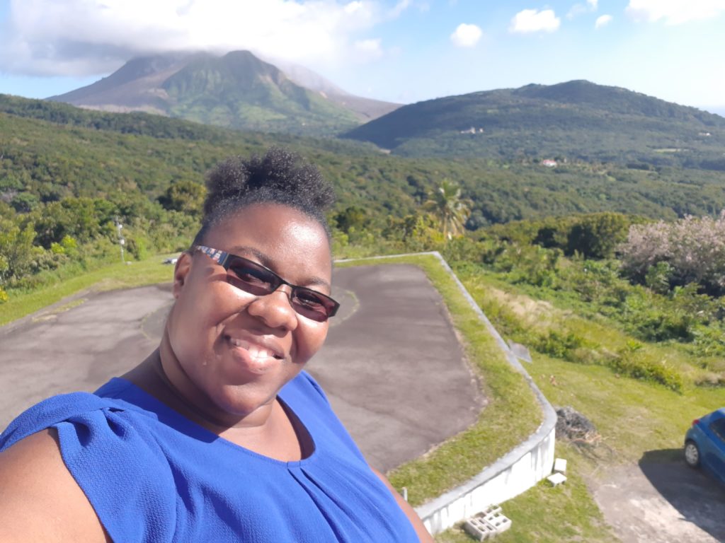
Lavern Ryan in Cottesmore, UK, for HEAT training. Photo: Lavern Ryan
‘Be the change that you want to see in the world’ is a quote often attributed to Mahatma Gandhi but on International Women’s Day 2024, MapAction volunteer Lavern Ryan says it captures her thoughts. “I would like to encourage women and girls worldwide to do just the same. Whatever one sets their mind to, it can be accomplished with strength, determination and prayer,” she adds.
Lavern is the living proof of her own words; her story reads like a triumph of willpower over circumstances. In 1995, Lavern was displaced from her home island of Montserrat due to a volcanic eruption.
Displaced by volcano
“I remember it like it was yesterday although it was 28 years ago,” Lavern recalled recently in a podcast with GeoMob. Lavern went on to recollect how many people on the Caribbean island of Montserrat tried to head north amidst the “chaos and panic” to get away from the erupting Soufriere Hills volcano. The current population of Montserrat is approximately 5000 people.
Lavern first moved to Antigua, the closest island to Montserrat, but found misfortune to have travelled with her. In September 1995, the Category 4 Hurricane Luis struck Antigua, meaning Lavern had now experienced two major natural disasters within three months. Lavern was 13 at the time. She went on to complete her secondary school education in Antigua and then a Bachelor’s Degree in Computer Science in Trinidad and Tobago. She later also studied at Edinburgh University and the University of Dundee in Scotland.
GIS to the rescue
When Lavern did return to Montserrat a few years later, the southern part of the island – still inaccessible today – was covered in pyroclastic flows. Her newfound skills in GIS and remote sensing were serendipitous however, “to identify where the best places were to occupy the northern part of the island.” Timely work as the volcano has continued to erupt since 1995, making half of the island uninhabitable.
Since 2002, Lavern has been the GIS Manager for the Government of Montserrat. She works closely with the Island’s disaster management authorities and cares for a broad portfolio: from leading hydrographic surveys and conducting aerial drone mapping to training the next generation of enthusiastic humanitarian mappers on the island.
“I really admire Lavern’s attitude to her life and work,” says MapAction’s Alan Mills, who has worked with Lavern for many years. “She not only juggles all her government duties on Montserrat with her priorities to her family and friends, she still has time to advocate across her community, kids and adults alike, of the importance of maps and geoinformation in everyone’s lives and apply all those skills with energy to spare.”
So what has Lavern’s work entailed most recently? “The capturing and processing of drone aerial images in Montserrat was an important aspect which helped with the successful implementation of enumeration for the 2024 Montserrat population and housing census,” Lavern told the MapAction communications team.
Despite having more than 20 years GIS experience under her belt, Lavern continues to refresh and broaden her skillset. During a recent visit to the UK, Lavern attended courses, training and talks at key institutes.
At the UK Hydrographic Office in Taunton, Lavern had the opportunity to meet with other UK Overseas Territory delegates and engaged in discussions on hydrographic action plans, governance and marine spatial planning. There was also a focus on the need to upskill her use of software to conduct hydrographic surveys as part of Montserrat’s commitment to the International Convention on Safety of Lives At Sea (SOLAS). “This helps us to fulfil our international safety obligations,” says Lavern, the technical lead for conducting hydrographic surveys on the island of Montserrat.
“I also visited the Joint Nature Conservation Committee (JNCC) offices in Peterborough,” adds Lavern. “My focus there was to wrap up a project we were working on with respect to storm surge modelling.”
Lavern also managed to squeeze in a refresher security course, a prerequisite for all MapAction volunteers who deploy. Lavern began to volunteer with MapAction in 2019 and has been involved in several remote responses to natural disasters in the Caribbean since 2020. She expects to be involved in more this year, often together with the Caribbean Disaster Emergency Management Agency (CDEMA). After all, the Caribbean has its own season, she told GeoMob: “Hurricane Season,” from June to November each year. Her skillset will forever be needed.
Renee Babb, GIS specialist with the Caribbean Disaster and Emergency Management Agency (CDEMA) – a longterm MapAction partner – and Lavern Ryan, a GIS specialist with the government of Montserrat and also a MapAction volunteer, talk with MapAction’s Alan Mills MBE on the GeoMob podcast about CDEMA and MapAction’s decade-long relationship.
Find out why they say there is a fifth season in the Caribbean: “Hurricane Season.”
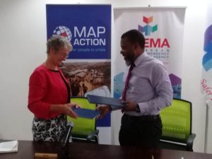
MapAction’s collaboration with CDEMA and its participating countries through training and building capacity, enables better integration of geospatial technologies into disaster risk management.
The new MOU will support CDEMA’s capacity to provide geospatial expertise to its deployment teams, allow for GIS training across participating states and provide geospatial mapping and technical support upon request.
Executive Director of CDEMA Elizabeth Riley stated, “The renewal of our MOU supports our vision of a digitally transformed CDEMA, essential to positioning CDEMA for the future. We are committed to the integration of digital technology into all areas of CDEMA’s operations and we thank MapAction for supporting us on this journey.”
Climate change and it’s growing impact in the Caribbean is well documented. Liz Hughes CEO, MapAction said, “We know the Caribbean region suffers particularly from extreme weather conditions as a result of climate related changes around the world and we recognise that we will all need to work together to support CDEMA in the challenging role of leadership through this. This past year alone, we have done just that on the St Vincent and Grenadines, Suriname and Guyana emergencies demonstrating the possibilities of remote support even where emergencies have become increasingly complex.”
Recently MapAction has worked with CDEMA to implement a successful simulation exercise, undertake training courses and create a multi-faceted virtual platform that hosts risk management data and information that’s accessible to stakeholders to facilitate analysis, research, greater awareness of risk management and climate change adaptation in the region.
We look forward to the opportunity to learn from CDEMA and share the experience, knowledge and skills in the region to partners worldwide.
This work was made possible thanks to the generous support of the U.S. Agency for International Development Bureau for Humanitarian Affairs as part of a programme to improve cooperation in the humanitarian sector.
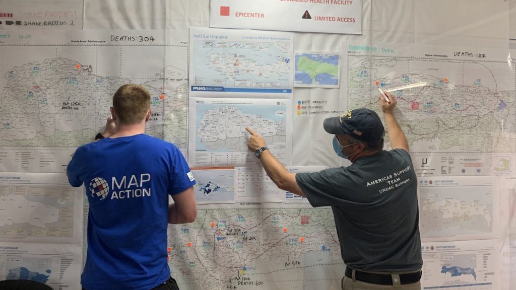
MapAction volunteer Chris Jarvis and a colleague from the Americas Support Team.
MapAction has been involved in the response to the earthquake that took place in Haiti on 14 August, helping our partners with data processing, analysis and mapping. This has helped those coordinating operational teams to understand what types of aid are needed in different locations and what other organisations are already doing to help. At the time of writing, this work is ongoing.
At the end of August, we scaled up our support to the UN Disaster Assessment & Coordination (UNDAC) and other responding organisations. Two MapAction volunteers traveled to Haiti to provide in-person assistance, supported remotely by our wider team. As well as using their annual leave to do this, both were required to self-isolate for 10 days after returning to the UK, in accordance with COVID rules. We are grateful to them both for their invaluable efforts.
This StoryMap looks at some of the maps that have so far been created during the response to the earthquake and how they have been used to help the situation on the ground.
Thousands of people are at risk of deadly floods in Suriname and Guyana so MapAction is responding to a request to provide rapid mapping support led by the Caribbean Disaster Emergency Management Agency (CDEMA).
Both countries have seen months of extreme rainfall, leading to flooding of up to 14 feet in some areas which is making some of the roads impassable and areas inaccessible. The resulting flooding is only likely to increase during the rest of the rainy season which continues until the end of July.
The area is low lying and much of the countries’ land is only a few meters above sea level, making them two of the world’s most vulnerable countries to flooding. They also have much of their industry, including mining, close to the coast, meaning that jobs, livelihoods and accessible drinking water is being put at risk. Inadequate drainage is also exacerbating the problem in the more densely populated urban areas.
We are supporting CDEMA with a three-person team of geospatial experts working remotely to provide maps and visualisations. We are also helping the United Nations’ Disaster Assessment and Coordination body (UNDAC) which is undertaking damage assessments and environmental management in both countries.
MapAction’s maps and other information products relating to this emergency will be available for Suriname and Guyana as the response develops.
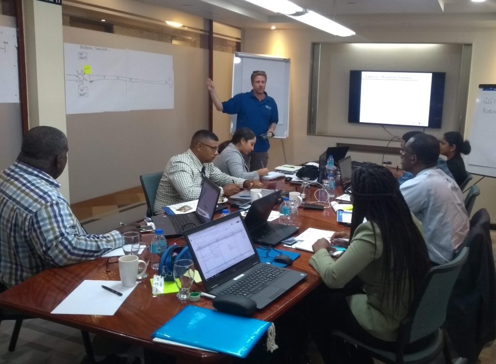
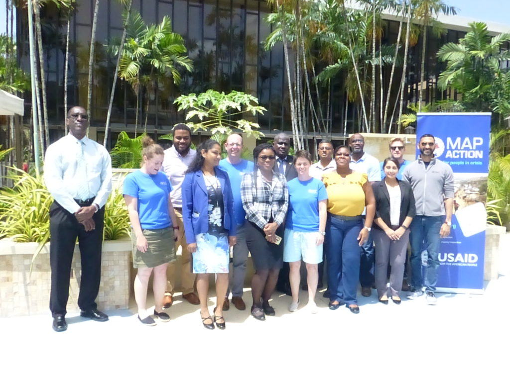
We are proud to be supporting the delivery of an online course in crisis mapping in the Caribbean this month. The training course will involve around 50 disaster management professionals from across the Caribbean and is in partnership with the Caribbean Disaster Emergency Management Agency (CDEMA), with input from the Humanitarian OpenStreetMap Team (HOT).
This is the second time the online course has been run, and we used our extensive deployment and training experience in the design and development of it.
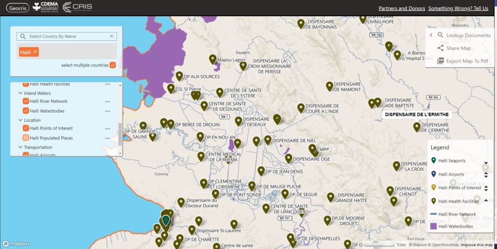
Screenshot of the GeoCRIS showing a map of part of Western Haiti with several map layers selected
As well as learning the principles of disaster mapping for response and resilience and OpenStreetMap data entry, the participants are practicing effective use of the GeoCRIS. This is the new regional repository for geospatial data needed for risk and hazard mapping, disaster preparedness and response operations. As MapAction was involved in setting up the GeoCRIS, we are well placed to design and deliver this training.
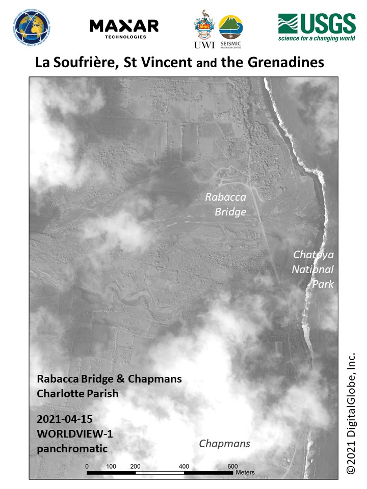
The month-long course also includes a disaster simulation exercise in which the students will have the opportunity to deploy their newly acquired skills in a realistic emergency scenario. Additionally, two members of MapAction’s Caribbean volunteer team who have both recently been involved in the response to the La Soufrière volcanic eruption will be running a live session to share their real-world experiences of emergency mapping in the region and answer questions.
We’re grateful to USAID’s Bureau for Humanitarian Assistance (BHA) for funding this activity as part of our ongoing programme to improve the ways in which geographical information systems (GIS), mapping and spatial analysis are used in humanitarian emergencies.
“Alert Check: Volcanic Eruption St Vincent and the Grenadines, please sign up your availability.” Those were the words which greeted me as I checked my MapAction email. Simple words, but so profound for me. They really hit hard, and hit home! I could not ignore that call for action. I signed up for remote deployment. It turned out to be my first official response deployment as a MapActioner!
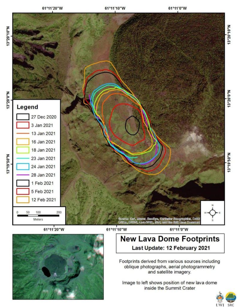
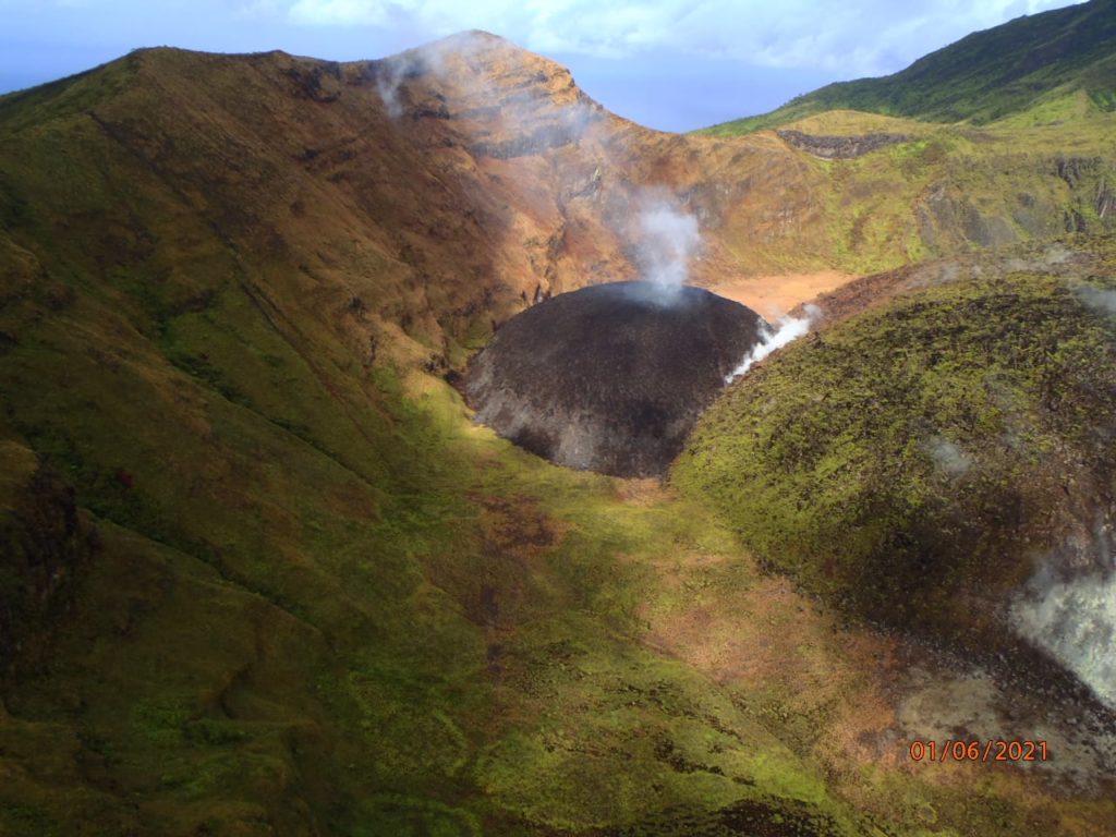
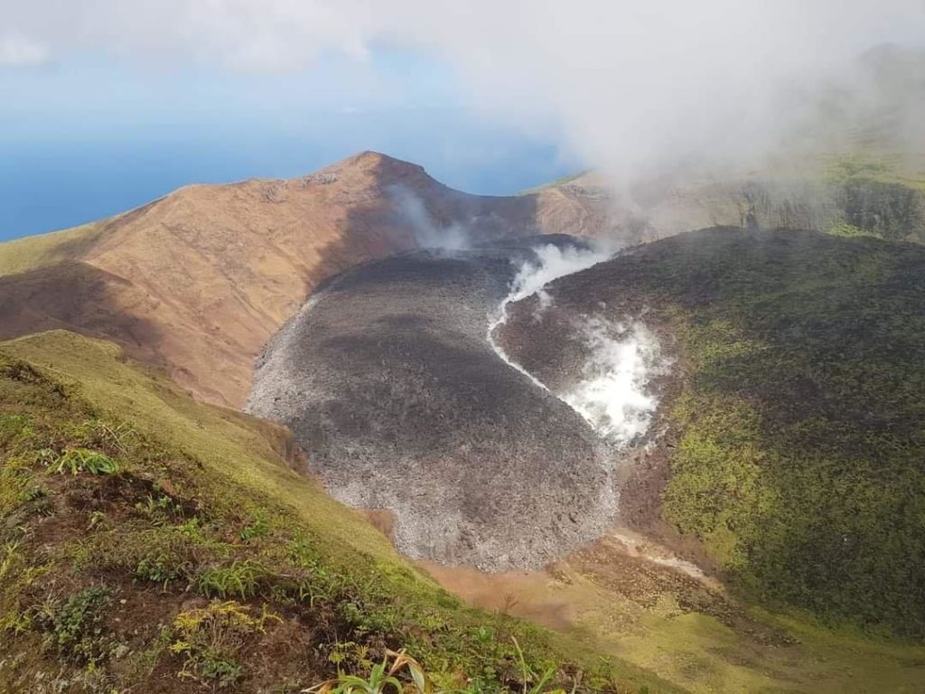
Like many people within the region, I have been observing the volcanic dome growth in St Vincent and the Grenadines since late 2020. As it grew, magma continued to fill the space around the old 1979 dome, as depicted in the images below.
Source: Scientific Resource CentrePhoto credit: NEMO, St. Vincent and the GrenadinesPhoto credit: NEMO, St. Vincent and the Grenadines
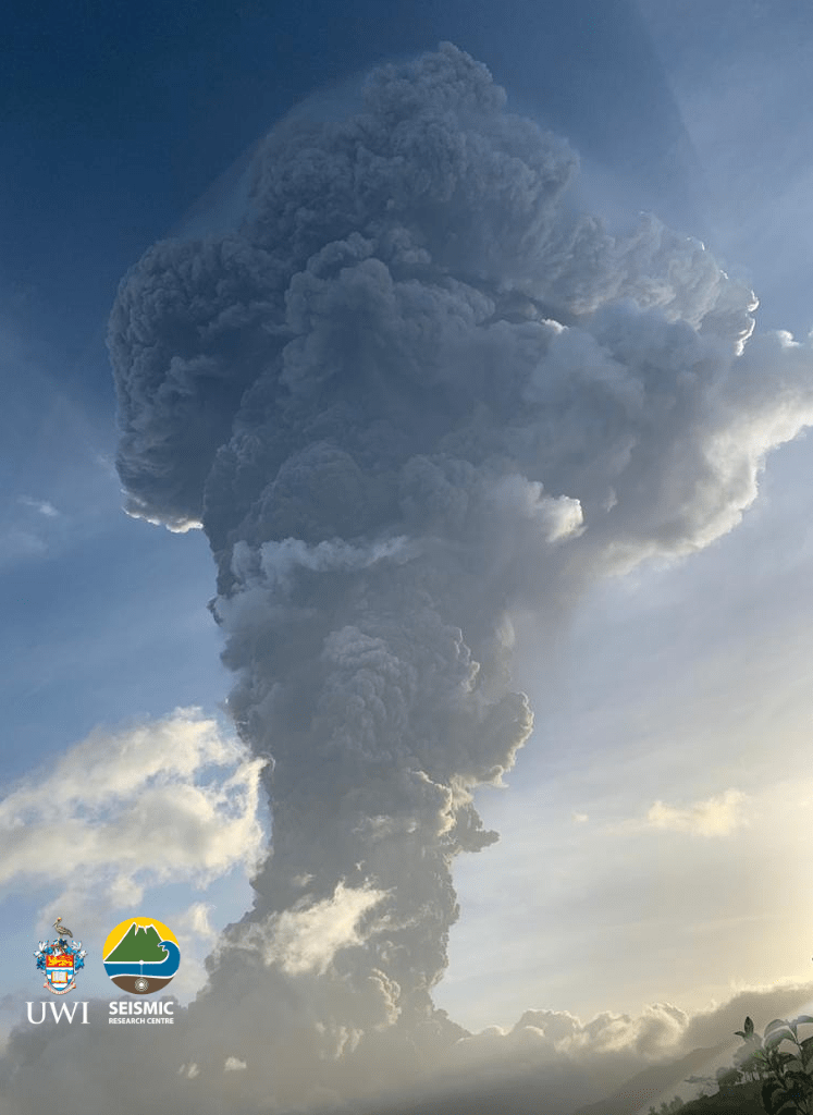
A period of elevated volcano-tectonic (VT) earthquakes, which began on 23rd March, 2021, indicated to scientists that the situation at La Soufrière had deteriorated. An evacuation order was issued on April 8, 2021 by Prime Minister Ralph Gonsalves.
The very next day, on April 9, 2021, La Soufrière Volcano erupted! The eruption was very visible to people around the world due to the prominence of posts on social media. It was easy to see live feeds and video posts as the action unfolded. Images of the massive mushroom plume created by the eruption brought back so many memories for me. It was beautifully dangerous!
Having experienced the eruption of our very own Soufrière Hills Volcano in Montserrat and having lived with an active volcano for the past two decades, I empathised with the residents of St Vincent and the Grenadines. Being displaced from one’s home to live in a shelter is no easy feat. Having to leave behind the beloved island you call home is even more challenging. I knew the road ahead for many people would be long and difficult. Hence my conviction to help in the best way I knew: – by providing geospatial support.
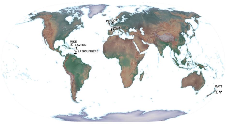
It was great news to discover that Mike was also selected as a member of this remote deployment team for the St. Vincent Response. Mike and I were recruited at the same time in 2019 to form part of the Caribbean Section of MapAction. The picture below is a throw-back to June 2019 in Trinidad. We had several days of intense conversion training sessions. In retrospect, those days really set the foundation for our ability to deliver during this response.
Our team was led by Matt who resides in New Zealand. He is very knowledgeable and has significant experience in deployments. We also received additional support from another volunteer, Pip, who is located in the UK. We supported the Caribbean Disaster Emergency Management Agency (CDEMA) for a period of three weeks. Subsequently, another two volunteers, Ant and Jorge, were deployed to support the environmental work of the United Nations Environment Programme’s (UNEP) response. We represented different time zones and locations from across the globe.
This unique team selection, worked out very well, as it offered 24 hour coverage for the St. Vincent response. Mike and I, being located in the Caribbean region, were uniquely placed to attend briefing meetings in our local time zone and follow up with any new developments; while Matt provided another level of support from New Zealand, as his day began when ours was coming to an end. No sleep lost – I guess! Our daily briefing meetings allowed us to report our findings during that day and to strategise the allocation and completion of tasks.
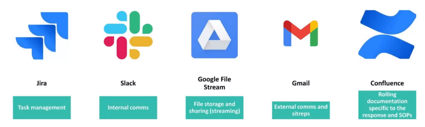
MapAction has mastered the ability to use different tools to share and work together in a remote working environment. In my opinion, the COVID-19 pandemic has only strengthened this area. The image below highlights some of the main tools we used to ensure smooth deployment coordination.
One of the major needs of any emergency response is geospatial data. The ‘data scramble‘ as the term is coined, involves the researching, collating and organising of all the spatial data available for a particular location, ensuring that it is fit for purpose. The data collected was prepared by transforming it into the correct projected coordinate system to allow for overlay and integration between different datasets. Datasets included administrative boundaries, such as parishes, census districts, shelter locations, elevation data, transportation networks, buildings, land use, hazard zones, and health centres, just to name a few. These were placed in appropriately themed folder locations so that it would be easy for deployed members to find them during the response.
Coordinating with CDEMA, MapAction provided mapping support to to aid in visualisation of the situation on the ground.
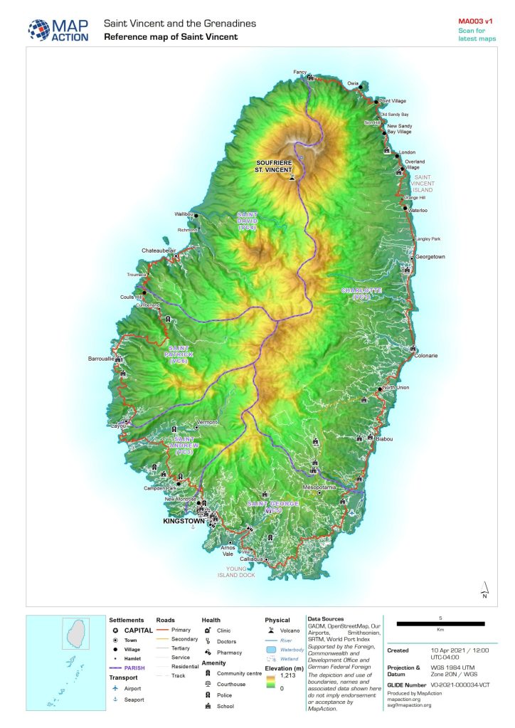
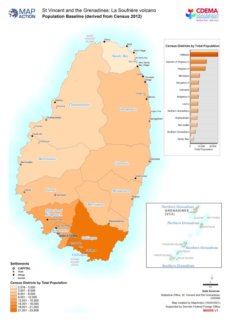
One of the first maps prepared is a reference map of the area. I consider this to be one of the most important maps to be prepared, as it gives context to the area of interest. Everything else is built upon this.
The basemap shown on the left below is detailed with settlement locations, roads, parishes, village names, rivers and elevation data. The baseline map sown on the right, highlights the population figures of St.Vincent derived from the most recent 2012 census survey. This allowed us to understand how the population is distributed throughout the affected areas.
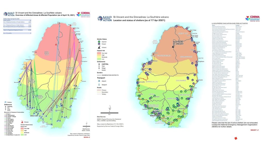
To provide further understanding, situational maps were prepared. Data being shared through situation reports from the Emergency Management Agency allowed us to create visual representations of what was happening on the ground. The map on the left, shows movement of displaced people from affected communities in the red, orange and yellow zones. The map on the right shows the location and status of the shelters.
Additionally, a 3D webmap was created showing the key volcanic events and hazards of the La Soufrière volcano. This dynamic map allows you to explore the data which was used to create the maps above and offers a better understanding of the risk posed by the volcanic eruption in St. Vincent.
3D webmap showing volcanic hazards
Working so closely with the data from St. Vincent during this period of time, allowed me to become very familiar with areas and village locations on the island. Seeing feeds on social media allowed me to identify quickly with where things were happening. Names such as as Chateaubelair, Troumaca, Byera, Owia and Fancy stood out to me!
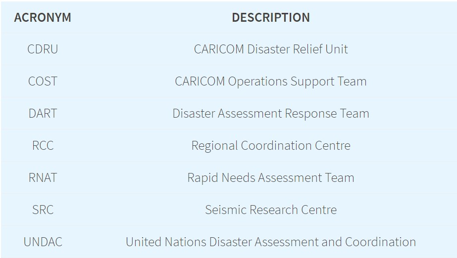
During my remote deployment, some acronyms were mentioned frequently during our briefing meetings. I eventually got the hang of them! These all form part of the response mechanism which helps the crisis on the ground to be addressed. Each of the teams highlighted below, played a very important function in being able to get supplies into St. Vincent, assessing the needs of the population and understanding the impact of the disaster on the island.
A number of other international organisations responded to the crisis in St Vincent and the Grenadines by activating their disaster response mechanisms and programmes. The links below provide additional insight into their response activities.
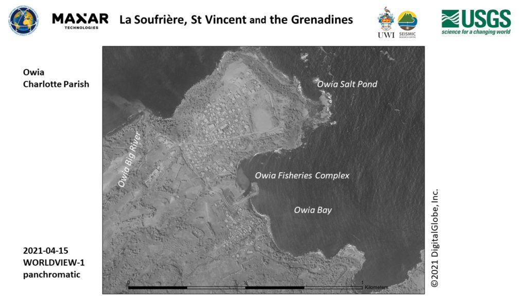
Satellite images like the ones below were captured as time progressed and further mapping and analysis was carried out. Derived information proved useful to responders on the ground.
MapAction is known to respond in-person during an emergency response deployment. Although the COVID-19 pandemic has limited this, my experience through this remote response deployment has shown that MapAction’s involvement is still significant in providing geospatial information to support the humanitarian needs of people in crisis. I do look forward to future deployments with MapAction!
This article was first published on Lavern’s own blog on 24 May 2021.
MapAction is providing mapping and information management support to the La Soufriere volcano emergency on the island of St Vincent, in response to requests from both CDEMA (Caribbean Disasters & Emergency Management Agency) and UN OCHA’s regional office.
Explosive eruptions from La Soufriere since April 9th have caused ash clouds to cover much of St Vincent, Bequia and southern St Lucia, as well large parts of Barbados. Pyroclastic flows have descended from the mountain top, after it was confirmed that the volcanic dome had collapsed.
Monitoring of the volcano is difficult as existing seismic stations were knocked out and it became dangerous to travel into the area. By the 7 of April, circa 16000 residents had been advised to evacuate following early signs of activity. The incident has already caused serious need for shelter, PPE and fresh water and is developing. Flooding is now reportedly compounding the situation.
MapAction is currently supporting the situation remotely, having already assembled a dedicated team of three volunteers and one staff member, located in Montserrat, the Turks & Caicos Islands (both in the Caribbean), New Zealand and the UK respectively. All members of the MapAction team will be working remotely due to the travel and other complications of the COVID-19 pandemic, and there are no current plans to send a geospatial team to the affected area, although two of the team are based in the Caribbean region.
The direct mission costs are being met by the German Federal Foreign Office. MapAction’s response capacity has been supported by UK Foreign, Commonwealth & Development Office (FCDO) and the Netherlands Ministry of Foreign Affairs, and we have been working extensively in the Caribbean region on disaster preparedness work thanks to USAID Bureau of Humanitarian Affairs.
The mapping techniques used in the 3D web mab above are based on recent work by MapAction and the University of Edinburgh, which pioneered 3D interactive webmapping for planning and response to volcanic hazards.
Many of MapAction’s maps and other information products relating to this emergency will be available here as the emergency develops.
Launched today, the Caribbean Risk Information System (CRIS) is a “one stop shop” for gathering and sharing information and data on disaster risk management and climate change adaptation across the Caribbean region.
The CRIS platform has been created by the Caribbean Disaster Emergency Management Agency (CDEMA) in collaboration with the World Bank and other partners including MapAction, with financial support from the European Union (EU).
CRIS aims to support informed decision making by providing access to information on all types of hazards, including climate-induced hazards, as well as guidance on how to reduce risk, build disaster-resilient states and promote sustainable development. It consists of a Virtual Library, databases and the GeoCRIS – a geospatial component which provides access to geospatial data needed for risk and hazard mapping, disaster preparedness and response operations. Data from the Caribbean Handbook on Risk Information Management (CHaRIM) GeoNode has been integrated into the GeoCRIS to facilitate evidence-based decision making and development planning processes.
Screenshot of the GeoCRIS showing a map of part of Western Haiti with several map layers selected
MapAction provided advice on strategic, technical and personnel issues related to creating the GeoCRIS, based on its years of experience of developing similar systems. We particularly assisted in defining needs for data and tools to support the Rapid Needs Assistance Team (RNAT) and other rapid-response mechanisms within CDEMA as we have partnered alongside CDEMA following several devastating hurricanes in the past five years. We will also be helping CDEMA to train disaster management teams across the Caribbean region in using GeoCRIS once travel restrictions are lifted.
We’re grateful to the USAID’s Bureau for Humanitarian Assistance for funding our participation in this project.
MapAction teams are in action again, this time providing support to the humanitarian responses to Hurricane Eta in Central America and Tropical Typhoon Goni in South East Asia.
Hurricane Eta – A coordinated team of MapAction GIS volunteers is working remotely in support of UN OCHA’s Regional Office for Latin America and Caribbean (ROLAC) as they coordinate the humanitarian response across Central America in the wake of Hurricane Eta. Over 1.8 million people have been affected across Nicaragua, Honduras, Guatemala, El Salvador and Belize.
The team are already delivering mapping support for the immediate aftermath of the hurricane and are preparing to deliver 3W and flood mapping. It is anticipated that further support may also be required with this fast developing situation and we are standing by for requests. You can see the maps and other products produced so far here. You can see further MapAction-aided products on the Reliefweb site.
Hurricane ETA is a Category 4 hurricane that made landfall in Nicaragua on Tuesday Nov 3rd and moved north through Honduras, Guatemala, El Salvador and then Belize. Eta is now a Tropical Storm and is due to hit Cuba in the next 24 hours. The Central American region has suffered widespread flooding, storm surges and landslides. Honduras, Nicaragua and Panama are under red alerts. Guatemala has also been severely affected. For further situation information see the most recent OCHA needs snapshot and Relief Web update.
MapAction is grateful to the German Federal Foreign Office for supporting our response, as well as to the Netherlands Ministry of Foreign Affairs and the UK FCDO for their continued support of MapAction’s response capacity.
Tropical Cyclone Goni – This typhoon is affecting people across the Philippines and Vietnam. A member of the team is supporting MapAction partner the AHA Centre (ASEAN Coordinating Centre for Humanitarian Assistance on Disaster Management) as it coordinates the response. You can see the maps and other products here. You can see further products on the Reliefweb site.
As UN assessment teams make their way to some of the hardest hit areas, a clearer picture of Typhoon Goni’s impact (known locally as Rolly), which made landfall in the Philippines on Sunday, is emerging. The UN OCHA office reported that as of 6 November, around 1.2 million people (more than 312,500 families) across seven regions have been directly impacted by the disaster. “As more than 21,000 homes were destroyed, many families will remain in long-term displacement,” it reported.
MapAction has been helping its partners the World Food Program (WFP) and Caribbean Disaster Emergency Management Agency (CDEMA) to distribute mobile app questionnaires about availability of and access to food during the COVID-19 pandemic.
Over the past several years, we have been working with CDEMA and other organisations to build a network of GIS professionals in the Caribbean region (and elsewhere) with a shared interest in disaster preparedness and information management. We were able to use this network to help disseminate the questionnaire as widely as possible across the region in order to gather information about potential food shortages once incidences of the virus escalate.
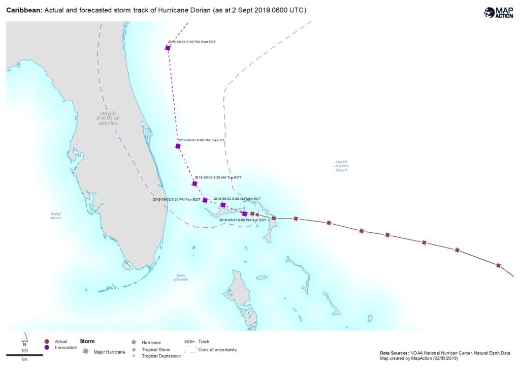
A MapAction team is en route to the Bahamas to support the Caribbean Disaster Emergency Management Agency (CDEMA) and the UN Office for the Coordination of Humanitarian Affairs (UNOCHA) as they coordinate the response to Hurricane Dorian. Our UK support base has already been working over the weekend on vital maps and data.
With windspeeds over 160mph, the category 5 Hurricane is the strongest to hit the Bahamas since records began. It is moving slowly westards across the Abaco Islands and Grand Bahama.
We are grateful to the UK’s Department for International Development (DFID) and the Netherlands Ministry of Foreign Affairs for enabling us to help provide the geospatial input that’s needed to get aid to where it’s most needed as quickly as possible.
By Lavern Rogers-Ryan, MapAction Caribbean Section volunteer
When the call came for Caribbean volunteers to apply to MapAction, I was keen to sign up. Having followed the work of this organisation and the amazing group of people who work as volunteers, I saw this as an awesome opportunity for me to contribute to the work of saving lives.
Living in Montserrat, with an active volcano and being privy to how devastating disasters can be, I was grateful for the prospect of being able to use my skills in geospatial technologies to contribute to humanitarian efforts during a disaster. My mind quickly raced back to the impact Hurricanes Irma and Maria had on my neighboring Caribbean Islands, in 2017. I wanted to be in a better position to offer assistance if a situation like that – God-forbid – presented itself again.
I therefore submitted an application to the organisation and not very long after, I was greeted with an email inviting me to an ‘assessment day’. Needless to say, I was very happy to advance to the next stage.
The assessment day turned out to be very interesting. Surprisingly, during the introductory session, I was reintroduced to the Head of the MapAction Caribbean Section, who reminded me that we met while he visited Montserrat in another capacity several years before. Moreover, the gentleman who is the Preparedness Lead for MapAction worked in Montserrat briefly on a project back in the early 2000s. I found it to be very fascinating how unsuspectingly our paths crossed again! In addition, hearing the testimony of a fellow MapAction volunteer sort of sealed the deal for me. He explained what being a volunteer all entailed and how my skills can contribute to saving lives.
Overall, this interview process was detailed enough to ensure that I was a good fit for MapAction. Amongst other skills, the panel assessed team spirit, leadership potential and the knowledge and application of geographic information systems (GIS) tools and software.
Receiving another email shortly after assessment day, entitled, “MapAction Caribbean Section – Interview Outcome”, I nervously but anxiously opened it. The words that bounced from my computer screen, read: “Congratulations, you have been selected to join our Caribbean Team!”
This was awesome news and I am absolutely thrilled to be apart of the MapAction family and be able to contribute to society in this capacity.
I look forward to sharing more about the work of MapAction and my experiences in future blogs.
Lavern Rogers-Ryan is a geospatial consultant specialising in disaster risk management and recovery. She is currently head of the GIS Centre within the Government of Montserrat.
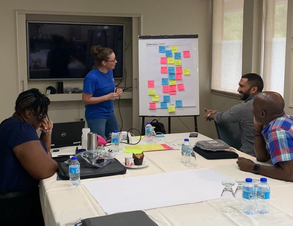
Two MapAction training courses are in progress in Trinidad & Tobago this week.
Three MapAction team members are privileged to be working with members of civil protection response teams from Trinidad & Tobago, Guyana and Surinam. We are collaborating to share geospatial skills and experiences to support readiness for response to communities.
In the region, hurricanes and storms are a key concern, but several countries also respond to a multitude of different concerns affecting their citizens including earthquakes and other seismic risks.
We are very grateful for the support of The Office of Disaster Preparedness and Management of Trinidad & Tobago for their support. This is part of an ongoing joint programme we are carrying out with the Caribbean Disaster Emergency Management Agency (CDEMA). We have already run humanitarian mapping courses with CDEMA in Antigua & Barbuda, Barbados and Jamaica. This important work is funded by US Foreign Disaster Assistance (OFDA).
Training MapAction’s latest recruits
Also in Trinidad & Tobago this week, the newest members of MapAction’s Caribbean section are being put through their paces on our Conversion Course which, through a combination of theory and practical exercises, prepares our GIS expert volunteers for deployments to humanitarian emergencies.
The week-long course covers numerous topics including sources and collection of humanitarian data, mapping in emergency conditions, priority needs and the timeline of a response.
Earlier this year we embarked on a round of volunteer recruitment to find mapping and geographical information system (GIS) experts living and working in the Caribbean. The aim was to expand our small team in the region to ensure we are always well placed to help prepare for and respond to disasters and emergencies across the Caribbean, working with our close partner the Caribbean Disaster Emergency Management Agency (CDEMA). This includes pre-positioning personnel when necessary to provide mapping and data support in the event of severe tropical storms.
We are delighted to now welcome three exceptionally high-calibre volunteers who bring a tremendous amount of additional knowledge, expertise and energy to an already very strong Caribbean team.
Deanesh Ramsewak
Deanesh lives in Trinidad and is a lecturer and researcher at the Centre for Maritime and Ocean Studies (CMOS) of the University of Trinidad and Tobago. He teaches GIS and remote sensing and has recently worked on a multi-agency research project funded by NASA, using drones for studying coastal ecosystems. His work has been published in international and regional journals and he is a fellow of the Royal Geographical Society.
My interest in MapAction began after the devastating 2010 Haiti earthquake. The response by MapAction volunteers to it, as well as to other Caribbean disasters since then, inspired me to join the humanitarian effort.
Deanesh Ramsewak
Deanesh also volunteers as a mentor for the Caribbean Youth Science Forum (CYSF), the longest standing non-formal STEM education programme in the region, as well as for a local non-profit organisation called Restore a Sense of I Can (RSC) which seeks to effect change through technology and education. In his free time he enjoys travelling, meeting new people, swimming and yoga.
Lavern Ryan
Lavern is from the beautiful Caribbean island of Montserrat where she lives and works as a GIS Manager. She loves travelling, meeting new people and learning about new cultures. She especially loves star gazing!
Following the events of the 2017 hurricane season, I wanted to use my skills more to help mitigate against the impacts of disasters. When the call came for Caribbean GIS professionals to join MapAction, I was further inspired. I am passionate about GIS and I want to use my knowledge and skills to help people when they are most in need and to help to save lives. MapAction provides the platform for me to do just that!
Lavern Ryan
Mike Clerveaux
Mike is currently the Hazard Mitigation and GIS Specialist within the Department of Disaster Management and Emergencies (DDME), Turks and Caicos Islands. He is an Urban and Regional Planner by profession and holds a Masters degree in Built Environment with a specialisation in Geomatics. He joined the Disaster Management Team in 2016 and that same year was part of the CDEMA Regional Response Mechanism that was deployed to the Bahamas following Hurricane Matthew, which was when he first encountered MapAction.
Prior to joining DDME, Mike was a volunteer in Damage and Needs Assessment (DANA) as well as lead facilitator for them. Outside of Disaster Management, Mike is happily married with three girls. He enjoys carpentry and coaching basketball.
“Ever since Hurricane Matthew, I was eager to be a part of MapAction. I look forward to serving in this new capacity and being a part of the MapAction family.”
In recent years we have begun working closely with the Caribbean Disaster Emergency Management Agency (CDEMA) to help prepare for and respond to disasters and emergencies in the Caribbean region. We collaborated around the responses to Hurricane Matthew in 2016, Hurricanes Irma and Maria in 2017 and last week’s Tropical Storms. We have also begun to provide mapping training to Caribbean disaster responders.
Through these joint activities, we have built up a strong working relationship with CDEMA and last week this partnership was formalised through the signing of a Memorandum of Understanding (MoU) at a ceremony in Barbados. This states that we will continue to work alongside CDEMA teams as well as supporting National Disaster Management Agencies within the Caribbean region as needed. We are helping them to improve their use of data gathering, mapping and analysis so that they can provide disaster response support quickly and in the right places. In the event of an emergency in the Caribbean region, we help CDEMA to obtain the most complete, accurate and detailed data available in the fastest possible time. As well as providing remote support, we send MapAction team members as needed to the affected location and, in certain situations, we preposition people to ensure an immediate response.
MapAction’s Chief Executive Liz Hughes traveled out to Barbados for the MoU signing ceremony. “Collaboration and partnership are fundamental to MapAction’s approach,” she commented. “We are delighted to have the opportunity to deepen and formalise our working relationship with CDEMA and we are keen to support them and their partners in whatever way we can.”
MapAction’s work to support CDEMA and national agencies in the Caribbean through training and preparedness activities is funded by the European Union Civil Protection and Humanitarian Aid (EU ECHO).
Storms Isaac, Florence, Joyce and Helene are currently passing across the Caribbean region and Southern USA and we are monitoring and mapping their progress together with forecasts of likely wind speeds, storm surges, flood risks and other hazards. Isaac is due to pass over Dominica, Guadeloupe, Antigua and Barbuda today, bringing very high winds and heavy rain. Currently it looks as if Dominica is at greatest risk of flooding.
MapAction member Jonny Douch is in Barbados where he is providing support to the Caribbean Disaster Emergency Management Agency (CDEMA) which is headquartered there. Jonny has been in the region for the past three weeks, delivering mapping training to members of the teams that make up CDEMA’s Regional Response Mechanism and supporting the UN Disaster Assessment Coordination (UNDAC) with preparedness activities in St Maarten. He has stayed on in Barbados to help with the storm response. We also have a small team of trained Disaster GIS Volunteers who live in the region and other team members are on standby to help as needed.
MapAction has significant recent experience and strong working relationships in the Caribbean, having provided GIS teams and other assistance in response to several hurricanes and the Haiti earthquake, as well as training and preparedness activities. Ronald Jackson, Executive Director of CDEMA, said this week, “We had the opportunity to work closely with members of the MapAction team during the response to Hurricanes Matthew in 2016 and again during Irma and Maria in September 2017, and from this collaboration, we understood the benefits that their mapping and information management expertise could bring to our own operations.”
We hope that damage caused by this week’s storms is not as severe as that caused by Hurricanes Irma and Maria a year ago, but we are keen to support responders in the region in any way we can.
In addition to the Caribbean storms, we are monitoring Super Typhoon Mangkhut which has the potential to affect 43 million people in the Philippines.


 Reportan intensas lluvias y fuertes ráfagas de viento en Playa del Carmen, Tulum y Cancún, Quintana Roo, por el ingreso del huracán
 , supported by
  partners. PM


 (CDEMA) to help prepare for and respond to disasters and emergencies in the Caribbean region. We collaborated around the responses to
 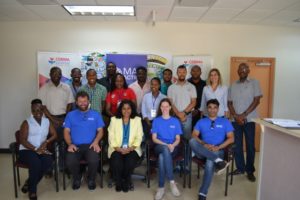 MapAction’s Chief Executive Liz Hughes traveled out to Barbados for the MoU signing ceremony. “Collaboration and partnership are fundamental to MapAction’s approach,” she commented. “We are delighted to have the opportunity to deepen and formalise our working relationship with CDEMA and we are keen to support them and their partners in whatever way we can.”