This has been our busiest ever year. We asked people from across our team what their 2020 was like at MapAction. This is what they told us:
Tag: Corona
Helping WHO with mapping in Libya and Chad
MapAction volunteers have been supporting the World Health Organization (WHO) in Libya and Chad to process and map data about health and sanitation services, in order to support the response to COVID-19.
The volunteers have been working remotely, alongside each country’s health cluster (networks of WHO partners that work together to relieve suffering and save lives in humanitarian emergencies). They have been helping to identify and map what healthcare, water and sanitation services and aid are being provided, by whom, when and where. This is known as 4W mapping and is important to help identify gaps and avoid duplication.
We are now looking at providing similar assistance to WHO in other parts of North and Central Africa.
MapAction provides GIS support for MSF’s COVID response
MapAction’s partner Médecins Sans Frontières (MSF) provides rapid-response medical teams to assist in conflict zones, natural disasters and epidemics. On any given day, its staff treats tens of thousands of patients for a variety of illnesses in its medical programmes around the world.
MSF is very concerned how the COVID-19 pandemic will affect people in countries with already fragile health systems. In many areas where its teams work, there are few medical organisations in a position to respond to an overload of patients.
In order to provide the best medical aid as fast as possible, MSF is working with its technical partner CartONG to create a single repository for all the information its operations personnel need to rapidly respond to the COVID crisis, including information about travel restrictions, flights, cargo transport, availability of supplies, etc. A MapAction team member has been seconded to this technical task force in the role of GIS coordinator. As well as bringing technical expertise in data and content strategy, he’s helping to define and prioritise the information needs of MSF teams and create content for the new platform.
MapAction’s Caribbean network helps prepare for COVID-19
MapAction has been helping its partners the World Food Program (WFP) and Caribbean Disaster Emergency Management Agency (CDEMA) to distribute mobile app questionnaires about availability of and access to food during the COVID-19 pandemic.
Over the past several years, we have been working with CDEMA and other organisations to build a network of GIS professionals in the Caribbean region (and elsewhere) with a shared interest in disaster preparedness and information management. We were able to use this network to help disseminate the questionnaire as widely as possible across the region in order to gather information about potential food shortages once incidences of the virus escalate.
Helping UN Asia Pacific COVID-19 response
A MapAction team member currently based in New Zealand is providing GIS, mapping and information management support to the UN Office for Coordination of Humanitarian Affairs (OCHA) in Asia and the Pacific (ROAP).
Over the next two months, he will be helping ROAP to support countries that have limited public health infrastructure and resources to cope with the rapid onset of COVID-19. He will be assisted in this work by MapAction’s team of volunteers.
ROAP covers 41 countries in Asia and the Pacific and currently supports these countries in their efforts to ramp up preparedness and response through the UN Resident Coordinators and their offices, as well as local governments.
COVID-19 government measures dashboard
We’ve helped ACAPS to put together a dashboard showing government measures being taken around the world. Data can be filtered by region, country, type of measure and timeframe.
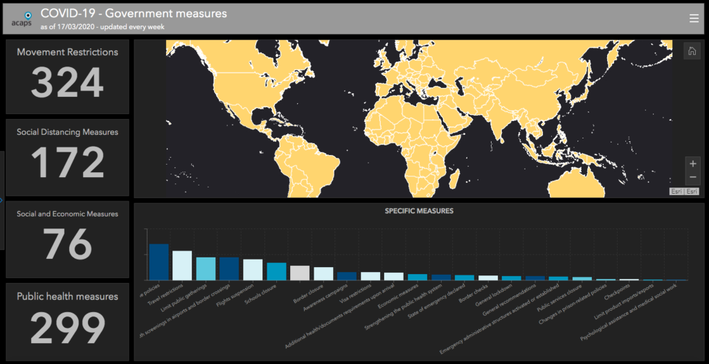
We will be updating this twice a week. In the meantime ACAPS, MapAction and other organisations are looking at further topics to develop analysis for.