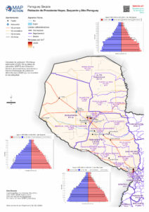
Parts of Paraguay are experiencing a devastating drought. A La Niña weather pattern is being compounded by three consecutive years of poor rainfall. The Western region, or Chaco zone, where almost half the population is indigenous (approximately 44%), is particularly badly affected by the drought which is predicted to worsen and last until at least the beginning of 2023.
The drought is impacting access to water, health, food security and the livelihoods of large numbers of families (due to huge losses in farming), and is exacerbating the often fragile conditions of indigenous populations and farming communities. This situation makes the country very vulnerable to climate change impacts.
The Governor of the Boquerón department in the North West has made a request for urgent assistance, resulting in a combined UN Disaster Assessment and Coordination (UNDAC) and MapAction team mission. Together, the team will undertake a rapid needs assessment of six regions. This will provide information on the impact of the drought and the humanitarian situation in the most affected areas and inform the Government’s decision-making process and how best to respond.
MapAction has deployed one of its highly experienced specialists, Luis Velasquez, who will be using his skills to supply situational data analysis, visualisation and geospatial expertise. A remote team will also be helping with data gathering and map generation.
A serious drought is affecting parts of East Africa. Three consecutive failed rainy seasons has meant crops are failing, livestock is being badly affected and cereal prices are rocketing.
A drought warning has already been issued for many parts of northern and eastern Kenya – a mainly rural area with already high rates of poverty. Forecasts indicate that the food security situation is only likely to get worse, meaning that many more households will soon be in need of urgent humanitarian assistance.
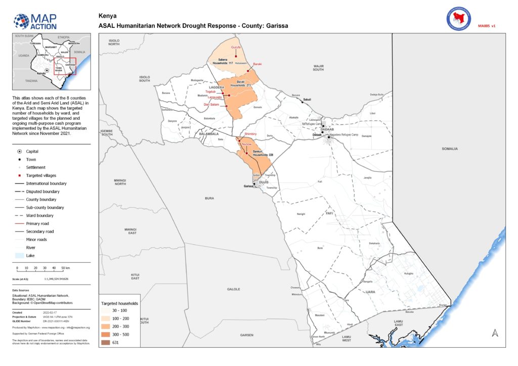
MapAction’s support was requested by the Arid and Semi Arid Lands (ASAL) Humanitarian Network – a group of more than 30 local Civil Society Organisations (CSOs), community groups. Together with its partners (ACTED, Concern Worldwide and Oxfam), they are focused on the dry ASAL region of Kenya which has been particularly badly affected. More than 2.9 million people are at risk of going hungry and losing their livelihoods here, and thousands of young children are in urgent need of treatment for acute malnutrition.
A large part of the response has involved multi-purpose cash transfers to communities which are aimed to boost the local economy, and protect lives and livelihoods. So far it has reached over 5,000 affected households.
Since November 2021, MapAction has been supplying information management to the ASAL Humanitarian Network to support this response. We have provided tools to help manage their data on the response which then meant this information could be mapped. Once the information was on a map we could verify the data and this subsequently allowed the response to be presented at detailed village and ward level, rather than at regional level. This level of detail in our visualisations showed which partner was responding where, in which village location and what the response entailed.
MapAction also analysed and mapped the baseline drought survey commissioned by ASAL Humanitarian Network in November 2021. This survey assessment showed indicators such as the length of drought, and the impact of drought on crops, livestock and conflict. Mapping these indicators allowed the survey information to be visualised and compared across sub-counties highlighting key issues that the drought has impacted.
By mapping the drought response at various geographic levels, we were able to communicate the impact of the programme in a powerful way. This allowed ASAL Humanitarian Network to share these maps with partners, donors and within the network itself to explain and also help drive decision making.
As well as increasing prospects of drought, many of these very dry arid and semi-arid areas have been degraded from deforestation and overgrazing, which further reduces the productivity of these lands. This threatens food security, livelihoods and biodiversity. Early action from MapAction and other agencies aims to prevent loss of life and sustain livelihoods in these areas.
MapAction is grateful to the German Federal Foreign Office for funding this work.
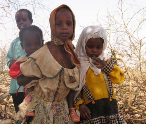
DAKAR, 9 Feb – A severe food crisis is forecast to strike the Sahel region of West Africa later in 2012, potentially affecting 7 to 10 million people in eight countries (Senegal, Mauritania, Mali, Burkina Faso, Niger, Nigeria, Chad and Cameroon). Low rainfall, poor harvests and high food prices are making communities vulnerable to extreme malnutrition. The number of children dying from nutrition-related causes is already estimated at more than 490,000 per year.
MapAction has deployed a team of two volunteers to undertake a mapping preparedness project from the UNICEF regional office in Dakar, Senegal. The team will work with UNICEF information management staff to do preparatory map setup and initial vulnerability maps, with a focus on food security and nutrition.
This is MapAction’s third deployment to the Sahel region. In 2005, our volunteers helped map priority needs in a food crisis in Niger and in 2009 we responded to floods in Burkina Faso.
 DAKAR, 9 Feb – A severe food crisis is forecast to strike the Sahel region of West Africa later in 2012, potentially affecting 7 to 10 million people in eight countries (Senegal, Mauritania, Mali, Burkina Faso, Niger, Nigeria, Chad and Cameroon). Low rainfall, poor harvests and high food prices are making communities vulnerable to extreme malnutrition. The number of children dying from nutrition-related causes is already estimated at more than 490,000 per year.