Thank you for opening MapAction’s Humanitarian Response Appeal. We need your urgent help as we seek to fund our continuing responses to humanitarian crises in 2023 and beyond.
If you fund MapAction you won’t be buying blankets, water, shelter or food. You will be making sure that as those items arrive they get to where they are needed most, as quickly as is possible.
The maps we make help to inform the activities of many different streams of aid, making sure that the most up-to-date information is being used to identify the greatest need. Understandably situation maps and data are not the first thing you might think of when hearing about a response, but just imagine trying to plan search and rescue, emergency health care or efficient aid delivery without maps showing you what is happening, where, and just as important, where the needs are.
Roberto Colombo Llimona, Head of the UN OCHA Assessment & Analysis Cell for the first phase of the Turkiye response, had to support humanitarian decision-makers immediately after the Turkiye earthquake. He said: “Investing in MapAction is a great way to support humanitarian operations…supporting Mapaction is supporting response directly”.
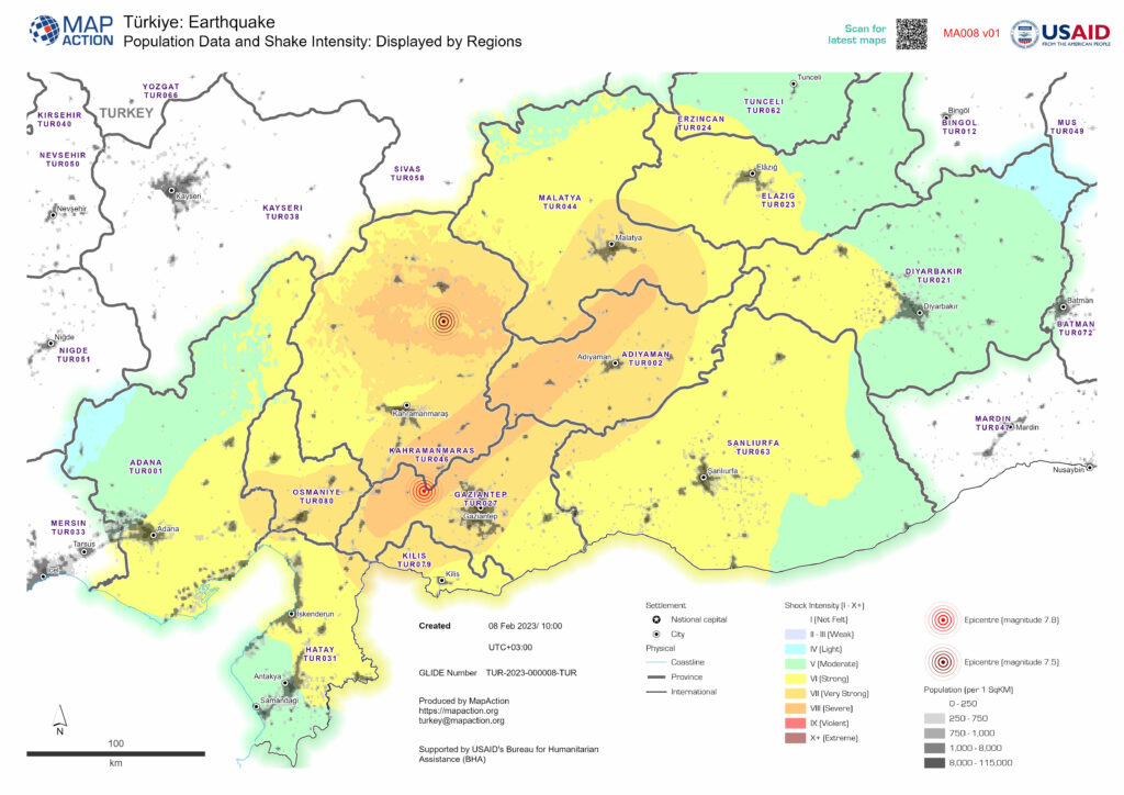
An early map overlaying population density and shake zones in Turkiye, to give early indication of likely priority need.
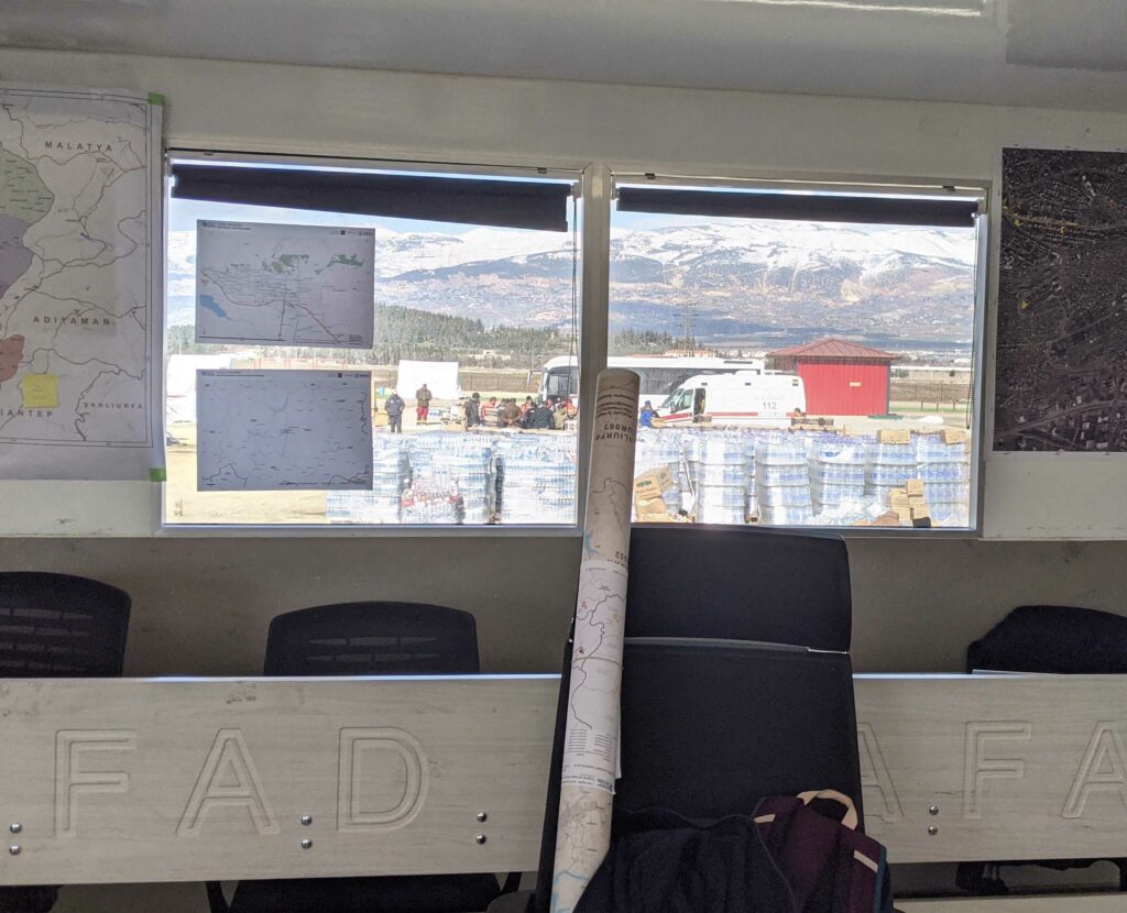
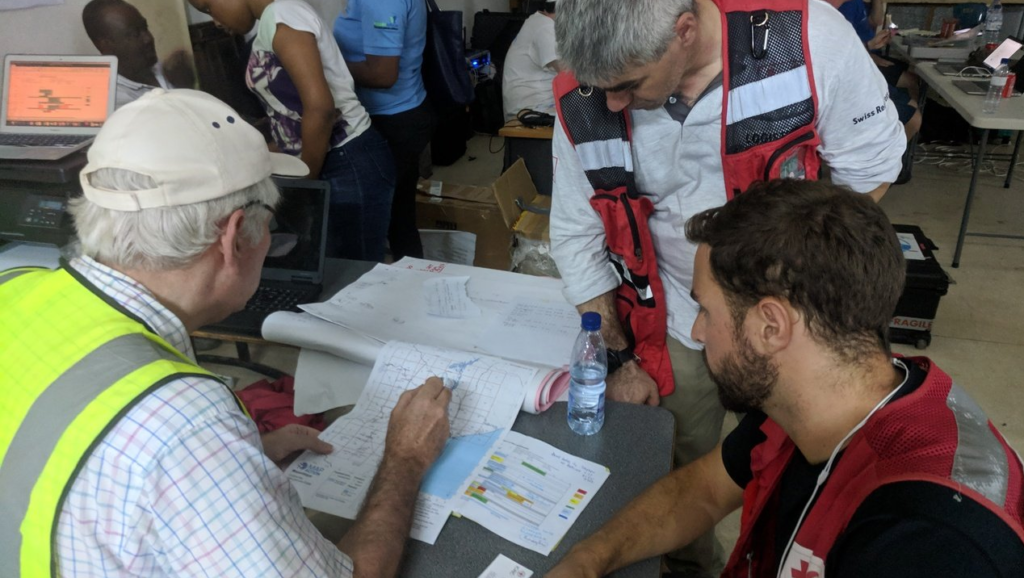
MapAction’s field teams are the most visible part of our activity, but more often MapAction members are supporting situations remotely, making maps, preparing data, each as qualified and experienced as the team members in the field.
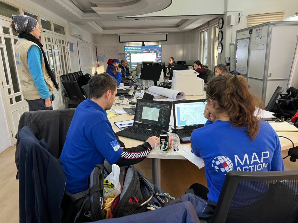
Above : MapAction Field Team members working in the UN Onsite Operations Coordination Centre in Gaziantep, Turkiye.
Why Support MapAction?
MapAction has a unique capability to help in humanitarian crises. Turkiye/Syrian Arab Republic is MapAction’s 12th earthquake and our 137th response: we bring a wealth of knowledge, know-how and operational insight. Immediately after news of this latest devastating earthquake broke, UNDAC, one of many long-standing partners of MapAction, requested support.
MapAction responded immediately, as we always want to do. However there is a significant cost for MapAction to maintain and provide well-trained, well-supported teams, very rapidly. As an organisation we aren’t large enough to receive funds from the big TV and newspaper appeals, so we must raise the money however we can. This is increasingly a combination of trusts and foundations, corporate support, (often from mapping, geospatial and data-related businesses) and private individuals. We are grateful to them all.
If MapAction’s support can’t be provided when its asked for, responses to disasters may be less effective and more costly. Supporting MapAction can save lives, and make scarce resources go further.
Please help us to continue this vital work. Whilst highly-valued and regularly requested, MapAction’s response missions have no direct funding right now. We no longer need immediate funding for the Turkiye/Syria earthquake response, but we do need funding for the next mission and those after that, to ensure we can get on the plane without hesitation . Any donation, big or small, matters right now.
Please partner with MapAction to ensure that all aid gets to where it is needed most, for the many people affected by humanitarian emergencies. Thank You.
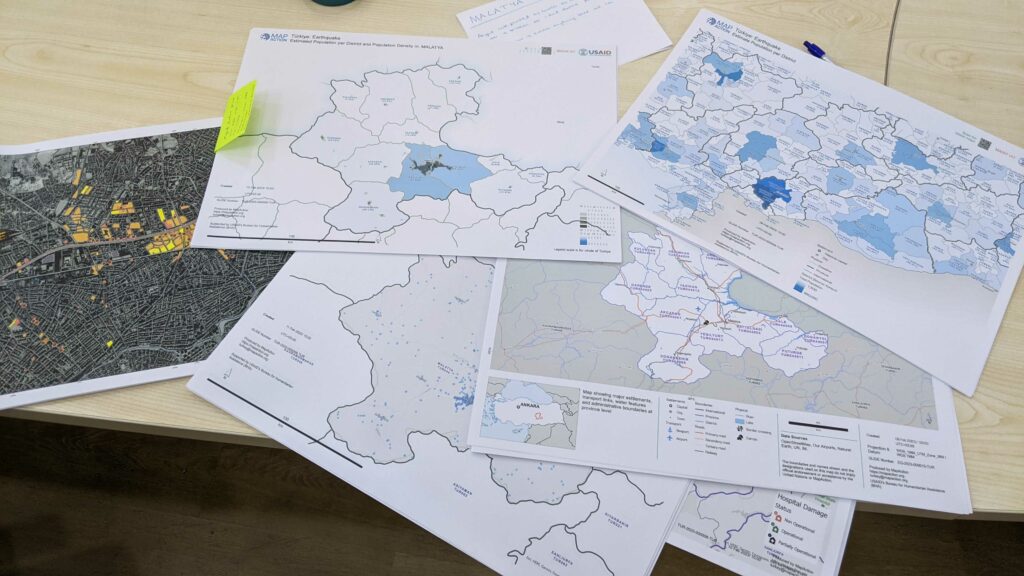
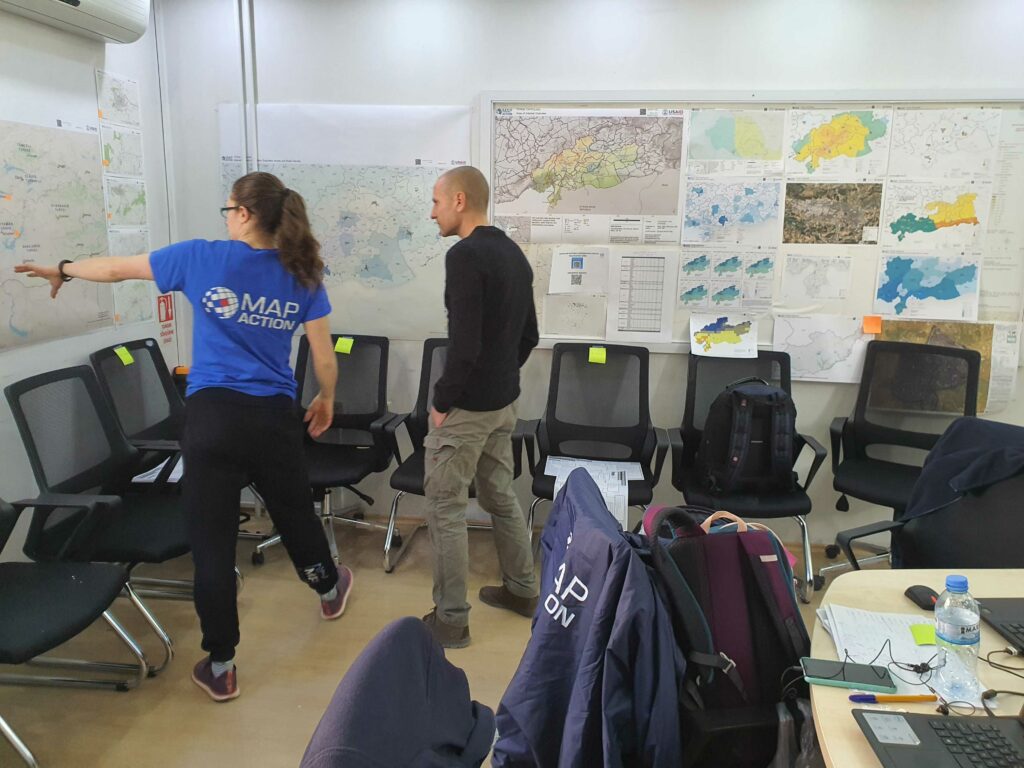
An early map overlaying population density and shake zones in TurkiyePart of a large batch of maps being printed for field teams. in the morning.The OSOCC Map Wall is a fast way to orientate a new responder to the operrating pictureMapAction Maps being used at a local field coordination centre in Turkiye
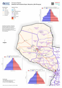
Parts of Paraguay are experiencing a devastating drought. A La Niña weather pattern is being compounded by three consecutive years of poor rainfall. The Western region, or Chaco zone, where almost half the population is indigenous (approximately 44%), is particularly badly affected by the drought which is predicted to worsen and last until at least the beginning of 2023.
The drought is impacting access to water, health, food security and the livelihoods of large numbers of families (due to huge losses in farming), and is exacerbating the often fragile conditions of indigenous populations and farming communities. This situation makes the country very vulnerable to climate change impacts.
The Governor of the Boquerón department in the North West has made a request for urgent assistance, resulting in a combined UN Disaster Assessment and Coordination (UNDAC) and MapAction team mission. Together, the team will undertake a rapid needs assessment of six regions. This will provide information on the impact of the drought and the humanitarian situation in the most affected areas and inform the Government’s decision-making process and how best to respond.
MapAction has deployed one of its highly experienced specialists, Luis Velasquez, who will be using his skills to supply situational data analysis, visualisation and geospatial expertise. A remote team will also be helping with data gathering and map generation.
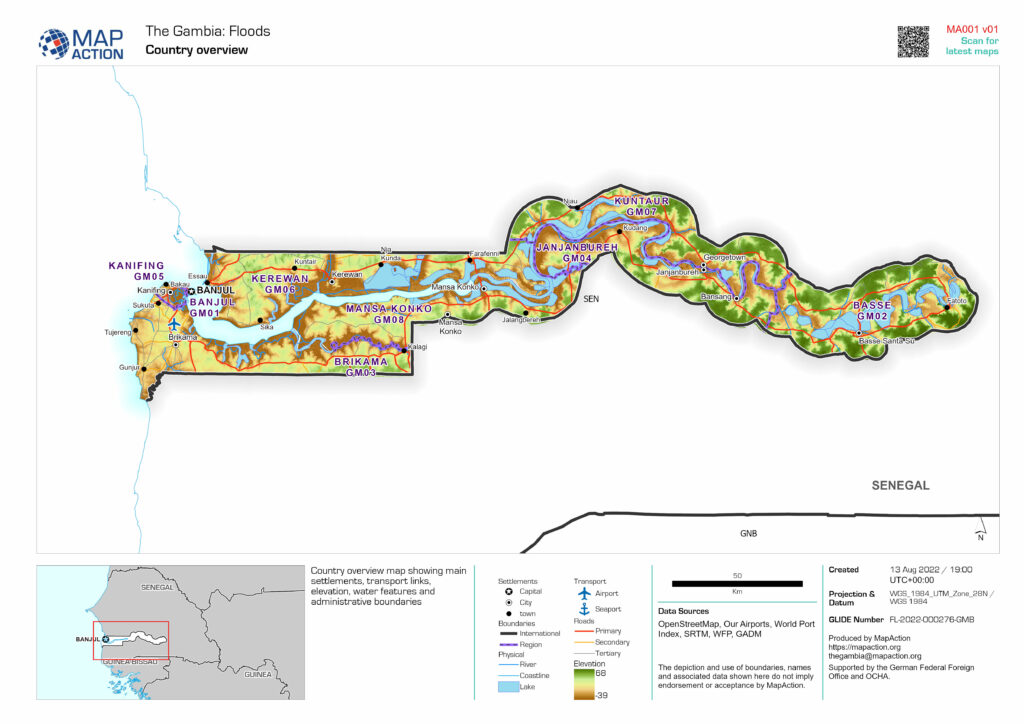
Heavy rainfall in recent weeks has affected the majority of the country (particularly the West Coast, North Bank and the Greater Banjul areas), causing significant floods and flash floods which have resulted in casualties and widespread damage.
Recently, the country has experienced the heaviest rainfall in decades, which is affecting most areas. The resulting floods have caused multiple casualties and widespread damage to buildings and infrastructure. Some people have been displaced and many families are in need of urgent assistance.
As a low lying country, dominated by the Gambia River, Gambia is highly vulnerable to the impacts of climate change, such as sea level rise and an increase in rainfall and temperatures, leading to droughts and floods. These are affecting the country’s economy, including the agricultural sector which is dominated by rain-fed agriculture, as well as the tourism sector.
MapAction will be supplying situational data analysis, visualisation and geospatial expertise. A remote team will also be helping with data gathering and map generation. This will support coordination and aid delivery decision-making.
Find our latest maps and data on this emergency when prepared here.
MapAction team members get ready for deployment through our annual disaster simulation exercise
In June MapAction volunteers from all over the world headed to Gloucestershire for their biggest deployment team training event in the calendar.
These simulations are a chance to practise many of our standard operating procedures, and an opportunity to build team cohesion.
This year’s simulation focused on reinforcing field skills and rapid analysis whilst operating with limited connectivity in a demanding setting. The scenario took place in a fictional country, where an ongoing 15-month drought was causing food insecurity. A sudden migration event tipped this into an emergency and triggered a MapAction ‘deployment’ in support of an alliance of international and national NGOs.
As with previous simulations, facilities were deliberately basic and participants had to camp. One night also involved an overnight stay in work areas as venturing outdoors was deemed to be ‘currently unsafe’ within the scenario. Team members might encounter such insecurity on a field deployment.
For MapAction Volunteer Alice Goudie, who joined us in 2018, the training was a good opportunity for her to test out some of the skills she’s picked up on deployment:
“GIS skills are only part of what we do, a lot of the skills are more to do with working in harsh environments, communicating, and working under pressure.”
Alice has been on a number of deployments with us but knows that each situation is a learning experience,
“In the four years that I have been deployable I have been on an International Search and Rescue Advisory Team (INSARAG) mission to Armenia, two emergency deployments to The Bahamas and Madagascar, one emergency deployment which ended up being remote for Equatorial Guinea, and I’ve done two remote covid projects in Libya and Kenya and worked on a CSO project in Nepal and Indonesia.“
Laverne Rogers volunteers for MapAction’s Caribbean section. She normally works as a GIS Manager for the Government of Montserrat. She was inspired to join MapAction following the devastation that hurricanes Irma and Maria brought to the Caribbean. She recently deployed to support one of our partners, CDEMA, following a volcano eruption in St. Vincent and the Grenadines.
Our training events are also a time where we can mentor and develop new team leaders in a safe but challenging environment.
For this simulation exercise, Laverne had the opportunity to be a Team Leader:
“I learnt how to manage a team during a disaster response, understanding safety and security requirements for the team and also being able to understand the situation on the ground in order to provide suitable support to our partners and guide the team members to do that.”
After two weeks in Madagascar responding to multiple cyclones MapAction’s humanitarian mapping team flew into Heathrow on Wednesday February 23. They had a handover meeting with our next team who are now en-route to Madagascar to replace them. Normally these handovers are in-country but travel challenges mean it was impossible this time.
They will join up with the United Nation Disaster Assessment and Coordination (UNDAC) surge capacity team in Nairobi and fly to the island of Reunion, working from there for a while before joining the wider UN team in Madagascar until 6 March.
Madagascar is still reeling from storms Ana and Batsirai and has now been hit by yet another tropical cyclone – Emnati. The MapAction team will continue to provide situational data analysis, data visualisation and geospatial expertise. The crises will continue to be supported by a remote MapAction team in the UK who will gather, process and check data and create products.
MapAction has mobilised a team to support the humanitarian response following Storm Batsirai, which hit Madagascar on Saturday evening. The team is due to leave on Tuesday.
Batsirai, a category three cyclone, swept away cars and houses, causing loss of life, flooding, landslides, destruction of infrastructure. It arrived with the country still reeling from Storm Ana which killed 55 people just weeks ago.
The scale of the situation is still emerging and MapAction’s team will help with that task. However media reports indicate that 250,000 people have been affected, more than 50,000 may be displaced and at least 10 people are known to have died so far. Many more may be affected as river levels are continuing to rise.
The United Nations Disaster Assessment and Coordination team (UNDAC) have requested MapAction’s situational data analysis, visualisation and geospatial expertise. MapAction will deploy a two person team to Kenya from where they will be able to enter Madagascar. We will then assess the situation and decide whether additional support might be necessary.
MapAction’s services are in ever more demand because of the increase in climate related events, be they food, infrastructure or conflict related. Although these events can’t be stopped, we can help mitigate the effects of these events and are actively working towards this goal.
“Alert Check: Volcanic Eruption St Vincent and the Grenadines, please sign up your availability.” Those were the words which greeted me as I checked my MapAction email. Simple words, but so profound for me. They really hit hard, and hit home! I could not ignore that call for action. I signed up for remote deployment. It turned out to be my first official response deployment as a MapActioner!
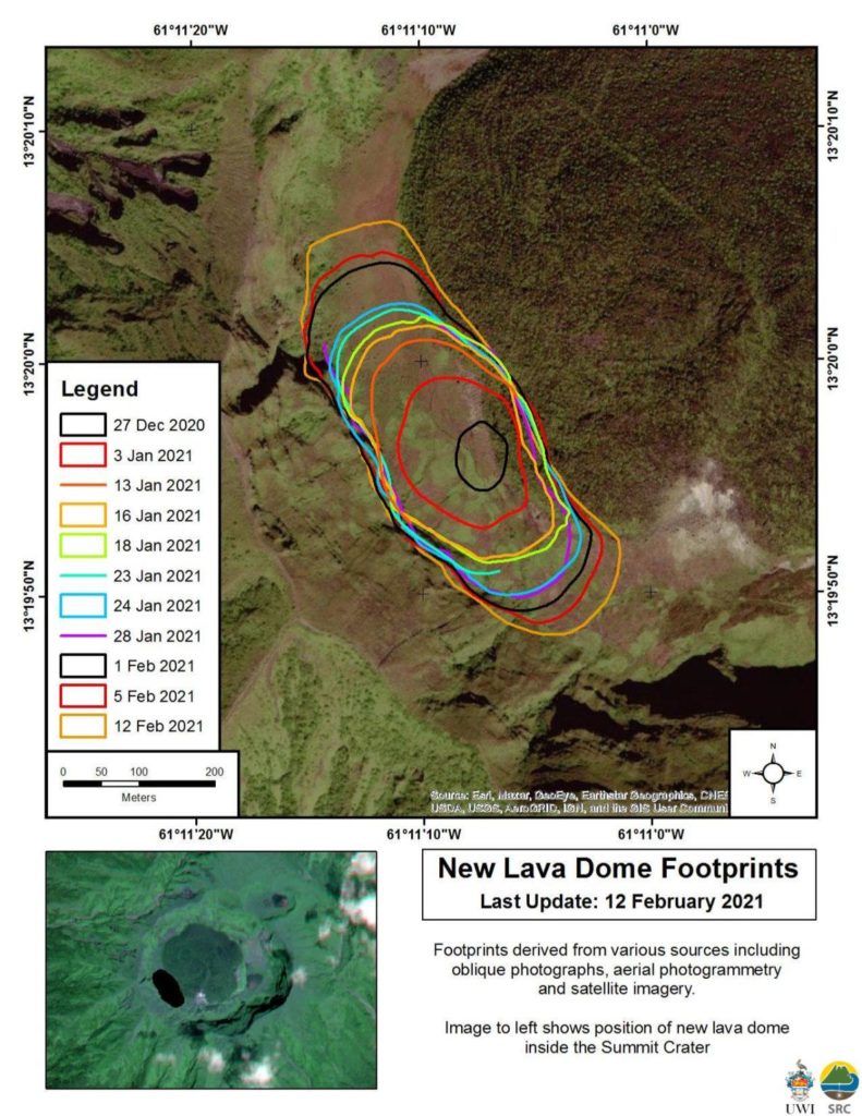
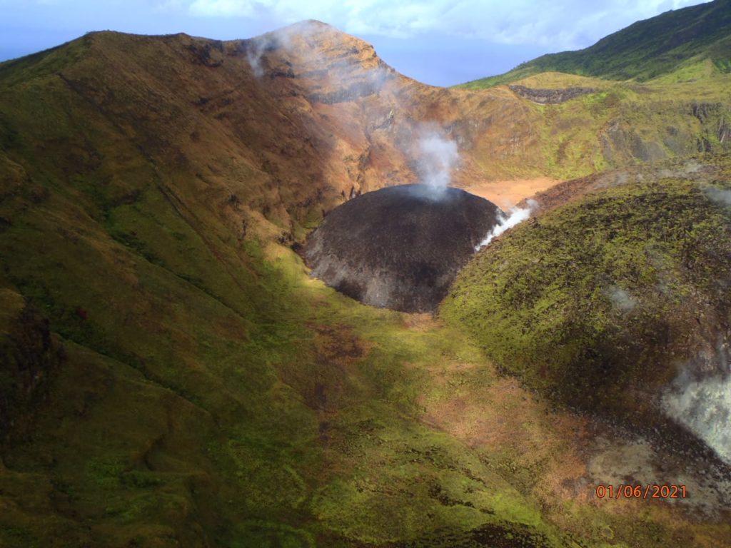
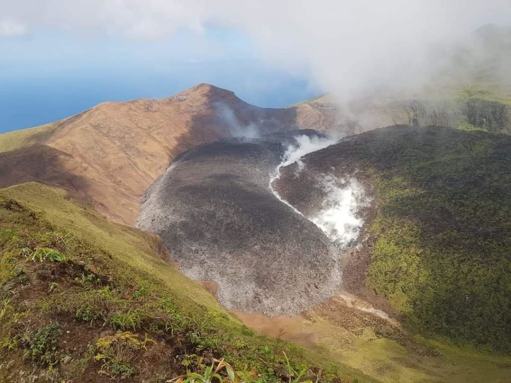
Like many people within the region, I have been observing the volcanic dome growth in St Vincent and the Grenadines since late 2020. As it grew, magma continued to fill the space around the old 1979 dome, as depicted in the images below.
Source: Scientific Resource CentrePhoto credit: NEMO, St. Vincent and the GrenadinesPhoto credit: NEMO, St. Vincent and the Grenadines
A period of elevated volcano-tectonic (VT) earthquakes, which began on 23rd March, 2021, indicated to scientists that the situation at La Soufrière had deteriorated. An evacuation order was issued on April 8, 2021 by Prime Minister Ralph Gonsalves.
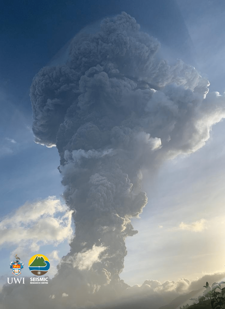
The very next day, on April 9, 2021, La Soufrière Volcano erupted! The eruption was very visible to people around the world due to the prominence of posts on social media. It was easy to see live feeds and video posts as the action unfolded. Images of the massive mushroom plume created by the eruption brought back so many memories for me. It was beautifully dangerous!
Having experienced the eruption of our very own Soufrière Hills Volcano in Montserrat and having lived with an active volcano for the past two decades, I empathised with the residents of St Vincent and the Grenadines. Being displaced from one’s home to live in a shelter is no easy feat. Having to leave behind the beloved island you call home is even more challenging. I knew the road ahead for many people would be long and difficult. Hence my conviction to help in the best way I knew: – by providing geospatial support.
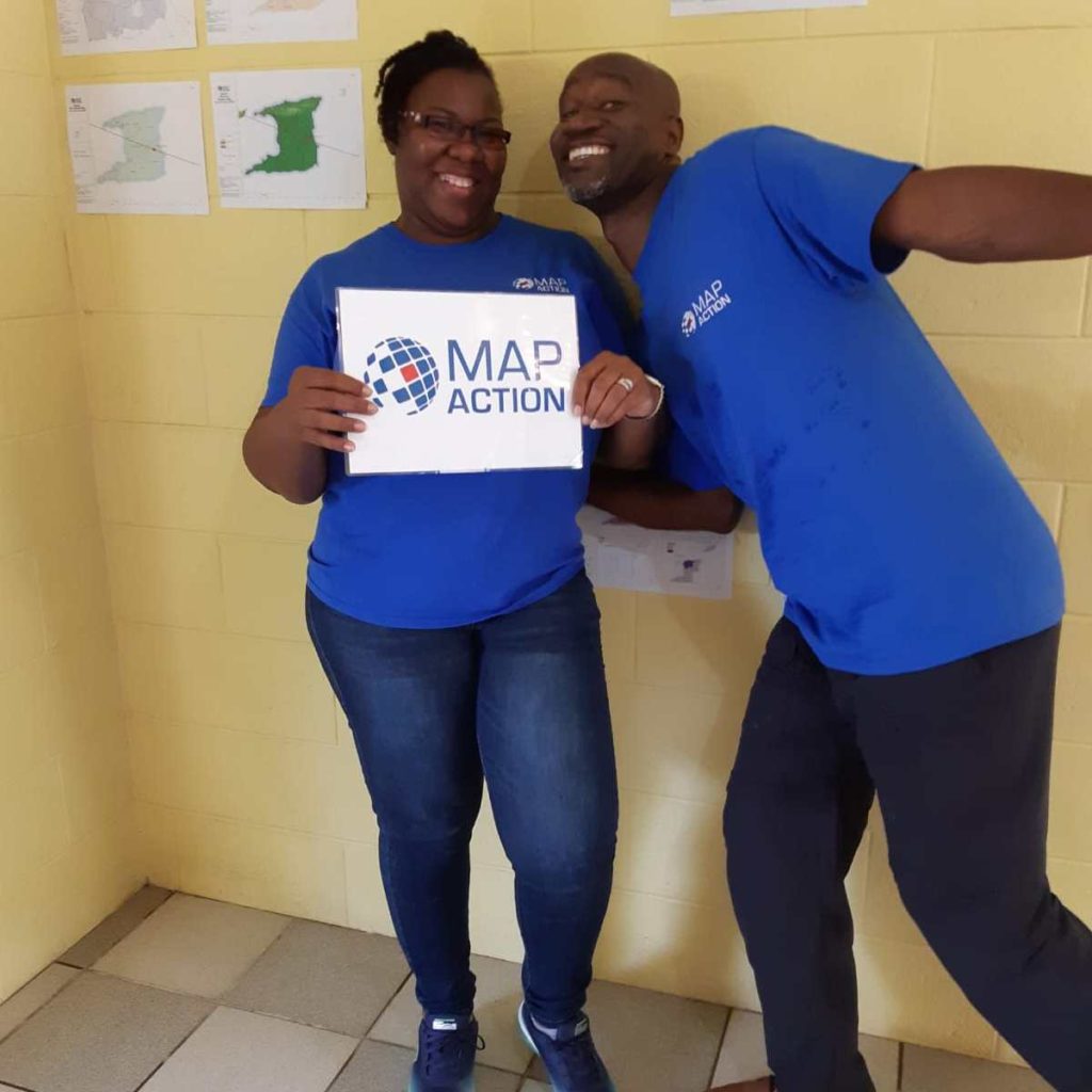
It was great news to discover that Mike was also selected as a member of this remote deployment team for the St. Vincent Response. Mike and I were recruited at the same time in 2019 to form part of the Caribbean Section of MapAction. The picture below is a throw-back to June 2019 in Trinidad. We had several days of intense conversion training sessions. In retrospect, those days really set the foundation for our ability to deliver during this response.
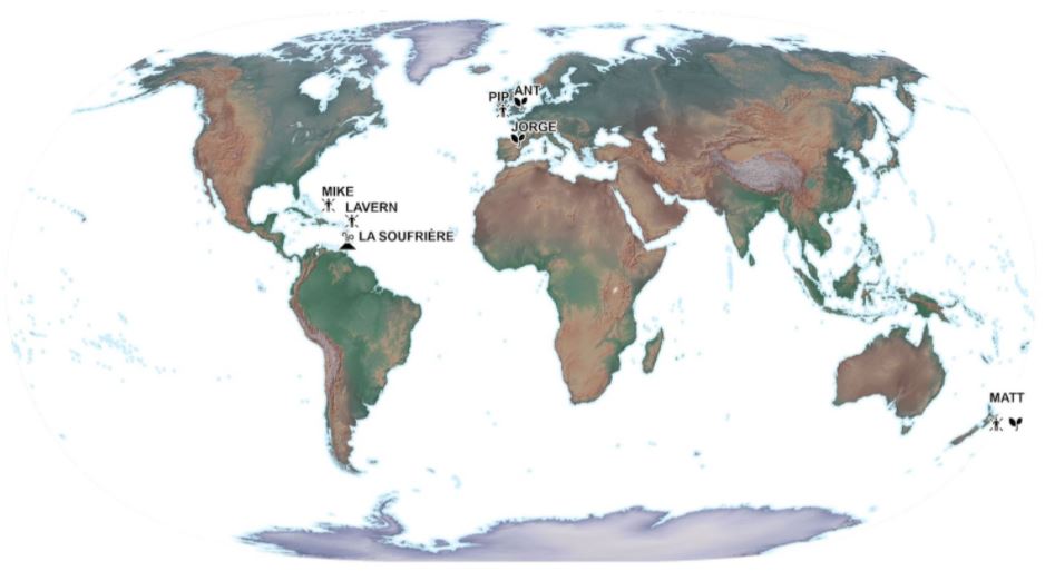
Our team was led by Matt who resides in New Zealand. He is very knowledgeable and has significant experience in deployments. We also received additional support from another volunteer, Pip, who is located in the UK. We supported the Caribbean Disaster Emergency Management Agency (CDEMA) for a period of three weeks. Subsequently, another two volunteers, Ant and Jorge, were deployed to support the environmental work of the United Nations Environment Programme’s (UNEP) response. We represented different time zones and locations from across the globe.
This unique team selection, worked out very well, as it offered 24 hour coverage for the St. Vincent response. Mike and I, being located in the Caribbean region, were uniquely placed to attend briefing meetings in our local time zone and follow up with any new developments; while Matt provided another level of support from New Zealand, as his day began when ours was coming to an end. No sleep lost – I guess! Our daily briefing meetings allowed us to report our findings during that day and to strategise the allocation and completion of tasks.
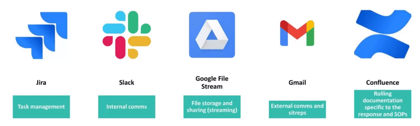
MapAction has mastered the ability to use different tools to share and work together in a remote working environment. In my opinion, the COVID-19 pandemic has only strengthened this area. The image below highlights some of the main tools we used to ensure smooth deployment coordination.
One of the major needs of any emergency response is geospatial data. The ‘data scramble‘ as the term is coined, involves the researching, collating and organising of all the spatial data available for a particular location, ensuring that it is fit for purpose. The data collected was prepared by transforming it into the correct projected coordinate system to allow for overlay and integration between different datasets. Datasets included administrative boundaries, such as parishes, census districts, shelter locations, elevation data, transportation networks, buildings, land use, hazard zones, and health centres, just to name a few. These were placed in appropriately themed folder locations so that it would be easy for deployed members to find them during the response.
Coordinating with CDEMA, MapAction provided mapping support to to aid in visualisation of the situation on the ground.
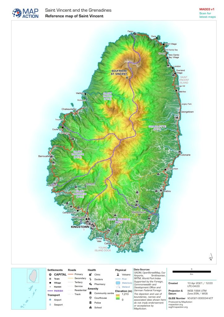
One of the first maps prepared is a reference map of the area. I consider this to be one of the most important maps to be prepared, as it gives context to the area of interest. Everything else is built upon this.
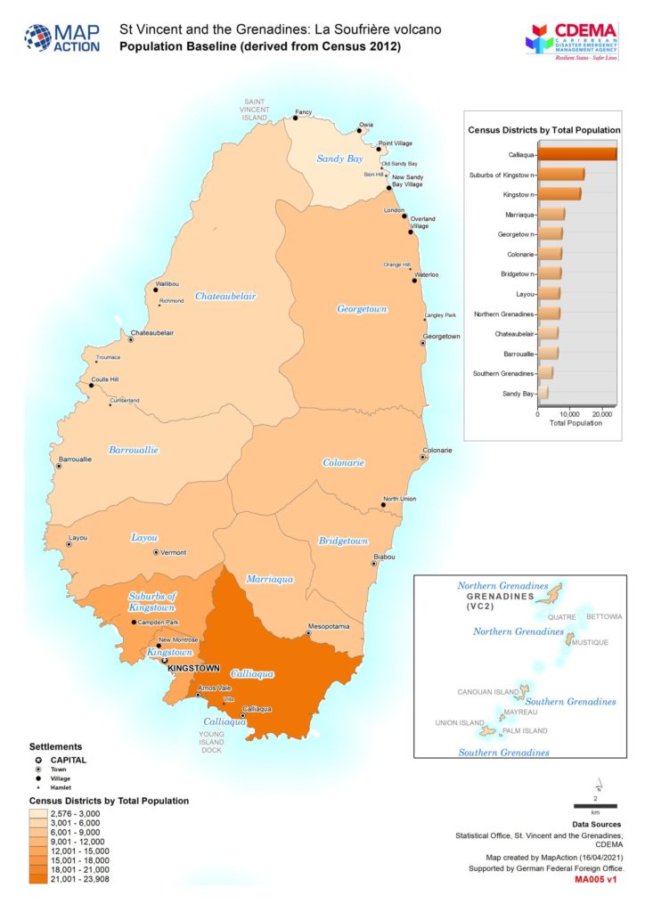
The basemap shown on the left below is detailed with settlement locations, roads, parishes, village names, rivers and elevation data. The baseline map sown on the right, highlights the population figures of St.Vincent derived from the most recent 2012 census survey. This allowed us to understand how the population is distributed throughout the affected areas.
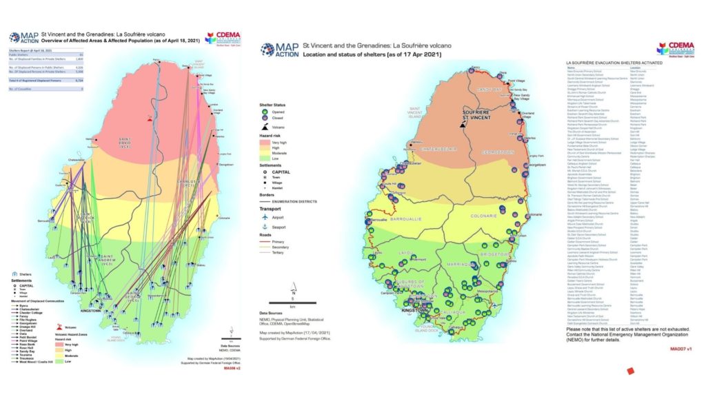
To provide further understanding, situational maps were prepared. Data being shared through situation reports from the Emergency Management Agency allowed us to create visual representations of what was happening on the ground. The map on the left, shows movement of displaced people from affected communities in the red, orange and yellow zones. The map on the right shows the location and status of the shelters.
Additionally, a 3D webmap was created showing the key volcanic events and hazards of the La Soufrière volcano. This dynamic map allows you to explore the data which was used to create the maps above and offers a better understanding of the risk posed by the volcanic eruption in St. Vincent.
3D webmap showing volcanic hazards
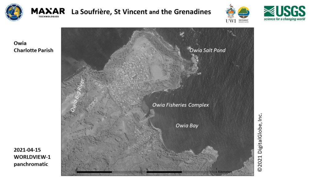
Working so closely with the data from St. Vincent during this period of time, allowed me to become very familiar with areas and village locations on the island. Seeing feeds on social media allowed me to identify quickly with where things were happening. Names such as as Chateaubelair, Troumaca, Byera, Owia and Fancy stood out to me!
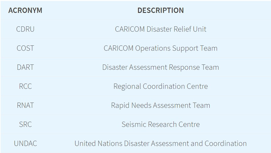
During my remote deployment, some acronyms were mentioned frequently during our briefing meetings. I eventually got the hang of them! These all form part of the response mechanism which helps the crisis on the ground to be addressed. Each of the teams highlighted below, played a very important function in being able to get supplies into St. Vincent, assessing the needs of the population and understanding the impact of the disaster on the island.
A number of other international organisations responded to the crisis in St Vincent and the Grenadines by activating their disaster response mechanisms and programmes. The links below provide additional insight into their response activities.
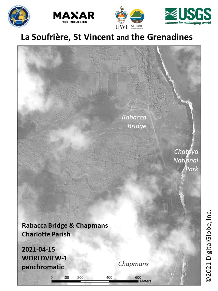
Satellite images like the ones below were captured as time progressed and further mapping and analysis was carried out. Derived information proved useful to responders on the ground.
MapAction is known to respond in-person during an emergency response deployment. Although the COVID-19 pandemic has limited this, my experience through this remote response deployment has shown that MapAction’s involvement is still significant in providing geospatial information to support the humanitarian needs of people in crisis. I do look forward to future deployments with MapAction!
This article was first published on Lavern’s own blog on 24 May 2021.
In this video, MapAction volunteer Emerson Tan gives a report from the airport on his way home from Guatemala.
MapAction was mobilised to help the international response to the catastrophic impacts of Hurricanes Eta and Iota which have caused tremendous suffering across Central America, on top of the COVID pandemic.
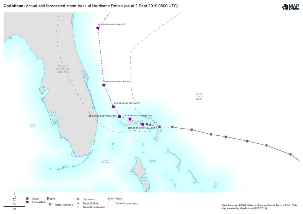
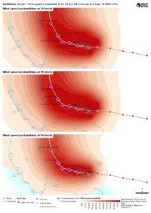
A MapAction team is en route to the Bahamas to support the Caribbean Disaster Emergency Management Agency (CDEMA) and the UN Office for the Coordination of Humanitarian Affairs (UNOCHA) as they coordinate the response to Hurricane Dorian. Our UK support base has already been working over the weekend on vital maps and data.
With windspeeds over 160mph, the category 5 Hurricane is the strongest to hit the Bahamas since records began. It is moving slowly westards across the Abaco Islands and Grand Bahama.
We are grateful to the UK’s Department for International Development (DFID) and the Netherlands Ministry of Foreign Affairs for enabling us to help provide the geospatial input that’s needed to get aid to where it’s most needed as quickly as possible.
MapAction volunteer Andreas Buchholz has just returned from Beira, Mozambique. He has put together the short video below, which gives a good sense of the scale and urgency of the international response to this major disaster.
While the
floodwaters have begun to recede, the situation is still very serious in large
parts of Mozambique and surrounding countries. Damage to homes and livelihoods
is extensive and lack of access to clean water is causing outbreaks of diseases
such as cholera.
MapAction has been working closely with the government of Mozambique, NGOs, the UN and Red Cross teams at the heart of the response and our help has been widely appreciated. The aerial assessment maps shown in the video have so far been printed over two thousand times and used to support search and rescue and the distribution of foodstuffs. The maps were created by the MapAction team in Mozambique with close collaboration with the International Federation of Red Cross and Red Crescent Societies, the UN Office for the Coordination of Humanitarian Affairs (UNOCHA) and Save the Children.
At the time of writing, MapAction personnel are continuing to work at the On-Site Operations Coordination Centre in Beira, Mozambique.
We are grateful to everyone that has donated to our Cyclone Idai appeal, to the UK’s Department for International Development (DFID) and to the Netherlands Ministry of Foreign Affairs for funding this life-saving work.
On Friday 14 March, Cyclone Idai made landfall along the south-eastern coast of Africa. With sustained wind speeds of 120mph and heavy rain, it is now recognised as one of the most intense recorded weather events to hit the region. Many affected areas were already heavily waterlogged, making the overall effect even worse and causing extensive flooding.
Hundreds of people are known to have died and hundreds of thousands of people to have been affected, with casualties across Malawi, Mozambique, Zimbabwe and Madagascar. Many people have been left without shelter, clean water or food.
MapAction initially sent a three-person Emergency Response Team to Mozambique on 20 March at the request of United Nations Disaster Assessment and Coordination (UNDAC) Team. A fourth team member followed a few days later when it became clear that more in-country support was needed. Three MapAction members are currently based in Beira, the city that took the full brunt of the Cyclone, suffering catastrophic damage, and a fourth is in Chimoio, to the West of Mozambique. A further team rotation will travel out this weekend.
MapAction’s highly specialist team is working at the heart of the planning and coordination of the response, providing vital situation maps and information management services needed by all agencies to get help to where it’s most needed, as quickly as possible.
Among other things, the MapAction team in Mozambique is providing analysis of aerial assessments of the affected area, working with UNOCHA, the Red Cross and Save the Children. Photo by Luke Caley
They are supported in this work by our wider team of technical volunteers and specialist staff, who have been working remotely on flood extent modelling and on gathering and sharing useful reference data to help response teams since the disaster happened.
We are grateful to everyone that has donated to our Cyclone Idai appeal, to the UK’s Department for International Development (DFID) and to the Netherlands Ministry of Foreign Affairs for funding this life-saving work.
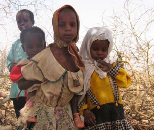
DAKAR, 9 Feb – A severe food crisis is forecast to strike the Sahel region of West Africa later in 2012, potentially affecting 7 to 10 million people in eight countries (Senegal, Mauritania, Mali, Burkina Faso, Niger, Nigeria, Chad and Cameroon). Low rainfall, poor harvests and high food prices are making communities vulnerable to extreme malnutrition. The number of children dying from nutrition-related causes is already estimated at more than 490,000 per year.
MapAction has deployed a team of two volunteers to undertake a mapping preparedness project from the UNICEF regional office in Dakar, Senegal. The team will work with UNICEF information management staff to do preparatory map setup and initial vulnerability maps, with a focus on food security and nutrition.
This is MapAction’s third deployment to the Sahel region. In 2005, our volunteers helped map priority needs in a food crisis in Niger and in 2009 we responded to floods in Burkina Faso.


 DAKAR, 9 Feb – A severe food crisis is forecast to strike the Sahel region of West Africa later in 2012, potentially affecting 7 to 10 million people in eight countries (Senegal, Mauritania, Mali, Burkina Faso, Niger, Nigeria, Chad and Cameroon). Low rainfall, poor harvests and high food prices are making communities vulnerable to extreme malnutrition. The number of children dying from nutrition-related causes is already estimated at more than 490,000 per year.