A year of collaboration with the Centre for Humanitarian Data

Headshot of Hannah Ker outdoors

By Hannah Ker, Data Scientist at MapAction

In March 2020, MapAction and the UN OCHA (Office for the Coordination of Humanitarian Affairs) Centre for Humanitarian Data embarked on a new level of collaboration by sharing a Data Scientist’s time between the two organisations. Both teams had a lot to offer and learn from each other, with MapAction bringing its geospatial expertise to the Centre’s Predictive Analytics (PA) team. Predictive analytics is a form of data science that uses current and historical facts to predict future events. For MapAction, this collaboration also constituted an important aspect of our Moonshot, which sees us transitioning from being a passive data consumer to an organisation that actively contributes to humanitarian datasets.

2020 Highlights

Looking back on our work over the past year, we can see how this collaboration has benefitted both organisations in many ways, with numerous positive repercussions more widely. Ultimately, the fruits of our joint working are examples of how data science can help to reduce suffering and save lives in humanitarian initiatives. 

Your input leap-frogged us forward. It is amazing to me how quickly we were able to do this together. A round of applause for your work and its contribution to unlocking critically needed aid for Ethiopians.

Josée Poirier, Predictive Analytics Technical Specialist, Centre for Humanitarian Data

Preventing hunger

In the latter part of the year, a MapAction team of volunteers helped the Centre’s PA team develop analysis for a drought-related anticipatory action framework which was designed to trigger mitigation activities ahead of a predicted drought crisis. The PA team aimed to better understand the reliability of various indicators used to predict potential food shortages caused by drought in Somalia and Ethiopia. These indicators were then used to trigger an early release of funds from the UN’s Central Emergency Response Fund (CERF). The MapAction team reviewed past literature, evaluated available satellite images, and created a prototype drought model in Google Earth Engine (a platform for visualising and analysing satellite imagery of Earth). These inputs helped the PA team to flag an upcoming crisis in Ethiopia and trigger an activation for a humanitarian response. In the words of Josée Poirier, Predictive Analytics Technical Specialist from the PA team: “Your input leap-frogged us forward. It is amazing to me how quickly we were able to do this together. A round of applause for your work and its contribution to unlocking critically needed aid for Ethiopians.”

Flood mapping

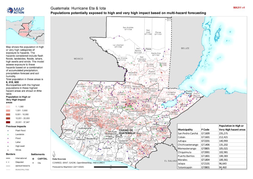
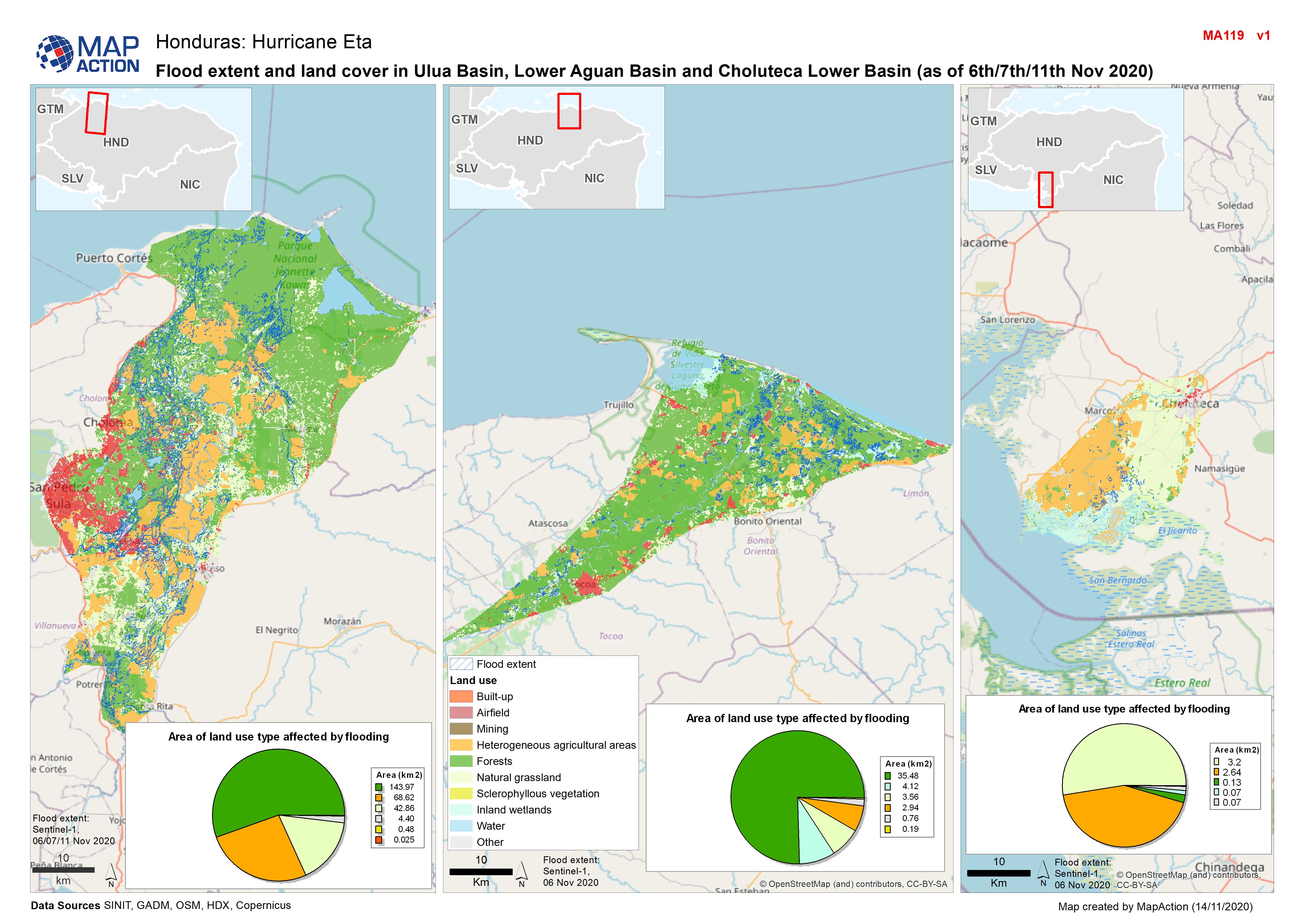
The MapAction and PA teams also collaborated to implement and validate an approach for mapping flooding from satellite imagery. MapAction’s Data Scientist has been working with the PA team to help evaluate the impact of recent anticipatory action in Bangladesh which took place in July 2020 and was the fastest-ever allocation of CERF funds. To better understand how this aid was helpful to those affected, the PA team needs to know exactly when, where, and for how long flooding occurred. Contributing to this work also has direct benefits for MapAction’s own work, enabling us to add a new data processing method to our disaster-response toolbox. We then had the opportunity to test this methodology in our response to the devastating impacts of Hurricanes Eta and Iota in Central America. 

MapAction was able to test the flood-mapping methodology developed with the Centre for Humanitarian Data in the response to Hurricanes Eta and Iota in Central America. Photo: European Union, 2020 (D Membreño)

COVID-19

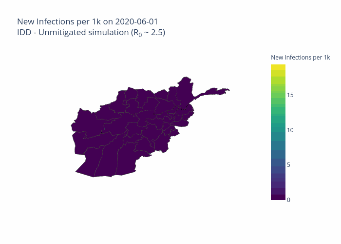
Both organisations have made commitments to assist in the global pandemic response. The Centre PA team and MapAction Data Scientist have, in partnership with the Johns Hopkins University Applied Physics Laboratory (APL), developed a model to forecast the number of cases, hospitalisations, and deaths due to COVID-19 for six countries, tailored to each country’s specific humanitarian needs. Named OCHA-Bucky, the model offers sub-national projections, and takes into the account the effects of non-pharmaceutical interventions. Presently, MapAction is participating in a pilot project to aid vaccine rollout in vulnerable countries by surveying the current data landscapes and identify gaps in order to address the logistical challenges inherent in such tasks. Along a similar line of work, the Centre PA team and APL are planning on adding vaccination strategies to the OCHA-Bucky model. 

animation of new COVID infections model in Afghanistan
Projected total infections per 100,000 inhabitants in Afghanistan on 2020-08-03. Projections were obtained by simulating local transmission in each district in Afghanistan and expected spatial and temporal spread between districts. Country-specific risk factors were included in the simulation at the subnational level.

Shared goals

There is substantial overlap between the broad technical goals of the two organisations. The Centre’s Humanitarian Data Exchange (HDX) contains over 18,000 datasets and it has created several automatic pipelines (software that carries out a series of data-processing steps) to systematically ingest data from its partners into its database. The Centre’s technical expertise has so far been a key input into the planning and development of a similar (albeit smaller scale) pipeline at MapAction, which is being created to automate the generation of core maps as part of the Moonshot initiative. This work will ensure that base maps essential for coordinating any type of humanitarian response are immediately available whenever they are needed. 

The two organisations share similar data access platforms and are actively engaged in ongoing discussions regarding different ways to construct pipeline software. Finally, both HDX and MapAction ultimately seek to identify and rectify gaps in the humanitarian data landscape in order to ensure that those coordinating the preparations for and responses to different types of emergencies have the reliable, timely information they need. 

Looking ahead in 2021

MapAction and the Centre for Humanitarian Data are continuing to plan ways to collaborate throughout the rest of the year and beyond. 

In addition to sharing expertise in advanced analytics, we are working to make data-driven methods accessible to wider audiences in the humanitarian sector in order to improve the effectiveness of aid programmes. MapAction and the Centre’s Data Literacy team have identified an opportunity to come together to develop GIS training material. This work aims to help non-technical humanitarians make better use of geospatial data to understand the needs of affected communities and coordinate aid. 

Both teams are also collaborating to ensure that our data science workflows and models are published openly and can be used by others in the field. Inspired by initiatives such as The Turing Way, we are formalising and adopting best practices to write high quality code, document methodologies, and reproduce results. 

German Humanitarian Assistance logo

At the end of the first year of our collaboration, it is gratifying to reflect on how much we have been able to achieve together while learning from each other and expanding our collective knowledge. We’re grateful to the German Federal Foreign Office for making this work possible by funding our Data Scientist role. We’re looking forward to continuing to work together to push forward the boundaries of humanitarian data science.

Guatemala – video report from the airport

In this video, MapAction volunteer Emerson Tan gives a report from the airport on his way home from Guatemala.

MapAction was mobilised to help the international response to the catastrophic impacts of Hurricanes Eta and Iota which have caused tremendous suffering across Central America, on top of the COVID pandemic.

Emergency support for hurricane-hit Guatemala

A three-person MapAction team is today travelling to Guatemala following extreme flooding and catastrophic landslides in 12 of 22 of the country’s administrative departments caused by Hurricanes Eta and Iota. Ten departments have declared a state of emergency and the Guatemalan government has requested foreign assistance. Around one million Guatemalans are estimated to be directly affected and at least 53 people are known to have died.

The devastating storms have come on the back of social and economic hardship caused and exacerbated by COVID, unemployment and population displacement. The flooding has caused widespread destruction of crops and livestock and around 5,000 wells have been contaminated. There is a high risk of disease outbreak and many people are in urgent need of shelter.

Map of Guatemala showing populations potentially exposed to high and very high impact based on multi-hazard forecasting

The MapAction team, which is deploying at the request of the Office for Coordination of Humanitarian Affairs (OCHA), will be helping to gather and map information about the evolving situation on the ground, as well as the aid being provided by different agencies, so that gaps can be identified and addressed.

This mission brings the total number of MapAction personnel working with OCHA teams on the impacts of Eta and Iota in the Central American region to nine, with additional support from across our wider team. In addition to the Guatemalan team, a five-person MapAction team has been providing full remote emergency support to OCHA’s Regional Office for Latin America and the Caribbean (ROLAC) since 6 November and another team member has been seconded to ROLAC full time since September to assist with hurricane preparedness and other humanitarian issues across the region.

We’re grateful to the German Federal Foreign Office for supporting our response, as well as to the Netherlands Ministry of Foreign Affairs, the UK FCDO and Rotary clubs around the UK for their continued support of MapAction’s response capacity. 

Responding to Hurricanes Eta and Iota

Countries in Central America are facing catastrophic winds and flooding as Hurricane Iota, a Category 5 storm, makes its way across Nicaragua, Honduras and El Salvador.

With wind gusts of up to 250km/hr and torrential rain, Iota made landfall in northeast Nicaragua last night. It is compounding the damage and devastation inflicted by Category 4 Hurricane Eta, which killed at least 178 people in the region a fortnight ago and destroyed food crops for thousands of families.

Map of flood extent and land cover in Ulua Basin, Lower Aguan Basin and Choluteca Lower Basin, Honduras, as of 6th/7th/11th November 2020

MapAction has been remotely providing full emergency support to the Latin American and Caribbean regional body of the UN’s Office for Coordination of Humanitarian Affairs (OCHA), known as ROLAC, since 6 November to assist the response to Eta and now Iota. This includes mapping storm tracks, flood extents, building damage, affected populations and information about what assistance humanitarian teams are already providing in different locations so that gaps can be identified and rapidly addressed. This work represents a scaling-up of the ongoing support to ROLAC we have been providing since September, in preparation for Hurricane season and other humanitarian issues across the region.

“Iota is hampering the response to Eta, severely degrading logistic routes and complicating the information picture,” said MapAction’s Operations Director Chris Davies. “Our maps are helping teams on the ground direct resources where they’re most needed, as safely as possible. We will continue to provide support to our ROLAC colleagues and are anticipating and preparing for additional requests for our assistance.”

Map of humanitarian presence overview by department, Honduras, as at 16 November 2020

We’re grateful to the German Federal Foreign Office for supporting our response, as well as to the Netherlands Ministry of Foreign Affairs and the UK FCDO for their continued support of MapAction’s response capacity. 

Responding to floods in Djibouti

Two MapAction volunteers are travelling to Djibouti, East Africa, tomorrow at the request of the UN Disaster Assessment and Coordination (UNDAC) to assist the response to devastating floods that have affected up to 250,000 people.

Flash floods occurred when two years’ worth of rainfall fell in a single day on top of several days of heavy downpours. Nine people are believed to have died, including seven children, and more rain is forecast. Most of those affected are in Djibouti city, the country’s capital.

The Djibouti government is leading the relief operation with the support of humanitarian partners, civil society and armed forces stationed in the country. MapAction is providing reference and situational maps to assist the coordination of the response.

MapAction’s team is likely to remain in Djibouti for around two weeks, but this will be reviewed at that time. Direct mission costs are being met by the German Federal Foreign Office. MapAction’s deployment capacity is funded by UK Government DFID and Government of Netherlands Ministry of Foreign Affairs.

Responding to floods in Lao PDR

At the end of August and beginning of September, Tropical Storm PODUL and Tropical Depression KAJIKI caused heavy rain in the Lao People’s Democratic Republic. This resulted in flooding in six provinces in the southern part of the country. 1,658 villages across 47 Districts have been affected.

A MapAction volunteer is currently working in the Association of Southeast Asian Nations (ASEAN) Emergency Operations Centre in Jakarta to support our partner the AHA CENTRE as they assist the response. He is supporting the Emergency Response Assessment Team by mapping the evolving situation on the ground, conducting geospatial analysis to compare with 2018 flash flooding in the region, and helping to identify gaps in coverage to help get aid where it’s most needed. This also involves establishing information management and GIS systems and templates for Lao that will be useful beyond the current emergency.

We’re very grateful to the German Federal Foreign Office for supporting this work.

Inside the Response to Cyclone Idai

MapAction volunteer Andreas Buchholz has just returned from Beira, Mozambique. He has put together the short video below, which gives a good sense of the scale and urgency of the international response to this major disaster.

While the floodwaters have begun to recede, the situation is still very serious in large parts of Mozambique and surrounding countries. Damage to homes and livelihoods is extensive and lack of access to clean water is causing outbreaks of diseases such as cholera.

MapAction has been working closely with the government of Mozambique, NGOs, the UN and Red Cross teams at the heart of the response and our help has been widely appreciated. The aerial assessment maps shown in the video have so far been printed over two thousand times and used to support search and rescue and the distribution of foodstuffs. The maps were created by the MapAction team in Mozambique with close collaboration with the International Federation of Red Cross and Red Crescent Societies, the UN Office for the Coordination of Humanitarian Affairs (UNOCHA) and Save the Children.

At the time of writing, MapAction personnel are continuing to work at the On-Site Operations Coordination Centre in Beira, Mozambique.

We are grateful to everyone that has donated to our Cyclone Idai appeal, to the UK’s Department for International Development (DFID) and to the Netherlands Ministry of Foreign Affairs for funding this life-saving work.

MapAction supports Cyclone Idai response

On Friday 14 March, Cyclone Idai made landfall along the south-eastern coast of Africa. With sustained wind speeds of 120mph and heavy rain, it is now recognised as one of the most intense recorded weather events to hit the region. Many affected areas were already heavily waterlogged, making the overall effect even worse and causing extensive flooding.

Hundreds of people are known to have died and hundreds of thousands of people to have been affected, with casualties across Malawi, Mozambique, Zimbabwe and Madagascar. Many people have been left without shelter, clean water or food.

MapAction initially sent a three-person Emergency Response Team to Mozambique on 20 March at the request of United Nations Disaster Assessment and Coordination (UNDAC) Team. A fourth team member followed a few days later when it became clear that more in-country support was needed. Three MapAction members are currently based in Beira, the city that took the full brunt of the Cyclone, suffering catastrophic damage, and a fourth is in Chimoio, to the West of Mozambique. A further team rotation will travel out this weekend.

MapAction’s highly specialist team is working at the heart of the planning and coordination of the response, providing vital situation maps and information management services needed by all agencies to get help to where it’s most needed, as quickly as possible.


Among other things, the MapAction team in Mozambique is providing analysis of aerial assessments of the affected area, working with UNOCHA, the Red Cross and Save the Children. Photo by Luke Caley

They are supported in this work by our wider team of technical volunteers and specialist staff, who have been working remotely on flood extent modelling and on gathering and sharing useful reference data to help response teams since the disaster happened.

We are grateful to everyone that has donated to our Cyclone Idai appeal, to the UK’s Department for International Development (DFID) and to the Netherlands Ministry of Foreign Affairs for funding this life-saving work.

[Update: video blog ‘Inside the response to Cyclone Idai]

Responding to floods in Nigeria

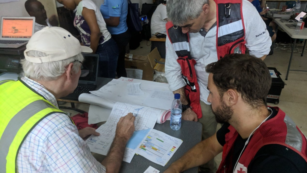
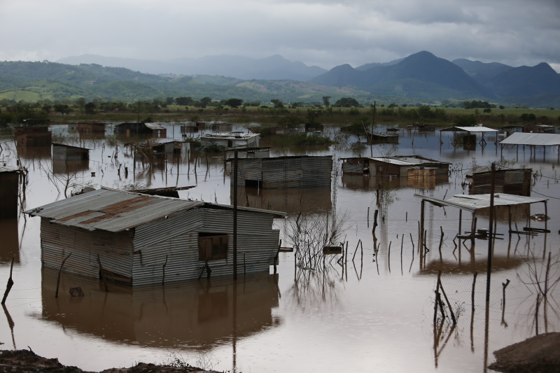
Severe floods in Nigeria have claimed almost 200 lives and affected over 80% of the country across 12 states. For the past week, a two-person MapAction team has been in Abuja supporting the UN Disaster Assessment and Coordination Team and the National Emergency Management Agency in their response.

MapAction has been helping with information management and needs assessments for critical food, water, shelter and healthcare supplies to ensure those affected get the help they need as quickly as possible. We’re grateful to the UK Department for International Development (DFID) for funding this essential work.