MapAction Madagascar teams handover at Heathrow 

After two weeks in Madagascar responding to multiple cyclones MapAction’s humanitarian mapping team flew into Heathrow on Wednesday February 23. They had a handover meeting with our next team who are now en-route to Madagascar to replace them. Normally these handovers are in-country but travel challenges mean it was impossible this time.

They will join up with the United Nation Disaster Assessment and Coordination (UNDAC) surge capacity team in Nairobi and fly to the island of Reunion, working from there for a while before joining the wider UN team in Madagascar until 6 March. 

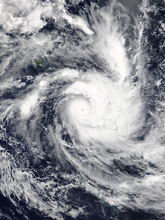
Madagascar is still reeling from storms Ana and Batsirai and has now been hit by yet another tropical cyclone – Emnati. The MapAction team will continue to provide situational data analysis, data visualisation and geospatial expertise. The crises will continue to be supported by a remote MapAction team in the UK who will gather, process and check data and create products.

View previous posts on our deployment to Madagascar

MapAction sends team to aid Madagascar Cyclone response

MapAction has mobilised a team to support the humanitarian response following Storm Batsirai, which hit Madagascar on Saturday evening. The team is due to leave on Tuesday.

Batsirai, a category three cyclone, swept away cars and houses, causing loss of life, flooding, landslides, destruction of infrastructure. It arrived with the country still reeling from Storm Ana which killed 55 people just weeks ago.

The scale of the situation is still emerging and MapAction’s team will help with that task. However media reports indicate that 250,000 people have been affected, more than 50,000 may be displaced and at least 10 people are known to have died so far. Many more may be affected as river levels are continuing to rise.

The United Nations Disaster Assessment and Coordination team (UNDAC) have requested MapAction’s situational data analysis, visualisation and geospatial expertise. MapAction will deploy a two person team to Kenya from where they will be able to enter Madagascar. We will then assess the situation and decide whether additional support might be necessary. 

MapAction has already started to produce maps and collate data and are making them available here: https://maps.mapaction.org/event/2022-mdg-001 

MapAction’s services are in ever more demand because of the increase in climate related events, be they food, infrastructure or conflict related. Although these events can’t be stopped, we can help mitigate the effects of these events and are actively working towards this goal. 

Read our latest news.

German Federal Foreign Office logo
We’re grateful to the German Federal Foreign Office for funding this work.

MapAction helps response to Cyclone Harold

While much of the world was focused on battling COVID-19 last week, a powerful tropical cyclone swept through the Solomon Islands, Vanuatu, Fiji, and Tonga, causing significant damage and loss of life.

With gusts over 170mph and rainfall of 250-450mm, Tropical Cyclone Harold was the worse storm to hit Vanuatu since Cyclone Pam in 2015, and, in some areas, damage has been significantly worse. Entire villages are reported to have been destroyed in the northern parts of the island chain.

In addition to the devastation caused by the storm, social distancing measures had to be temporarily lifted in some areas to enable people to gather in emergency shelters, and this may exacerbate the impacts of COVID-19 in the region. Furthermore, the crisis is largely remaining under the radar, given the ongoing pandemic, meaning little funding is being made available to assist the affected islands, despite tremendous need. What international aid there is has been hampered and delayed by the virus.

MapAction is already delivering support to the UN’s Office for the Coordination of Humanitarian Affairs (OCHA) in the Asia Pacific region (ROAP) to help the regional COVID-19 response. We have diverted some of this effort to respond to the emergency caused by Cyclone Harold, creating situation maps for Fiji and Tonga. These are helping humanitarian teams prioritise and coordinate aid. We will continue to provide assistance as needed.

Inside the Response to Cyclone Idai

MapAction volunteer Andreas Buchholz has just returned from Beira, Mozambique. He has put together the short video below, which gives a good sense of the scale and urgency of the international response to this major disaster.

While the floodwaters have begun to recede, the situation is still very serious in large parts of Mozambique and surrounding countries. Damage to homes and livelihoods is extensive and lack of access to clean water is causing outbreaks of diseases such as cholera.

MapAction has been working closely with the government of Mozambique, NGOs, the UN and Red Cross teams at the heart of the response and our help has been widely appreciated. The aerial assessment maps shown in the video have so far been printed over two thousand times and used to support search and rescue and the distribution of foodstuffs. The maps were created by the MapAction team in Mozambique with close collaboration with the International Federation of Red Cross and Red Crescent Societies, the UN Office for the Coordination of Humanitarian Affairs (UNOCHA) and Save the Children.

At the time of writing, MapAction personnel are continuing to work at the On-Site Operations Coordination Centre in Beira, Mozambique.

We are grateful to everyone that has donated to our Cyclone Idai appeal, to the UK’s Department for International Development (DFID) and to the Netherlands Ministry of Foreign Affairs for funding this life-saving work.