So far, the COVID-19 pandemic has reportedly caused 214 million illnesses and killed nearly four and a half million people worldwide (Google statistics). The impact on the poorest and most vulnerable people is immense, especially where populations are already facing several humanitarian crises.
MapAction has been working with GIMAC (the Global Information Management, Assessment & Analysis Cell) which was set up by several UN agencies and other international bodies to coordinate, collate, manage and analyse COVID-19 related information. The organisation also established a ‘field support’ mechanism, available to 25 countries currently implementing a Humanitarian Response Plan. On the ground, this meant providing technical support to a number of countries already facing significant ongoing humanitarian problems and keen to update their plans in light of Covid-19.
MapAction’s role was initially funded by the H2H network, and saw us assimilating the rapid data collection to provide GIS mapping and spatial analysis to support good decision-making. To do this, one of our team was seconded to the programme for two days a week.
As well as helping to gather initial data, we also used our GIS skills to provide mapping and other visualisations to countries on an open source basis.
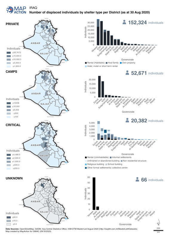
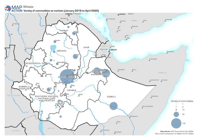
Our work on the programme is now coming to a close but throughout our time on the programme, we provided extensive geospatial analysis and data visualisation support. Overall we produced and provided around 60 maps and graphics on the impacts of the virus and any secondary shocks, alongside the ongoing humanitarian crises. These included baseline populations, food security levels, public security and educational accessibility.
Fawad Hussain, GIMAC Coordinator, OCHA, said, “MapAction has provided exceptional support to GIMAC and the country teams and it has been a pleasure to work with Matt and other MapAction colleagues.”

 DAKAR, 9 Feb – A severe food crisis is forecast to strike the Sahel region of West Africa later in 2012, potentially affecting 7 to 10 million people in eight countries (Senegal, Mauritania, Mali, Burkina Faso, Niger, Nigeria, Chad and Cameroon). Low rainfall, poor harvests and high food prices are making communities vulnerable to extreme malnutrition. The number of children dying from nutrition-related causes is already estimated at more than 490,000 per year.