Updates: MapAction sends humanitarian mappers to support UN Myanmar earthquake response. Funding urgently needed for MapAction’s response.

Last updated: Tuesday, April 8th, 13:00 UTC

Urgent appeal to continue MapAction’s mission in Myanmar

MapAction needs to raise £150k to continue our Myanmar mission, at the heart of the UN response. 

As the only Humanitarian Information Management agency located in Myanmar with the vanguard UN Disaster Assessment and Coordination Team, it is imperative that MapAction remains for as long as needed. We will soon run out of funds to do so. 

A DEC appeal has launched but ironically MapAction doesn’t have a big enough budget to access those funds. Despite being a critical UN partner with signed deployment agreements with UNDAC, UN OCHA, WHO, WFP, UNDSS etc, we mostly deploy volunteer experts, keeping costs low. 

Imagine trying to coordinate a major earthquake response, in a situation as complex as Myanmar. Now imagine doing it without any maps showing you what help is needed, where, and whether aid can get access to different locations, etc. If MapAction leaves, that may face the UN Assessment and Coordination Team. Please help us to stay.

More Details

  • A two person MapAction field team are currently in Myanmar, providing bespoke mapping and spatial analysis to the UN Disaster Assessment and Coordination Team (UNDAC).
  • The MapAction field team are backed up by the wider MapAction team of 70 GIS and Data specialists and the staff team, busily making and checking maps and data remotely.
  • MapAction is the only Information Management agency with UNDAC for Myanmar.
  • We have launched an appeal for £150k due to the complexities and costs of operating in Myanmar.

For Corporate/Organisational Donors – Please email : email fundraising@mapaction.org or idavis@mapaction.org and we will get back to you as fast as we can.

For individual donors please go to https://cafdonate.cafonline.org/5803#!/DonationDetails

#Ready2respond. Image: MapAction.
  • MapAction humanitarian data professionals en route to Myanmar at the request of the United Nations Disaster Assessment and Coordination (UNDAC) team
  • First MapAction maps and data sets published here. They include: a map of shake intensity by region, another of passable roads, and one more featuring administrative boundaries
  • The UN estimates that 18 million people are affected
  • MapAction will sit at the heart of the UN response system, providing situation maps and data support, to both UN and local disaster management agencies, to help them understand and prioritise multiple needs and hazards 
  • 7.7 Richter scale magnitude earthquake struck Myanmar, formerly known as Burma, on Friday March 28th with devastating consequences, affecting areas across the border in Thailand too
  • April 3rd: More than 3000 casualties so far, reports AP. Some agencies have estimated that the death toll may rise to more than 10,000 as a fuller picture of the devastation emerges in the coming days and weeks
  • MapAction’s emergency response work, as well as this response is funded by the German Federal Foreign Office’s Programme for Humanitarian Assistance but we will rapidly run out of remaining funding before we anticipate this emergency will be over. Please help us to carry on supporting the UN Disaster Assessment & Coordination team in Myanmar at www.mapaction.org/donate/

Tuesday, April 8th, 13:00 UTC: 9.1 million exposed to strongest tremors, says UN update

Monday, April 7th, 10:45 UTC: UN OCHA says 3000+ unconfirmed deaths, 5000+ injured and 17 million people affected

“Infrastructure damage includes 47 roads, 25 bridges, one destroyed bridge, and around 120,000 homes,” adds the statement, published last Friday, from the United Nations Office for Coordination of Humanitarian Affairs (OCHA).

Thursday, April 3rd, 09:30 UTC: Death toll rises above 3000, say Myanmar authorities

The death toll is now 3085, reports AP, based on official sources from within Myanmar.

Please support our Myanmar Appeal

The cost of scaling the initial response to such unexpected emergencies is a huge financial challenge for MapAction in what is already a difficult year for humanitarian funding. Please support our work to save lives in Myanmar if you can.

Thursday, April 3rd, 09:00 UTC: Statement from UN OCHA

Wednesday, April 2nd, 13:30 UTC: New MapAction map shows damaged and unpassable roads near epicentres

Roads are the conduits for emergency aid convoys, search and rescue operations and support teams. But an earthquake quickly redraws the geography of any place, meaning humanitarian leaders need regularly updated road maps to action the latest intelligence and implement effective decisions.

Wednesday, April 2nd, 13:20 UTC: Using MapAction maps? Please fill out our brief survey

Are you a regular, or perhaps even a new, user of MapAction’s maps and data repository? Please fill out this brief survey if so. We’d really value your feedback to improve the work we do. Thank you.


“Our goal is to support the United Nations Disaster Assessment Coordination (UNDAC) team and ensure that more lives can be saved through good use and analysis of data. This is MapAction’s 16th response to an earthquake so our teams know a thing or two about what to expect in the coming days and weeks. MapAction volunteers are specialists in converting information into easily understood maps, which are then used by emergency response leads to ensure assistance reaches those most in-need; when they need it most.”

MapAction Chief Executive Colin Rogers

Wednesday, April 2nd, 10:00 UTC: 19.9 million people in need of humanitarian assistance before the earthquake

A report published in December 2024, the Myanmar Humanitarian Needs and Response Plan 2025, estimated that 19.9 million people in Myanmar would need humanitarian assistance in 2025.

Wednesday, April 2nd, 07:35 UTC: ICRC images of destruction wreaked by earthquake in Myanmar

Please support our Myanmar Appeal

The cost of scaling the initial response to such unexpected emergencies is a huge financial challenge for MapAction in what is already a difficult year for humanitarian funding. Please support our work to save lives in Myanmar if you can.

Tuesday, April 1st, 15:00 UTC: Basic services, as well as food and water, still missing in affected areas in Myanmar

The UN’s Humanitarian Coordinator for Myanmar Marcoluigi Corsi has released a statement outlining the key needs of communities affected by the earthquake (up to 20 million people, according to some estimates).

“The immediate needs of the affected communities, as in any, I would say, earthquake, are becoming increasingly urgent: we have shelter, food, clean water, essential household items are all in short supply,” said Corsi in the statement. “Some of these supplies include, food, drinking water—there is a huge need for drinking water—shelter, temporary shelter to accommodate people,” added the UN’s Corsi. More here.

Tuesday, April 1st, 13:05 UTC: “In any emergency, data can be the key to saving lives”

“In any emergency, data can be the key to saving lives. That is why a MapAction team of humanitarian data professionals is en route to Myanmar, at the request of UNDAC, to support the humanitarian efforts: early search and rescue and damage assessment efforts in affected areas.”

Darren Dovey (MapAction), Head of Emergency Response

Tuesday, April 1st, 10:45 UTC: This is MapAction’s 16th earthquake response since we were founded in 2002

Tuesday, April 1st, 09:55 UTC: New MapAction map gives humanitarian leaders an overview of the country’s administrative and geographical boundaries

Tuesday, April 1st, 08:20 UTC: MapAction map shows passable roads after the earthquake

Monday, March 31st, 17:00 UTC: Why is MapAction sending geospatial and humanitarian information management specialists to Myanmar?

“Our goal is to support the United Nations Disaster Assessment Coordination (UNDAC) team and ensure that more lives can be saved through good use and analysis of data. This is MapAction’s 16th response to an earthquake so our teams know a thing or two about what to expect in the coming days and weeks. MapAction volunteers are specialists in converting information into easily understood maps, which are then used by emergency response leads to ensure assistance reaches those most in-need; when they need it most.”

MapAction Chief Executive Colin Rogers
MapAction CEO Colin Rogers

Monday, March 31st, 16:40 UTC: MapAction map of shake intensity by state/regions

Please support our Myanmar Appeal

The cost of scaling the initial response to such unexpected emergencies is a huge financial challenge for MapAction in what is already a difficult year for humanitarian funding. Please support our work to save lives in Myanmar if you can.

This is MapAction’s 16th earthquake response. Another (fairly) recent earthquake response we were involved in was in Turkiye, in February 2023.

READ MORE: MapAction team in Turkiye working on disaster landscape maps and supporting earthquake response at UNDAC’s request

Video: What is MapAction?

Monday, March 31st, 13:55 UTC: A map can show “scope and scale” of an earthquake

How can a map, featuring data points such as shake intensity or population density, influence a humanitarian leader? This from MapAction’s Example Product Catalogue page on earthquakes (this is MapAction’s 16th earthquake response):

The map will provide context to the potential scope and scale of the earthquake. It shows them the location of the epicentre (and aftershocks) and the intensity in different areas. When this is shown with population data it will also give an indication of potentially where the most affected people will be. It will inform them of where potential search and rescue activity might be required.

MapAction Example Product Catalogue: Earthquakes

Monday, March 31st, 11:35 UTC. UNICEF: one million children affected.

According to official figures, more than 1,600 people have been killed and over 3,400 injured—many of them children, states a UNICEF update from the UN’s ReliefWeb portal. “This earthquake is another brutal blow to children in Myanmar—many of whom were already living through conflict, displacement, and deprivation,” says UNICEF Executive Director Catherine Russell. The update states a million children are affected by the earthquake.

Friday, March 28th, 15:20 UTC: MapAction sends team to Myanmar to support earthquake response

MapAction’s expert team have already started working around the clock, and will be doing so for many weeks, transforming fast emerging data into critical and life saving information and analysis, that can be immediately understood, enabling responders to navigate the chaos and save as many lives as possible. 

Can you help?

MapAction will do everything we can, but we need your help. The aid cuts that you may have heard about are hitting hard, meaning that we believe we may lack enough funds to see through the entire Myanmar response.

MapAction doesn’t receive funding from the big public appeals you might see, and we move too fast for them in any case. Our teams are usually in situ and working, many days before such appeals are even launched. We rely on the generosity of supporters, and on funds provided in advance or immediately after emergencies, ready for the next one. We need to fund things like flights, accommodation, technical support, insurance, technical kit and much more. 

Any donation that you can make now will mean we can remain providing support for as long as we are needed, and continue to be responsive, agile and ready for action, for this emergency and those to come. Please, stand with us and donate via www.mapaction.org/donate/

MapAction’s life-saving know-how.

We know we are asking for money at a difficult time but it is only because we know the critical, essential value of MapAction’s work can lead to far less deaths. This will be MapAction’s 16th Earthquake Disaster Response – we bring vital know-how. We know exactly what decisions must be made, when, and which maps and data will support them. In the early stages, our maps guide aid workers through search and rescue operations, pinpoint areas and populations in greatest need and ensure vital supplies reach those who are suffering most. 

Our volunteers give up their time to train intensively, all year round to provide lifesaving support in situations such as this. Please help to make sure they can meet all of the needs of the Myanmar/Thailand response, and be ready to do so again, the next time the UN or another partner calls.

Give here

To give a donation please go to www.mapaction.org/donate/  To discuss corporate or larger support please email idavis@mapaction.org.uk

Read about a previous MapAction earthquake response here – https://mapaction.org/live-mapaction-team-flies-at-undacs-request-to-support-turkiye-syria-earthquake-response/

Automated Data Pipeline: Towards data quality standards

Automating a country’s basic data to gain time in a disaster involves many complex variables. Since 2022, MapAction, the United Nations Office for the Coordination of Humanitarian Affairs (UN OCHA) and the University of Georgia, Information Technology Outreach Services (ITOS) have been working on strengthening data quality for what are referred to as Common Operational Datasets (COD): ‘best available’ shared datasets that ensure consistency and simplify the discovery and exchange of key data among humanitarian organisations. In this article, we briefly present the methodology.

Common Operational Datasets, or CODs, are authoritative reference datasets needed to support operations and decision-making for all actors in a humanitarian response. CODs are ‘best available’ datasets that ensure consistency and simplify the discovery and exchange of key data. The data is typically geo-spatially linked using a coordinate system and has unique geographic identification codes. These datasets are often derived from data collected by local authorities and international partners to ensure quality, but most vitally, local ownership. CODs can be collected on administrative boundaries, population and more.

The three main datasets available within the CODs for most countries are COD-AB (Administrative Boundaries), COD-PS (Population Statistics) and COD-HP (Humanitarian Profile). Country-specific CODs, such as the road network and health facilities may also be available. They can be easily found on HDX (Humanitarian Data Exchange) on the COD page or through the service API managed by ITOS.

Moreover, OCHA routinely evaluates the quality and availability of Common Operational Databases. The results of this analysis can be found on the COD Portal. The Portal documents: 

  1. The quality of administrative boundary (COD-AB) layers and population statistics (COD-PS) tables, and;
  2. Their availability on HDX and for COD-AB as an ITOS geoservices.  The portal is generally refreshed after any COD-AB or COD-PS is added or updated. 

Keeping humanitarian data fresh

This project focused on the COD-AB. As shown in the picture below, each available country has different level administrative boundaries together with metadata and p-codes.

READ ALSO: Accelerating humanitarian response: Inside MapAction’s Automated Data Pipeline

The proposed methodology evaluates both the geospatial features as well as the metadata.

The objective of this project was to create a quantitative assessment mechanism that enables the prioritization of work to update or enhance existing COD-AB datasets. The output is a quality index for each COD-AB data set based on tests for features (geographical, metadata, etc), targeted at both OCHA and ITOS teams and available to the public as an open-source tool.

The main deliverable of this project is the COD-AB Data Quality dashboard. Through this webpage hosted on FieldMaps — Humanitarian Maps & Data , the quality multi-index per country can be visualized through a dedicated dashboard, downloaded as a spreadsheet or as individual country pdf reports detailing the methodology. Moreover, the Python code is publicly available on a GitHub code repository for advanced users.

Methodology

The methodology for computing each country COD-AB quality index is based on a multi-index approach where separate scores are computed for each category, covering both geospatial features as well as metadata such as languages and p-codes.

The overall score for a given country is a value between 0% and 100% and is computed as the average value of 10 different categories. For each category, the score is computed as the proportion of layers matching a set of quality criteria. Within the dashboard, users can select which categories they wish to use when computing the overall score.

Scores computed for each country as well as a detailed country report can be found on the publicly available dashboard webpage hosted on fieldmaps.

Methodology description

The complete list of indicators used within each category can be found on the dedicated country reports on the project dashboard. Below is a list of descriptions for each category used in the overall score calculation.

Valid Geometry: Valid geometry is defined by having no empty geometries, only containing polygons (no points or lines), not containing self-intersecting rings, using WGS84 CRS (EPSG:4326), and a valid bounding box.

Valid Topology: Valid topology is defined as having no triangle polygons, sliver gaps or overlaps within a layer, with each polygon being fully contained within their parent.

Equal Area: Layers which all share the same area. Layers not sharing the same area may have empty areas representing water bodies whereas other layers have them filled out.

Sq. km: Layers which have an area attribute in square kilometers and value matches area calculated above using NASA EASE-Grid 2.0.

P-Codes: Layers which have all required P-Code columns (ADM2_PCODE), with no empty cells, only alphanumeric characters, starting with a valid ISO-2 code, no duplicate codes, all codes within a column having the same length, and hierarchical nesting codes.

Names: Layers which have all required name columns (ADM2_EN), with no empty cells, no duplicate rows, no double / leading / trailing spaces, no columns all uppercase / lowercase, no cells lacking alphabetic characters, and all characters matching the language code.

Languages: Layers which have at least 1 language column detected, all language codes used are valid, a romanized language is featured first, and layers don’t have more languages than their parents.

Date: Layers which have a valid date value for their source.

Valid On: Layers which have been validated on within the last 12 months.

Other: Layers which have no fields other than expected values.

READ ALSO: MapAction Anticipatory Action Sustainability Methodology

Conclusion and way forward

The main target audience for this project are both OCHA FISS, OCHA HDX and ITOS teams that are directly involved in evaluating and improving the quality of the CODs. This project was tailored to their needs and it’s hoped to streamline the initial quality process. By making both the results and methodology publicly available online, we hope other CODs stakeholders will integrate quality analysis in their decision making.

This project has also been a great opportunity for collaboration between the MapAction team and Maxym Malynowsky, humanitarian data expert responsible for, among others, fieldmaps.io. Maxym joined the project together with MapAction volunteers and played an essential role on designing, implementing and promoting this work. Within his new role as Data Engineer Advisor at the OCHA Centre for Humanitarian Data, Maxym will be able to link this work with the quality needs of HDX datasets.

MapAction will continue to be involved on the COD data quality topic by both taking part in the sector discussions with key stakeholders and also as a direct user in the context of emergency responses.

The dashboard will continue to be hosted by FieldMaps — Humanitarian Maps & Data and Maxym Malynowsky will be the main point of contact.

This work is funded by USAID’s Bureau for Humanitarian Assistance (BHA).

Find out more about MapAction’s data work in another field, Anticipatory Action, in the video below.

MapAction Data Science Lab: the story so far

Since its inception MapAction has worked on leveraging technical expertise and geospatial technologies to transform humanitarian decision-making. In 2022, the ‘Data Science Lab’ became an even more integral part of MapAction’s work, adding new staff, resources and projects. 

By Daniel Soares, Head of Data Science, MapAction

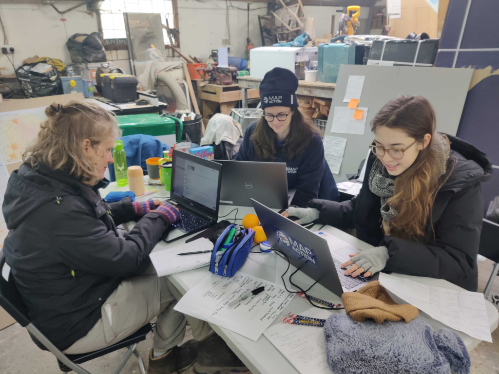
The first tentative steps to establish a data science unit at MapAction began in 2020 with one staff data scientist and another volunteer working in partnership with OCHA Centre for Humanitarian Data. The team continued to grow and on a summer night in 2022, the Data Science Lab was officially born. Eighteen months later the team has grown: we now have two staff members and six data science volunteers. Four more are set to join in 2024. This is, of course, without counting our many GIS volunteers with advanced data skills working as data scientists or similar roles in their prestigious day jobs.

READ MORE: A year of collaboration with the Centre for Humanitarian Data

Carola Martens, data science volunteer, taking part in an earthquake simulation to test her deployment capabilities together with geospatial volunteers Fiona Hardie and Claudia Offner. Photo: Daniel Soares

Data projects supporting disaster response 

“At the Global Facility for Disaster Reduction and Recovery (World Bank), I specialise in developing tools for assessing the impacts of natural disasters in various settings. Having joined MapAction I’ve found that it complements this work as it offers me the opportunity to apply my expertise in a different context, where I can contribute both to long-term planning and to direct emergency response.”

Nadia Leonova, MapAction data science volunteer

In the last 18 months our volunteers have done some impressive work, not only on tool development, but on missions leading workshops, as well as supporting our GIS team with disaster response. Below are some examples of tools and projects we’ve been working on.

Rapid flood mapping

The goal of our rapid flood mapping from satellite imagery is to create a tool that is able to estimate flood extents during emergencies using radar satellite imagery. The tool was created by two of our data science volunteers, with Cate Seale developing a Python package that contains all the necessary methods whilst Piet Gerrits worked on equipping the tool with a simple graphical interface. The approach is based on a UN SPIDER tutorial, built using Google Earth Engine. The entire code is naturally open-source and available on GitHUB (GitHub – mapaction/flood-mapping-tool).

Former volunteer and current MapAction Head of Data Science Daniel Soares (left) during the MapAction response to the 2022 Kinshasa floods (DRC) together with an UNDAC team member and a local expert. Photo: MapAction.

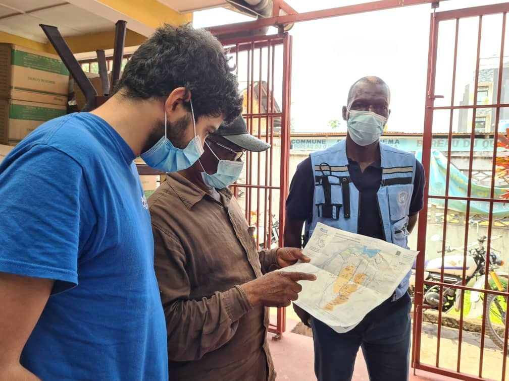
READ MORE: MapAction team deploys to Democratic Republic of Congo (DRC) to support UN response to floods 

In 2021, MapAction engaged in a collaboration with HeiGIT (Heidelberg Institute for Geoinformation Technology): the final goal of this work is to produce tools and workflows that can constitute a resource for MapAction’s deployed or remote team members during emergency response. Our first joint project focused on assessing OpenStreetMap data quality. We’re now working to integrate these quality checks into our internal data pipeline.

READ ALSO: MapAction and HeiGIT partner to further geoinformation innovation
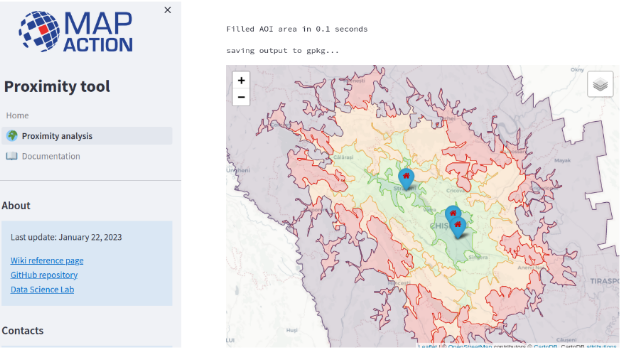
Proximity Tool

As part of the same collaboration with HeiGIT, we’re currently developing a Proximity Tool in order to automate road network analysis and identify remote communities and those potentially cut off during an emergency. This tool can also be used for health accessibility analysis (assessing populations not covered by health facilities within a given road distance).

First prototype of the MapAction Proximity Tool developed in collaboration with HeiGIT’s open route service.

Anticipatory action

MapAction substantially increased its anticipatory action focus in 2023. Our new anticipatory action programme kicked-off in July with GFFO funding new work on several projects geared at enhancing geospatial information management for anticipatory action decision makers. This programme will mainly focus on three areas: enabling adoption by partners through stakeholder landscaping and information management projects (ongoing work with the Philippine Disaster Resilience Foundation); implementation of subnational risk models and working around building sustainability and localisation with partners.

READ ALSO: Updates: The Anticipation Hub, The 11th Global Dialogue Platform on Anticipatory Action

The Data Science Lab is actively mainstreaming anticipatory action into its pipeline for the future. We have already started working on building an INFORM Subnational Risk Index for the Kingdom of Eswatini while scoping support for other countries. Our target is to work on four new INFORM subnational models, while updating eight more, over the next two years. We are also currently scoping and planning new projects in partnership with the UN’s Centre for Humanitarian Data around data solutions for anticipatory action. Stay tuned for more details in 2024.

Data science member Piet Gerrits and MapAction Data Visualiser Rob Baker attend an INFORM Subnational Risk training in Italy together with MapAction geospatial volunteer Leon Baruah in September 2023 ( all MapAction members are in blue t-shirts).

Want to be part of the team?

Our 2023 volunteer recruitment process is now closed but a new one will open in 2024 with opportunities for data scientists, data visualisers, data engineers, software developers and geospatial specialists.

Join our MapAction Humanitarian Data Volunteers group on LinkedIn to receive the latest updates re: recruitment or follow MapAction on Twitter, LinkedIn or Instagram.

READ MORE: MapAction looking for volunteers to unlock information management barriers in humanitarian sector

MapAction’s work in geospatial is funded by USAID’s Bureau for Humanitarian Assistance, the German Federal Foreign Office (GFFO), UNICEF, Calleva Foundation and other foundations, private individuals and companies. Learn more here.