MapAction is supporting national and local disaster management authorities to reduce and address the multiple risks faced, provide better early warning systems and facilitate risk-informed development. We kickstarted our work in Eswatini.
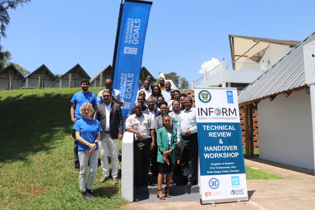
MapAction team members Daniel Soares and Anne-Marie Frankland, left, in blue t-shirts, together with representatives from UNDP, NDMA and other Eswatini agencies and ministries during the INFORM handover workshop in December 2023.
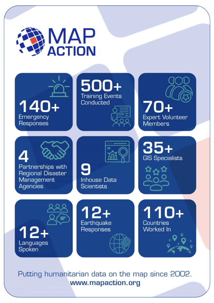
For nearly 20 years, in 140+ emergencies, MapAction has supported countries in mitigating disasters. Since July 2023, in partnership with the European Commission’s INFORM Risk Index, MapAction is working to support national and subnational disaster managers to update or rebuild their disaster forecasts, mitigating tools and risk atlases.
INFORM subnational risk models are an important source of information for anticipatory action, development and preparedness projects. Making sure that the models are high quality, with the best available data – and readily maintained, is essential.
In October 2023, MapAction began working with disaster authorities and international partners to build a risk and disaster model for Eswatini, a country in southern Africa with a population of just over one million. Building the risk model involves four technical processes: data collection, data processing, data calibration and data validation. All contribute to data quality control and the ‘authority’ of the model.
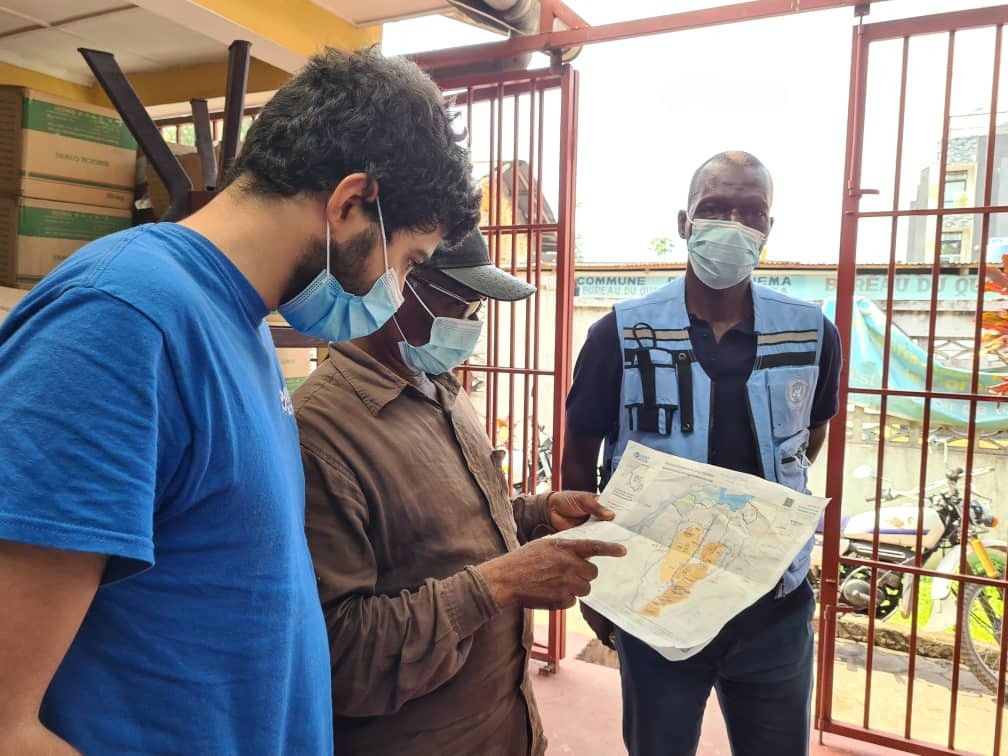
MapAction’s Head of Data Science Daniel Soares meets disaster management authorities and stakeholders in Eswatini, southern Africa. Photos: MapAction.
“We are really pleased to currently work with four regional disaster management agencies across Asia and Africa, as well as working with many national disaster management authorities,” says MapAction’s CEO Colin Rogers. “Working with regional and national structures is core to our approach in strengthening global humanitarian geospatial capability,” adds Rogers.
Fire extinguishers put out fires: fire alarms help prevent them. This risk assessment work is in partnership with various national and international partners, including: the Eswatini National Disaster Management Agency (NDMA), UNDP and German technical development agency GIZ and will serve as a basis for the future SADC regional model also developed by UNDP, GIZ and SADC country members.
“Address multiple risks” “UNDP Eswatini is committed to working… to reduce and address multiple risks we are facing, provide better early warning systems and facilitate risk-informed development to progress towards aspirations and goals set in the National Development Plan,” said UNDP’s Eswatini Deputy Resident Representative Nessie Golakai, outlining the UN agency’s goals on anticipatory action, in December 2023.
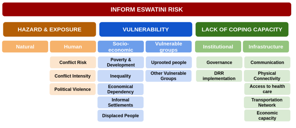
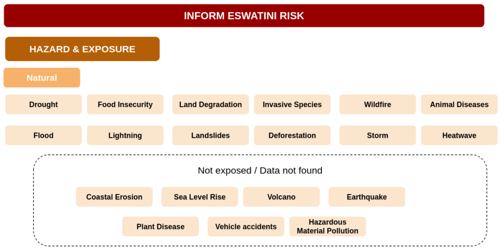
Eswatini: risk overview
An INFORM Subnational risk index shows a detailed picture of risk and its components within a single region or country. It covers not only hazards exposure (e.g. earthquakes, floods and conflicts) but also a country’s vulnerabilities, such as diseases prevalence and poverty, as well as its coping capacity. Of particular interest for Eswatini are droughts and associated food insecurity issues. In 2023, 238,000 in Eswatini faced “acute food insecurity,” according to an IPC study reported on ReliefWeb. Eswatini also has the highest HIV prevalence in the world, according to data from the World Health Organisation (WHO).
For the first phase of strengthening Eswatini’s risk model, a consultation workshop took place in August 2023 bringing together national partners, SADC representatives, GIZ and UNDP. During the workshop, the model framework was defined, covering which indicators are most relevant for Eswatini and other SADC countries. A total of 87 indicators from 49 data sources were identified, including data from public international agencies such as the WHO, the Food and Agriculture Organisation of the United Nations (FAO) and the World Bank, as well as national ministries, agencies and databases.
Then comes the data processing. Data comes in different formats such as spreadsheets, pdf reports and geospatial vectors and rasters. The processing can be as easy as finding a given value for the adult literacy per region on a report or as complicated as manipulating several geospatial rasters and administrative boundaries to compute exposed population to flooding per sub-region.
Making data comprehensible
The data then needs to be calibrated. Values have different ranges and units, such as number of casualties, corruption index, immunisation rate or health facilities density. To be able to aggregate these values on a single index, a normalisation is needed, such as dividing all values by the maximum within a country or region. Once indicators are expressed in a common format (a value between 0 and 10) we can aggregate them to have one index per dimension (Hazards, Vulnerability and Capacity) and finally a single index per subnational zone.
These three steps all produce margins of error; in the final phase the data is reviewed and validated. In this phase, indicators are verified and where necessary, corrected. Partners from Eswatini made vital contributions to validate the overall results and methodologies and suggest improvements.
Handover and sustainability
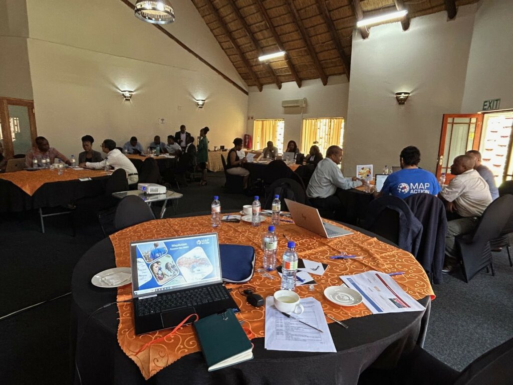
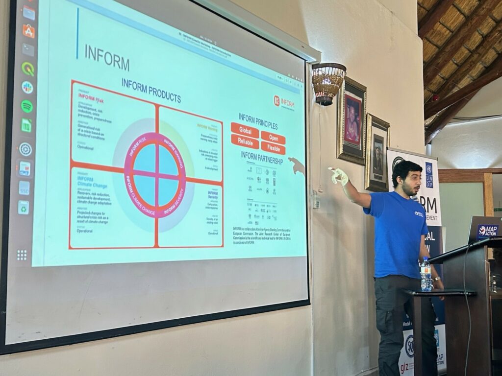
The work was presented to partners at a two-day handover workshop in Eswatini in December 2023 by MapAction’s Head of Data Science Daniel Soares, Senior Meal Advisor Samuel Asimi and Volunteer Anne-Marie Frankland. This handover workshop was intended for NDMA staff to take ownership of the model, while also validating it to identify improvements. The two-day event also incorporated professional development components pegged to the INFORM methodology with a practical focus on data collection, processing and calibration.
On a practical note, three ways also emerged from the event as to how the model would be used going forward.
To support decision making on disaster preparedness, early action, disaster response and recovery.
To determine the level of exposure and vulnerability of localities for improved policy recommendation and more effective DRR measures
To coordinate data collection, storage and sharing in order to strengthen reporting and decision making based on scientific evidence. The data will be updated according to the agency’s needs, although MapAction’s recommendation is a complete update every 24 to 36 months.
MapAction’s Head of Data Science Daniel Soares presenting with local partners in Eswatini.
MapAction’s work in Eswatini is part of a larger project supported by the German Federal Foreign Office to strengthen global anticipatory action frameworks at local level. MapAction will work with several countries on new subnational models for disaster preparedness in the course of the next 18 months.
Work has already begun on developing a new subnational risk model for Saint Kitts and Nevis. We are also currently scoping new collaborations for early 2024 in Madagascar, Vanuatu, Fiji and Lebanon.
Sustainability
A key part of the work MapAction does is to ensure the sustainability of various interventions we carry out across the globe. We do this through identifying and unblocking barriers in a collaborative way with our partners. The aim of this is to encourage the building of sustainable systems to outlive MapAction’s support to these partners who may be state or non-state actors.
In addition to the above, within MapAction’s Anticipatory Action programme, we seek to ensure longevity and sustainability by establishing effective evaluation frameworks and sharing lessons learned with the wider community.
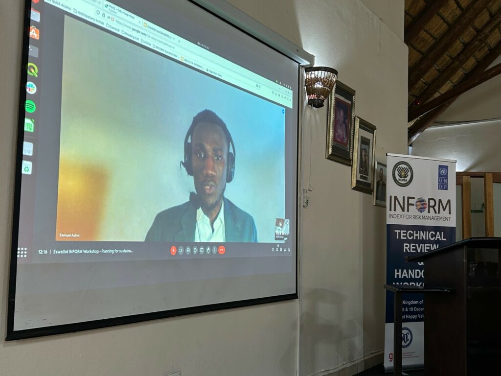
During the 2023 December Workshop, one session on Sustainability was hosted by Samuel Asimi, who highlighted the sustainability components for the INFORM Eswatini Risk model.
He noted that the handover workshop was the first of three components of the sustainability plan. The other two which will follow are the planned sustainability landscape mapping and the co-creation of an action plan. This initiative will be led by the NDMA and supported by MapAction.
Since its inception MapAction has worked on leveraging technical expertise and geospatial technologies to transform humanitarian decision-making. In 2022, the ‘Data Science Lab’ became an even more integral part of MapAction’s work, adding new staff, resources and projects.
By Daniel Soares, Head of Data Science, MapAction
The first tentative steps to establish a data science unit at MapAction began in 2020 with one staff data scientist and another volunteer working in partnership with OCHA Centre for Humanitarian Data. The team continued to grow and on a summer night in 2022, the Data Science Lab was officially born. Eighteen months later the team has grown: we now have two staff members and six data science volunteers. Four more are set to join in 2024. This is, of course, without counting our many GIS volunteers with advanced data skills working as data scientists or similar roles in their prestigious day jobs.
Carola Martens, data science volunteer, taking part in an earthquake simulation to test her deployment capabilities together with geospatial volunteersFiona Hardie and Claudia Offner. Photo: Daniel Soares
Data projects supporting disaster response
“At the Global Facility for Disaster Reduction and Recovery (World Bank), I specialise in developing tools for assessing the impacts of natural disasters in various settings. Having joined MapAction I’ve found that it complements this work as it offers me the opportunity to apply my expertise in a different context, where I can contribute both to long-term planning and to direct emergency response.”
Nadia Leonova, MapAction data science volunteer
In the last 18 months our volunteers have done some impressive work, not only on tool development, but on missions leading workshops, as well as supporting our GIS team with disaster response. Below are some examples of tools and projects we’ve been working on.
Rapid flood mapping
The goal of our rapid flood mapping from satellite imagery is to create a tool that is able to estimate flood extents during emergencies using radar satellite imagery. The tool was created by two of our data science volunteers, with Cate Seale developing a Python package that contains all the necessary methods whilst Piet Gerrits worked on equipping the tool with a simple graphical interface. The approach is based on a UN SPIDER tutorial, built using Google Earth Engine. The entire code is naturally open-source and available on GitHUB (GitHub – mapaction/flood-mapping-tool).
Former volunteer and current MapAction Head of Data Science Daniel Soares (left) during the MapAction response to the 2022 Kinshasa floods (DRC) together with an UNDAC team member and a local expert. Photo: MapAction.
In 2021, MapAction engaged in a collaboration with HeiGIT (Heidelberg Institute for Geoinformation Technology): the final goal of this work is to produce tools and workflows that can constitute a resource for MapAction’s deployed or remote team members during emergency response. Our first joint project focused on assessing OpenStreetMap data quality. We’re now working to integrate these quality checks into our internal data pipeline.
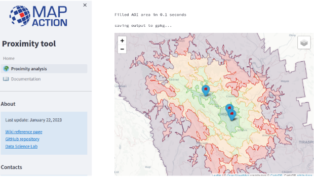
As part of the same collaboration with HeiGIT, we’re currently developing a Proximity Tool in order to automate road network analysis and identify remote communities and those potentially cut off during an emergency. This tool can also be used for health accessibility analysis (assessing populations not covered by health facilities within a given road distance).
First prototype of the MapAction Proximity Tool developed in collaboration with HeiGIT’s open route service.
Anticipatory action
MapAction substantially increased its anticipatory action focus in 2023. Our new anticipatory action programme kicked-off in July with GFFO funding new work on several projects geared at enhancing geospatial information management for anticipatory action decision makers. This programme will mainly focus on three areas: enabling adoption by partners through stakeholder landscaping and information management projects (ongoing work with the Philippine Disaster Resilience Foundation); implementation of subnational risk models and working around building sustainability and localisation with partners.
The Data Science Lab is actively mainstreaming anticipatory action into its pipeline for the future. We have already started working on building an INFORM Subnational Risk Index for the Kingdom of Eswatini while scoping support for other countries. Our target is to work on four new INFORM subnational models, while updating eight more, over the next two years. We are also currently scoping and planning new projects in partnership with the UN’s Centre for Humanitarian Data around data solutions for anticipatory action. Stay tuned for more details in 2024.
Data science member Piet Gerrits and MapAction Data Visualiser Rob Baker attend an INFORM Subnational Risk training in Italy together with MapAction geospatial volunteer Leon Baruah in September 2023 ( all MapAction members are in blue t-shirts).
Want to be part of the team?
Our 2023 volunteer recruitment process is now closed but a new one will open in 2024 with opportunities for data scientists, data visualisers, data engineers, software developers and geospatial specialists.
Welcome to the first post in a new blog series on anticipatory action. The series will explore MapAction’s work to strengthen readiness and preparedness worldwide. We’ll kick off with a few facts and definitions, as well as a review of some of the key sessions and agenda points from the The Anticipation Hub: The 11th Global Dialogue Platform on Anticipatory Action, which is currently underway in Germany’s capital Berlin. This blog is part of an anticipatory action programme by MapAction kindly supported by the German Federal Foreign Office and the Insurance Development Forum.
What does this blog cover?
Summaries, notes, images, cartoons and observations from the The 11th Global Dialogue Platform on Anticipatory Action
Anticipatory action: definition, components, facts and overview
Examples of MapAction’s work in anticipatory action
The 11th Global Dialogue Platform on Anticipatory Action is currently live from Berlin! Register here to watch it. Listen in as disaster management experts from across the world discuss the latest vanguard thinking on how to mitigate climate change and weather-related hazards.
Guten Morgen. Here are some highlights to look forward to today, the final day of the The 11th Global Dialogue Platform on Anticipatory Action taking place in Berlin.
We are up and running on our final day of #GlobalDP – come and join us for our opening plenary
Final day of the 11th #GlobalDP | In one of the sessions, ACAPS specialists Diogo Lemos, Francesca Giovinazzo, and Nic Parham will explore how joint analysis sets the stage for effective preparedness measures and more fit-for-purpose and impactful anticipatory action.
The Berlin Festival of Lights, which sees important landmarks in the German capital illuminated in technicolour, is also underway in Germany’s capital.
October 11th. 15:05 UTC
Heading into the final Day Two sessions now. With that, we’ll be wrapping up our Anticipation Hub blog today. We will add brief summaries and the odd pic tomorrow.
We’ll leave you with the excellent selection of anticipatory action cartoons to wind down with. Bis Morgen!
October 11th. 13:25 UTC
The Data Guardian Game for anticipatory action: a workshop on availability of data in anticipatory action.
“A useful tool to help participants grasp the significance of data in the decision-making process.”
Luke Caley from IFRC outlines the organisation’s database “with 100 years of disasters to learn from”.
“Global data needs to be verified on the ground”. Now the game begins.
Participants are divided into four groups, assuming the roles of government decision-makers. Each group is tasked with investing in various governmental agencies to enhance their data collection and analysis capabilities.
In the second stage of the game, a flood scenario is introduced, prompting participants to gather information exclusively from the agencies in which they had initially invested; they are only permitted to access data and information from these specific agencies. Armed with this information, the groups then proceeded to make crucial judgments regarding the activation of an early action protocol.
MapAction and anticipatory action
MapAction’s work in anticipatory action is kindly supported by the German Federal Foreign Office and the Insurance Development Forum, as well as other individual and institutional donors. Our work in anticipatory action takes on different shapes and forms from territory to territory and is correlated to disaster risk reduction initiatives worldwide. The list below is non-exhaustive and is designed to give a brief overview of MapAction anticipatory humanitarian action work.
In Kenya we work with Oxfam and the Arid and Semi-Arid Land (ASAL) Humanitarian Network to forecast and map the potential impacts of drought on northern counties. “The Arid and Semi-Arid Lands (ASAL), in Kenya cover close to 80% of the land and are home to approximately 36% of the country’s population, 70% of the national livestock and 90% of the wildlife,” states ASAL’s website. “The residents of the ASALs earn their living through a mix of pastoralism and agriculture. However, pastoralism is the main source of livelihood contributing to 13% to the GDP of Kenya and further plays a vital role in both the economic and socio-cultural development of the resident communities.” Recent droughts over the last five years have left CSOs and the communities they work with in the northern Kenyan counties of Isiolo, Kwale, Marsabit, Nyeri, Kitui and Taita Taveta more vulnerable. MapAction’s aim with this work is to increase the visibility of the work CSOs are doing in humanitarian action and to help them leverage their forecasts to release early funding and create resilience against future hazards for local residents. MapAction’s support focused on mapping at county and even ward-level, a more localised administrative unit, ensuring CSOs can integrate GIS and IM into their disaster management tools .
Start Network is another key partner for MapAction. In the last few months alone, MapAction volunteers have delivered resilience-building seminars and events for local disaster managers in Nepal, Bangladesh, the Philippines, Senegal and Madagascar.
Some of the most important work MapAction does under the umbrella of anticipatory action is through the INFORM network, the “multi-stakeholder forum for developing shared, quantitative analysis relevant to humanitarian crises and disasters.” MapAction works with several national and subnational disaster management agencies worldwide through this framework, including ongoing projects to build or upgrade national disaster models in Eswatini and Niger.
October 11th. 13:10 UTC/15:10 CEST:MapAction Chair of Trustees Nick Moody is talking next on a panel in his role as coordinator of the Global Risk Modelling Alliance (GRMA). Nick shared his thoughts briefly on MapAction’s role through the prism of anticipatory action when we caught up with him in Berlin.
“There is evidence here of real momentum towards managing risk, instead of constantly being wrong-footed by extreme events when they happen. Baseline risk assessment – necessary for pre-arranging crisis finance – is constantly improving, and forecasting is good enough to make operational decisions ahead of the impact of an imminent flood, cyclone or drought. MapAction is helping to drive this momentum, particularly in working side by side with local CSOs and NGOs in developing these critical new capabilities.”
Chair of Trustees at MapAction Nick Moody
The Global Shield and its relevance to anticipatory action
The Global Shield against Climate Risk is a new initiative to avert, minimize and address climate-related losses and damages by scaling up climate and disaster-risk financing instruments, coupled with social protection mechanisms and early warning systems. The initiative was launched at last year’s UN Climate Conference, building on a joint effort by the G7 and the Vulnerable 20 Group (V20).
This workshop will introduce the aims and structure of the Global Shield, including how the Global Shield Solutions Platform and the Global Shield Financing Facility can both provide support for climate- and disaster-risk financing instruments, including anticipatory action approaches; it will also explore the role of the anticipatory action community.
Register for or watch the workshop here. Starts at: 13.15 UTC/15:15 CEST.
Moderators
Jonathan Auer, Junior Advisor, Global Shield Secretariat
Lea Sarah Kulick, Advisor, Secretariat of the Global Shield against Climate Risks
Speaker
Lorraine Njue, Head of Actuarial, ARC Ltd
Nick Moody, Cooordinator, Global Risk Modelling Alliance (GRMA)
Kaavya Ashok Krishna, Senior Financial Sector Specialist, World Bank / Global Shield Financing Facility
Annette Detken , Head of the Global Shield Solution Platform , Frankfurt School of Finance & Management
Kip Koskei , Director of Strategic Partnerships , Insurance Development Forum
Emily Montier, Consultant, World Bank
New countries can apply for support from the Global Shield at CoP28.
11.11.11 A team of 11 strong Nepali delegation at the 11th #GDP2023 ready for the 2nd day of the dialogue on 11th Oct.
Break in plenary session at the #GlobalDP. Back this afternoon. Here are some other things to think about during the break. We’ll be back to wrap things up this afternoon.
Volunteer with MapAction to work on anticipatory action projects!
A lot of the work MapAction does in anticipatory action (with the Start Network and INFORM) involves our volunteer cohort of 70+ GIS and IM specialists. We are currently recruiting for six new exciting volunteer positions. Read on here to find out more about volunteering with MapAction.
Find out more about the volunteer community of practice at MapAction here.
2. Check out this UN video on role of data in AI in building resilience
INTERESTING RESOURCE (from the UN): Reimagining Tomorrow: Breakthrough in Data and AI for a More Resilient World
“Step into the future with the UN-hosted Complex Risk Analytics Fund, the Early Warnings for All initiative and Gzero Media at the 78th United Nations (UN) General Assembly. As we navigate an era of multifaceted global crises – amplified by climate change – recent breakthroughs in artificial intelligence (AI), technologies, and data ecosystems create transformative opportunities to tackle these challenges. Together with global leaders and change-makers, we envisage a world where global partners unlock the potential of data, analytics, and AI to better anticipate crises and pave the way for a more sustainable and resilient future.”
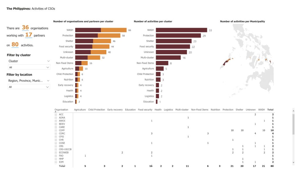
An ongoing project in the Philippines with the Philippines Disaster Resilience Foundation (PDRF) on disaster landscape mapping.
In the Session 2 panel, titled, A roadmap to institutionalisation: anticipatory action milestones towards shared resilience, representatives from disaster management agencies in the Philippines, Nepal and Bangladesh. All three governments are mainstreaming anticipatory action strategies into their disaster risk reduction policies.
MapAction works closely with all three countries to create disaster resilience through the Start Network. In the last few months, MapAction volunteers have led disaster-resilience seminars focused on mapping the potential impacts of future hazards in all three countries. MapAction will be presenting the results from partnerships in Nepal at NetHope this month.
Really interesting interventions from WFP Mozambique on how the national disaster management agency, the national meteorological agency and agencies mandated to support and manage agriculture have been coordinating their anticipatory action policies. A representative from Burkinabe Red Cross follows up asking how governments can be convinced to institutionalise anticipatory action and early action policies.
October 11th, 08:10 UTC
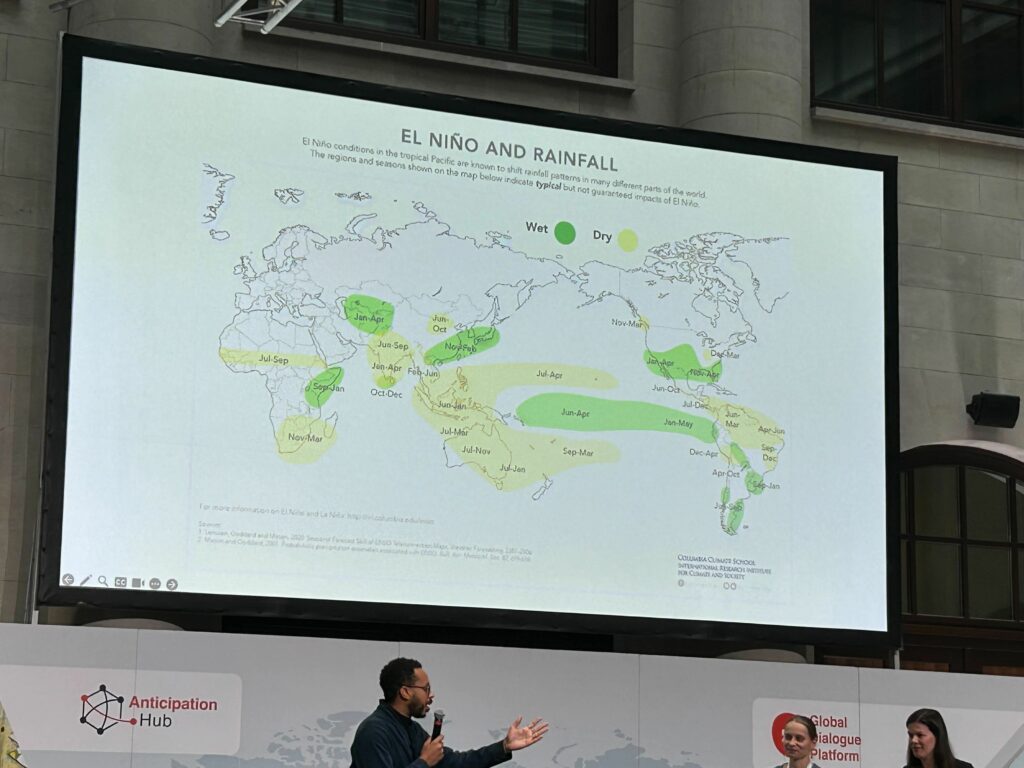
Welcome to Day Two of the The 11th Global Dialogue Platform on Anticipatory Action in Berlin. The opening plenary session is ‘Anticipatory Action Practice in 2023 and beyond: navigated challenges from protracted crises to El Niño’.
This panel included an energetic talk by Albashir Ibrahim, Executive Director, Nexus Consortium Somalia and Somali Humanitarian Hub about locally led anticipatory action.
Anticipatory Action examples! Approximately 90$ million dollars allocated to protect food security due to El Niño by Food and Agricultural Organisation (FAO) in 18 countries – many in Central and Southern America – mainly due to low rainfall. Mainly protecting fisheries, livestock etc.
UNICEF is using epidemiological indicators in Democratic Republic of Congo (DRC) to anticipate cholera outbreaks to trigger early & flexible financing to both respond and anticipate to other outbreaks.
Honduras Red Cross anticipating social crises triggered from migratory routes through Latin America.
October 10th. 15:30 UTC
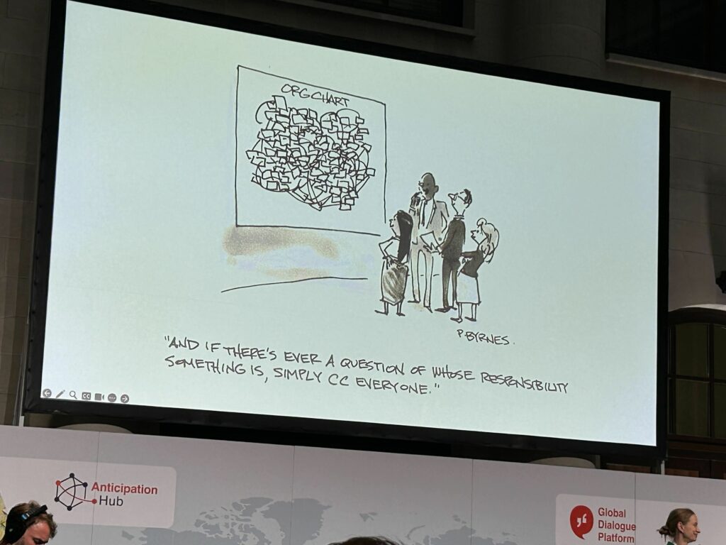
A cartoon to wrap things up for today. More updates tomorrow.
“And if there’s ever a question of whose responsibility something is, simply CC everyone.”
Day 1 wraps up with lightning talks, in which a CSO leader and an academic explore how El Niño is affecting lives, health, food security, violence and displacement of children and adolescents.
With:
Wendy Emilia Vera García, Leader, Movimiento Por Ser Niña (‘Because I am a Girl’ movement)
Liz Stephens, Science Lead / Professor of Climate Risks and Resilience, Red Cross Red Crescent Climate Centre and University of Reading
The parallel sessions are about to begin at #GlobalDP – come and join us online 👇🏾
Anticipatory action (AA) is a humanitarian term. We will use the Red Cross definition below:
“A set of actions taken to prevent or mitigate potential disaster impacts before a shock or before acute impacts are felt. The actions are carried out in anticipation of a hazard impact and based on a prediction of how the event will unfold. Anticipatory actions should not be a substitute for longer-term investment in risk reduction and should aim to strengthen people’s capacity to manage risks.”
The following are not synonymous with anticipatory action but are closely interconnectedterms: early action, early warning, disaster risk reduction, future preparedness, disaster resilience, forecast-based action, forecast-based finance.
Nepal at the centre stage of the #GlobalDP with a powerful message from the CEO of @NDRRMA_Nepal: "Nepal is keen to engage with the wider #AnticipatoryAction community to ensure we reach everyone with #EW4all and are able to save lives and reduce loss and damages" – Anil Pokhrel pic.twitter.com/CqP5hC0OLt
In the last 10 years… 410,000 people have been killed by extreme weather and climate-related events, most by heatwaves and storms. (World Disaster Report 2020)
In the last 10 years… 83% of all disasters were caused by extreme weather and climate-related events
There has been a 35% increase in climate and weather-related hazards since 1990
The East Asia and Pacific region alone includes 13 of the 30 countries most vulnerable to the impacts of climate change, according to the World Bank. “Without concerted action, the region could see an additional 7.5 million people fall into poverty due to climate impacts by 2030,” warns the international financial institution.
What can we learn from acrobats in anticipatory action? Trust, practice, learning from mistakes. Photo: MapAction.
Anticipatory action networks
MapAction volunteers attended training with INFORM in Italy in September 2023. MapAction will be working with several national disaster management agencies to build new disaster models or to update their current ones within the INFORM framework. Goal? Greater resilience. Photo: Leon Baruah.
MapAction is part of the following anticipatory action frameworks and networks:
INFORM: INFORM is a multi-stakeholder forum for developing shared, quantitative analysis relevant to humanitarian crises and disasters. INFORM includes organisations from across the multilateral system, including the humanitarian and development sector, donors, and technical partners. The Joint Research Center of European Commission is the scientific lead for INFORM. INFORM is developing a suite of quantitative, analytical products to support decision-making on humanitarian crises and disasters. These help make decisions at different stages of the disaster management cycle, specifically climate adaptation and disaster prevention, preparedness and response.
“The partnership between INFORM and MapAction greatly increases our capacity to support countries to develop INFORM Subnational risk models. These models help countries understand their risks and inform planning and programming to better prevent and prepare for crises and disasters.”
Andrew Thow, INFORM Programme Manager
Start Network: Start Network is made up of more than 80 non-governmental organisations across five continents, ranging from large international organisations to local and national NGOs. Our programmes allow members to deliver humanitarian action around the world.
Reflections from our first #GlobalDP session this year on #AnticipatoryAction processes and timelines: 💬Involve communities from start to finish of the response. 🤝Risk assessments should be participatory. 💡Disaster Risk Reduction scientific communities should be engaged. pic.twitter.com/S6ko4zysho
Anticipatory action allows communities exposed to hazards, as well as disaster managers, to be more prepared and forecast future hazards. It is a framework for disaster risk reduction and for triggering early release of funds to mitigate the effects of hazards.
Thesefour phases are regularly used components within an anticipatory action plan.
TRIGGERS: Defines when and where early action will be implemented.
EARLY ACTIONS: Defines what early actions will be taken to reduce the impact
FINANCING MECHANISM: a pre-agreed financing mechanism
DELIVERY: Capacity to implement actions as planned
Triggers are essential to activating #AnticipatoryAction to save lives and livelihoods before hazards strike.
To learn more about creating a robust trigger mechanism, join @FAO, @UNOCHA, @climatesociety and more at this workshop.
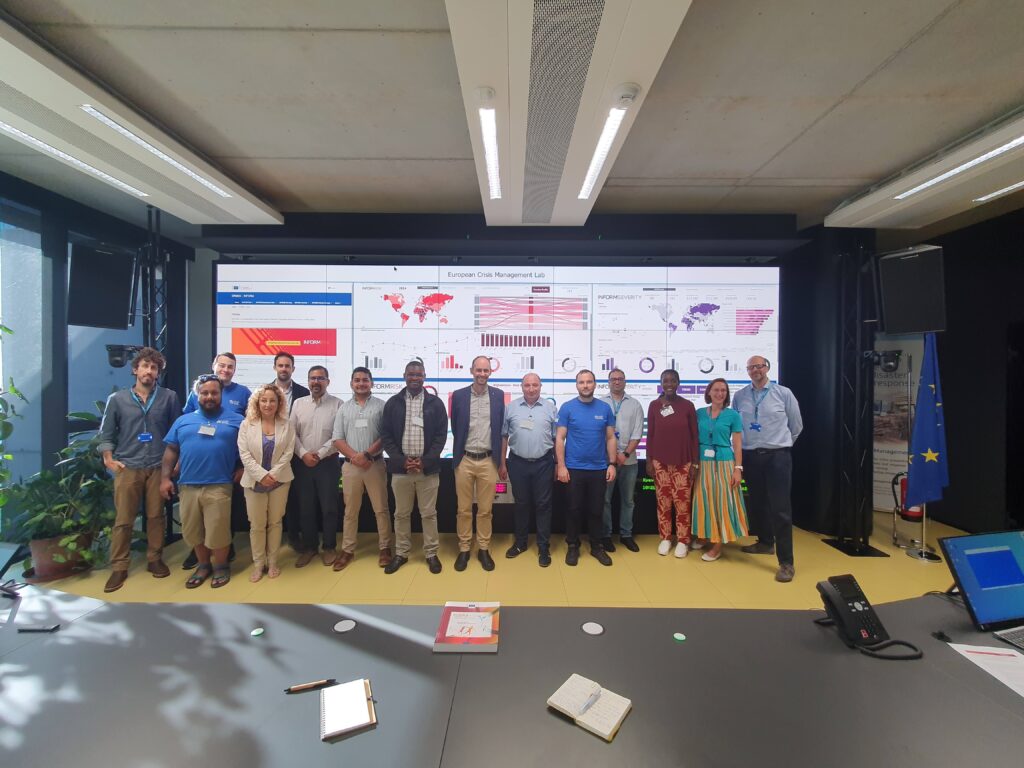
Images from the Anticipation Hub in Berlin, where a team of MapAction anticipatory action specialists – project managers, data scientists, software engineers – are in attendance. Photo: MapAction.
There are also three agreed parameters for anticipatory action:
What? The action is taken to reduce or prevent the crisis impact
When? The action is taken ahead of the hazard impact or before the impacts of the shock fully unfold (not to be confused with early response)
How? The decision to act is taken on a forecast or a collaborative analysis
MapAction’s 2022 Annual General Meeting celebrated 20 years of humanitarian service. The event in early December also served as a platform to announce the organisation’s increasing pivot towards early warning work – to consolidate global resilience to the climate emergency, health epidemics and conflict.
20 years ago a small group of people started MapAction from humble beginnings in a village in Oxfordshire. The organisation has grown – via more than 130 deployments alongside international, regional and national relief agencies – to encompass a cohort of more than 60 volunteers and 20 staff with a global footprint of projects in five continents.
In 2022 alone, MapAction was involved in responses to disasters in Paraguay, Suriname, Madagascar, South Sudan, Afghanistan, Pakistan, The Gambia and the Philippines (to mention but a few), responding to cyclones, floods, droughts, conflict and food security emergencies.
This year, MapAction volunteers and staff completed 59 projects. Our teams produced hundreds of maps and trained more than 100 professionals in GIS and data and information management worldwide. With the help of five major donors and many individual donations, we were able to work with 26 key partners globally. A majority of our cohort of volunteers attended 14 training events in the UK.
New dawn
Coming into 2022 we knew it would be an inflection point for the organisation, with different routes we could travel. Twenty years on from our beginnings, that seems appropriate.
We have had a front seat alongside emergency relief agencies in more than 130 disaster responses since we started providing maps, data analytics and IM services to humanitarian emergency relief coordinators. Thousands of maps later, we are using that experience to create new, and better, ways of working.
Grassroots resilience
Perhaps the most striking change compared to the humanitarian sector 20 years ago when MapAction was founded is the shift away from global relief agencies towards local and national leadership for response, anticipatory action and preparedness. We recognised a while back that we will not always be the ones providing the maps; others will do so. That is why we are increasingly focusing on a strategy of ‘global localisation’: supporting regional and grassroots response capacity.
MapAction works with regional and local disaster relief bodies and civil society organisations worldwide to strengthen resilience and preparedness vis-a-vis any disaster. In Asia, we work with the Asian Disaster Reduction and Response Network (ADRRN), the ASEAN Coordinating Centre for Humanitarian Assistance (AHA Centre) – an intergovernmental organisation consisting of 10 southeast Asian nations – as well as the Center for Emergency Situations and Disaster Risk Reduction (CESDRR) in Central Asia.
In the Caribbean, MapAction works with the Caribbean Disaster Emergency Management Agency (CDEMA). Equivalent projects are also underway to create partnerships and opportunities for knowledge exchange among humanitarian data analytics practitioners in Africa.
InnovationHub
We support organisations to streamline preparedness for any disaster through enhancing response with innovation and new ideas. That is why we are increasingly placing resources and energy into our InnovationHub, which identifies, prioritises and explores needs and opportunities in the humanitarian data analytics sector. Our ultimate goal is for no one to be left behind.
We see the potential of building communities of like-minded people to use geospatial and data analysis to help decision-making effectively. We wanted to globalise the wonderful data-crunching culture of MapAction, our own community of practice. Such communities can cross national boundaries working collaboratively and in solidarity to use data and tech to solve problems and answer questions
Looking to 2023
In 2023, we are already earmarked to work in Bangladesh, Burundi, Madagascar, Philippines and South Sudan on preparedness and anticipatory action, as well as on health microplanning. The calendar for next year in general is looking exciting.
In January, MapAction will lead ‘geo-surgery’ sessions as part of the State of the Map Tanzania conference. In April, our annual disaster simulation Gilded will bring together more than 50 data professionals on the Isle of Cumbrae off the west coast of Scotland. Our InnovationHub will continue to collaborate with the Predictive Analytics team at the UN Centre for Humanitarian Data to push the boundaries of innovation.
As the final days of the year loom, I can honestly say 2022 was everything we anticipated. We end the year having achieved what we set out to do, with perhaps the strongest team that we’ve ever had. We will carry this momentum into 2023, fully aware that very real challenges lie ahead of the horizon. One of the greatest challenges we will face will be to secure the resources that we need to achieve the impact that we strive for. I know that MapAction will continue to work to fill this funding gap with determination, innovation and conviction.
All that remains for me to say is to wish all of our donors, partners, volunteers, members, staff, friends and followers all the very best for the festive season. Merry Xmas!
MapAction continues to help create resilience for geospatial and data science practitioners in the Asia-Pacific region working on emergency response and anticipatory action. It is part of MapAction’s ‘global strategy of localisation’, a commitment to empower regional disaster relief bodies and civil society stakeholders to be more resilient and sustainable.
The East Asia and Pacific region alone includes 13 of the 30 countries most vulnerable to the impacts of climate change, according to the World Bank. “Without concerted action, the region could see an additional 7.5 million people fall into poverty due to climate impacts by 2030,” warns the international financial institution.
In 2021, MapAction signed a Memorandum of Understanding with the Asian Disaster Reduction and Response Network (ADRRN), a civil society partnership of 59 international and regional NGOs working in 18 countries across the Asia-Pacific region, to support that “concerted action”.
The ADRRN network, in its own words, “focuses on transforming Asia’s resilience, moving from the most vulnerable to the most resilient region’. Its influence and reach is considerably enhanced through collaboration with national-level networks, global networks, regional multilateral stakeholders and UN agencies.”
MapAction remains committed to strengthening the global humanitarian data science and geospatial sectors through partnerships with civil society networks like ADRRN. “Our joint agreement commits us to seeing how humanitarian information can help in planning and developing tools for anticipatory action and in better understanding the different contexts of emergencies, such as the difference between urban and rural settings,” says MapAction CEO Liz Hughes.
Our work so far with ADRRN has focused on improving Information Management (IM) for civil society organisations (CSOs) to have a better understanding of their existing resources, impact and plans. MapAction also supports CSOs to be interoperable with other humanitarian actors and mechanisms. This nourishes a bottom-up approach to building capacity and ability to do IM at local levels – that then regional and international agencies can support. The ultimate goal is for local stakeholders to be more resilient vis-a-vis any crisis.
MapAction continues to provide data and volunteers for emergencies in the region alongside major international relief agencies like the United Nations Office for the Coordination of Humanitarian Affairs (OCHA). But working with civil society organisations at ADRRN has additional benefits. “Doing it through a network encourages spillover approaches and techniques from one agency to another,” says Alan Mills MBE, a MapAction team member on the project. “MapAction wants to learn peer-to-peer with these agencies who come with different world experiences and perspectives from our own.”
MapAction’s partnership with ADRRN is ongoing. As part of Regional Humanitarian Partnership Week in Bangkok (jointly organised by ADRRN, CWS, ICVA and OCHA) on December 14th, MapAction will lead a session to support how people use geospatial data in emergencies. The presentation and ‘geo-surgery’ Q&A for partners will cover ‘Using location data for preparedness and response work’. In a nutshell, tips and techniques for successful geospatial work.
Geo-surgery date
A screenshot of a 3W dashboard MapAction produced for CDP in the Philippines in December 2021 following Typhoon Rai.
The session will focus on some key geospatial and data challenges faced by data scientists and geospatial data engineers when confronted with any emergency, from mapping techniques, to location surveys and establishing baseline data for the ‘3Ws’: the who-what-where baseline information that is so vital to emergency service coordinators and providers to able to make informed decisions. The session led by MapAction will look at rapid mapping techniques using software like PowerPoint, Excel, Google Earth, ESRI ArcGis (mapping software) and QGIS (an open source geo data tool).
Another Q&A with stakeholders will explore the benefits of including location in assessments, using survey tools such as Kobo. The discussion will explore how good data sources, good formatting and interoperability can all represent quick wins for geodata specialists working in disaster relief.
In the last 16 months, MapAction data volunteers and staff have been working on projects in Sri Lanka and the Philippines geared at building preparedness. In Sri Lanka we work with Muslim Foundation for Culture and Development (MFCD) and in the Philippines with the Centre for Disaster Preparedness Foundation Inc (CDP). Both projects focus on mapping their programmes and partnerships (the who-what-where baseline of information and ‘3W Rapid Mapping’) through a standardised template. Essentially, creating a clear view to pierce through the whirlpool of data.
“Not only does this provide our partners with useful information about what everyone is doing but it also provides visibility amongst the full ADRRN network and with regional and global bodies such as OCHA. During a crisis response this is useful as this information can be fed straight into the humanitarian cluster system for the 3W work, so the local civil society organisations are getting better visibility in the response and with donors – and it also fosters better interoperability between all organisations,” says MapAction’s Matt Sims, who worked on both projects.
At MapAction we are committed to building on what we already know: use of data to mitigate the devastating effects of global threats such as climate change is at the heart of why we set-up our Innovation Hub in 2022. The emphasis on innovation in how we use, source, present and process data to mitigate natural disasters aligns with stakeholder policy.
“Frontier technologies and digital innovations not only reduce the cost of implementing the policy interventions, but also have game-changing impacts on scaling up transformative adaptation through enhanced risk analytics like impact forecasting and integrated multi-hazard risk assessment and early warning, surveillance, and strategic foresights,” notes the UN’s Economic and Social Commission For Asia and the Pacific (ESCAP) Asia Pacific Disaster Report for 2022.
“Anticipatory action protects lives”
This is part of a prevailing global strategy to put data and innovation at the centre of mitigating the colossal impacts of the climate emergency, including through the promotion of disaster risk reduction and emerging anticipatory action strategies. “Anticipatory action protects lives, livelihoods, homes and entire communities. These early investments also prevent higher response costs down the road. This is at the core of my prevention agenda — to put better data, and more innovation, foresight and inclusion, into our work to address major risks,” affirmed UN Secretary-General António Guterres’ in a video message for a UN event on Anticipatory Action in September 2021.
MapAction’s work with ADRRN is part of a broader institutional strategy to engage and partner with regional and local disaster relief bodies and civil society organisations worldwide. Since 2018, MapAction has worked extensively with the ASEAN Coordinating Centre for Humanitarian Assistance (AHA Centre), an intergovernmental organisation consisting of 10 southeast Asian nations.
MapAction also works with the Caribbean Disaster Emergency Management Agency (CDEMA) in the Caribbean, as well as the Center for Emergency Situations and Disaster Risk Reduction (CESDRR) in Central Asia. Equivalent projects are also underway to create partnerships and opportunities for knowledge exchange in humanitarian data science in Africa.
MapAction is helping CSOs put together the building blocks for more coherent management of information between all pillars of humanitarian actors. One of the key goals of all our partnerships with local and civil society organisations is to ensure that they can efficiently contribute to that sharing of vital information on local action which often gets overlooked by global audiences. Our collaborative work with ADRRN and others in the Asia Pacific region is helping to create that solid foundation from which more innovative and interoperable solutions can emerge.
As part of a growing trend, humanitarians are now anticipating crises and acting prior to their onset, enabling faster, more dignified and more cost-effective humanitarian responses. Using data and analytical approaches we can now predict humanitarian shocks brought about by extreme weather, conflict and a range of other sources with increasing confidence.
Geospatial data, data visualisation and information management are critical to this type of anticipatory action. As a trusted leader in these fields MapAction has been selected to partner with Start Network to assist with their programmes of anticipatory and early action.
MapAction will use its expertise to provide hazard data analysis, real time hazard data, base maps and vulnerability analysis to the network. Together, we aim to provide locally led anticipatory action to enhance the coordination of disaster risk nationally.
The three year programme will see MapAction providing Start Network with data for eight vulnerable countries where it is implementing anticipatory finance projects. This will involve MapAction providing local information and visualisations for critical early decision making as well as implementation support.
Liz Hughes, MapAction’s CEO, said, “We are very excited to be working on this project as we believe it can make a real and lasting difference for disaster affected populations. MapAction will provide Start Network and its members with a combination of historical and real time hazard data analysis, vulnerability analysis, maps and more. By converting all of that into usable situational information and visualisations for critical early decision making, we can enable better informed humanitarian decisions, and ultimately save lives and reduce suffering.”
This work is being made possible by a consortium of partners including members of the Insurance Development Forum and Swiss Re Foundation, who aim to improve global risk understanding in order to help create equal opportunities and sustainable growth.