Key facts (October 03 08:50 UTC)
- More than 4,000 dead and 10,000 people missing in floods in eastern Libya caused by Storm Daniel, according to UN OCHA. Estimates of the number of deaths vary, according to different sources: they range from about 4,000 to double or triple that amount, according to the International Medical Corps
- Two dams collapsed on Sunday September 10th due to torrential rains and flooded the city of Derna, 300 kilometres east of Benghazi
- 250,000 people affected
- 100,000 people food insecure
- MapAction humanitarian mappers were working alongside UN teams in Cairo and Tunis to support the response
- MapAction’s Libya flood-related maps repository outlined which roads were passable, accumulated rainfall, and affected areas in the governorate of Derna, among other key data points
- $19 billion is the estimated infrastructure damage caused by the floods in Derna
- Read about our ongoing Humanitarian Response Appeal here
- UNICEF: 17,000 children displaced by the floods
- SEE ALSO: Morocco earthquake response maps here
- Read the latest MapAction newsletter or subscribe
- *This blog will no longer be regularly updated.
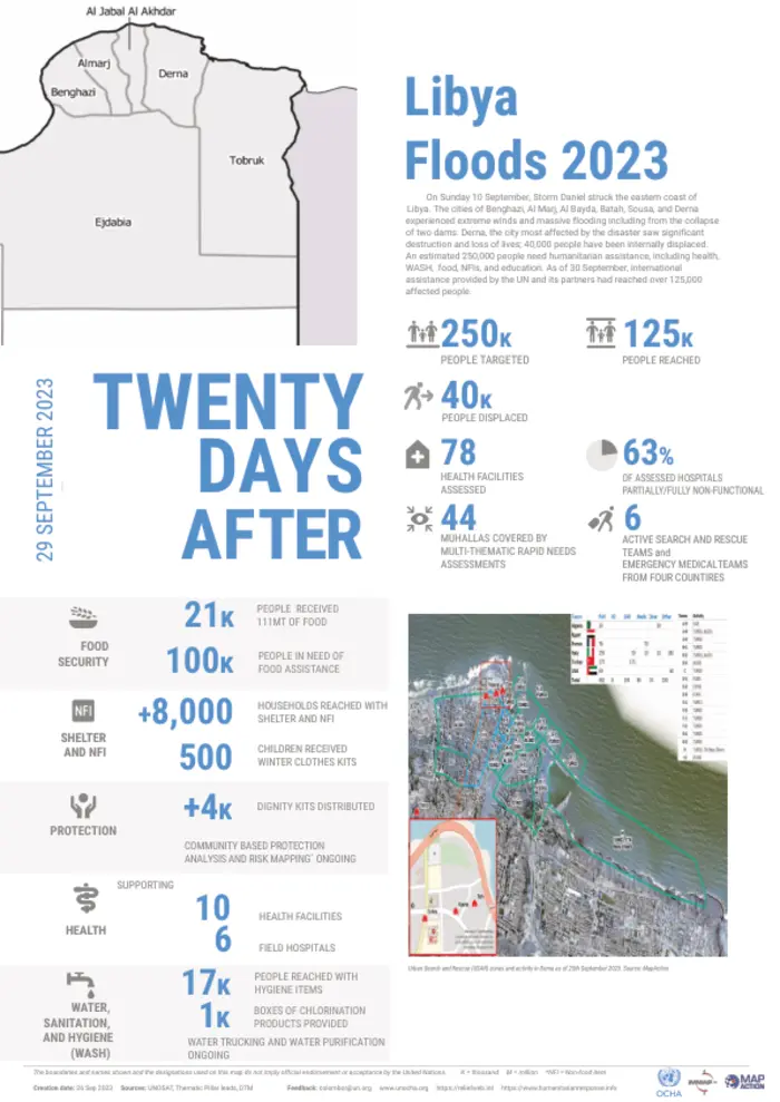
October 3. 08:50 UTC: OCHA delivers comprehensive assessment of Libya floods, supported by MapAction
The latest update from UN OCHA, MapAction’s UN partner on the Libya flood response, outlines some key data points and highlights the devastation and damage caused by Storm Daniel.
250,000: people affected
40,000: people displaced
63%: Partially or non-functional hospitals or health facilities
125,000: people reached
100,000: people in need of food
September 28. 11:35 UTC: “This was a complex mission.” MapAction team leader
“This was a complex mission that required a lot of snap decisions and flexibility, but that’s what we do. We’ve managed to work alongside our UNDAC and NGO partners to determine how people are affected, where they are, and what they need with nearly 600 key informants providing information on their areas,” said MapAction volunteer and Libya response team-leader Chris Jarvis.
September 28. 11:20 UTC: “…mighty MapAction volunteers.” We second that ode to our volunteers! Nice and humbling to receive such positive feedback from partners.
SEE MORE: MapAction Libya repository of flood-related maps
September 28. 08:00 UTC: MapAction mappers return to UK after supporting UN response to floods in Libya
Our team of humanitarian mappers has now reverted their attention to previous projects, having worked on the response to the floods in Libya alongside the UN for the last two weeks. We will be bringing you some of their final thoughts today.
September 26. 18:25 UTC: 50%+ of all health facilities in Libyan regions affected by floods damaged or non-functional
More than half of the assessed health facilities in Al-Marj, Derna and parts of Al-Jabal Al-Akhdar are reported either partially or totally non-functional due to #StormDaniel.
Our latest Flash Update highlights the on-going relief efforts➡️ https://t.co/kmaIMFDVxl #Libya pic.twitter.com/emN5lIokQr
— OCHA Libya (@OCHA_Libya) September 25, 2023
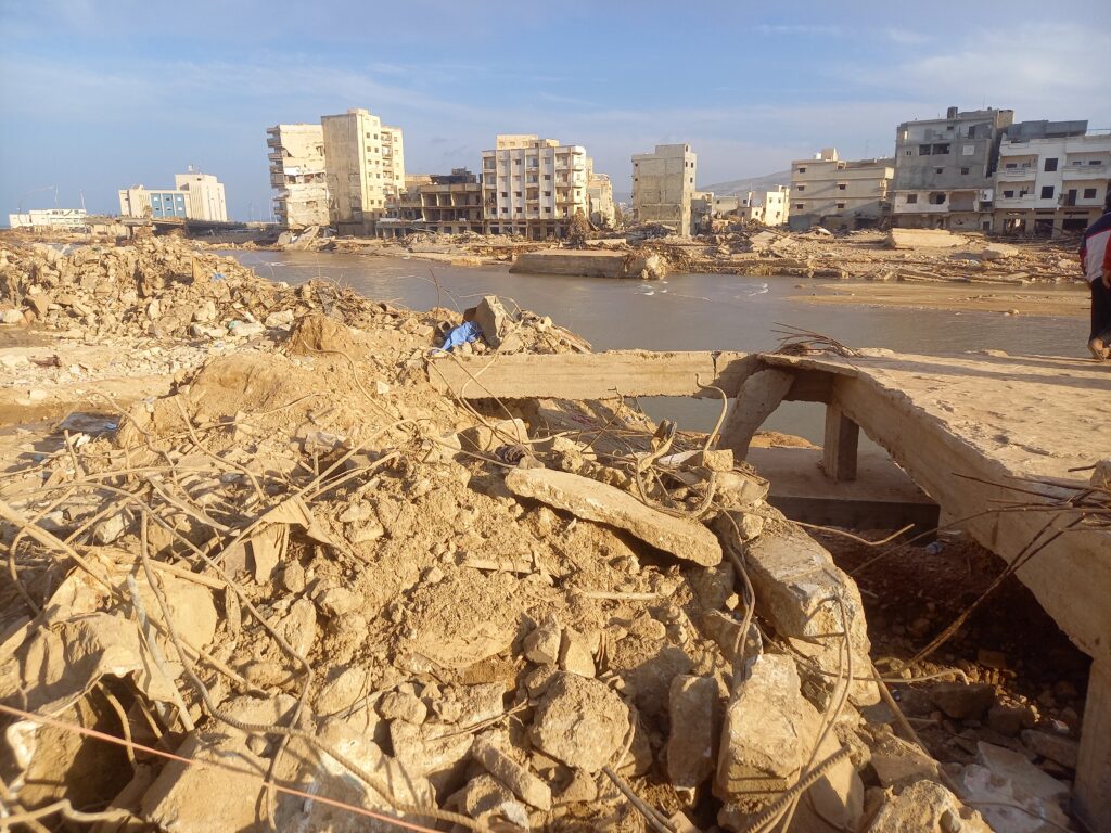
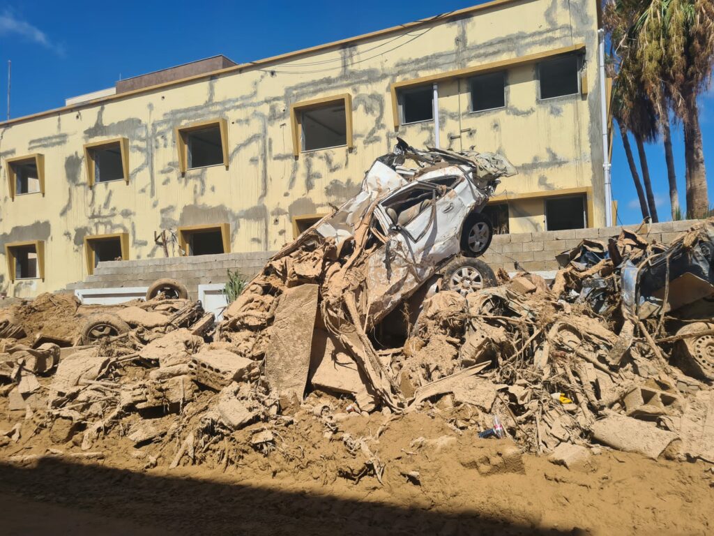
September 26. 10:30 UTC: Devastating images from Derna
Emergency relief efforts continue in #Derna and other flood-ravaged areas of #Libya.@UN and partners are
➡️ setting up field hospitals
➡️ distributing core relief items & food
➡️ chlorinating water reservoirs
➡️ providing psychosocial supportMore: https://t.co/d0EvfoyAog pic.twitter.com/PKz6g3daM0
— UN Humanitarian (@UNOCHA) September 25, 2023
Following the recent earthquake in #Morocco and the extensive flooding in #Libya ,the Club has agreed to make charitable donations of £500 to @mapaction and @ShelterBox who are assisting with recovery. https://t.co/OpYoBaoVws
— Tonbridge Rotary (@rotarytonbridge) September 25, 2023
Thank you very much Tonbridge Rotary Club. If you’d also like to support our work, you can make a donation below. Or read about our Humanitarian Emergency Response appeal here.
September 25. 09:00 UTC: Nearly 20,000 children displaced by floods, UNICEF estimates
Of the 43,000 people displaced by the floods, UNICEF estimates that at least 17,000 may be children, states an update from UN OCHA from the weekend.
“WHO conducted a rapid assessment of 78 health facilities in affected areas, including Al-Marj district, Derna city and part of Al-Jabal Al-Akhdar. More than half of the facilities were reported either partially or totally non-functional due to shortage of medical supplies, medicines, equipment or staff, damaged buildings and limited accessibility,” states the same update.
September 22. 15:15: Aid is reaching Derna.
(The below is from a UN OCHA press release)
“UNICEF shipped 65 metric tons of life-saving medical supplies and water, sanitation and hygiene items, child protection supplies and delivered emergency medical kits to primary care services to support 15,000 people for three months and hygiene kits for almost 1,000 people and 500 clothing kits. Mobile psychosocial support teams are being set up with social welfare authorities and two NGO partners.
The UN Refugee Agency (UNHCR) is distributing blankets, plastic tarpaulins and kitchen equipment to 6,200 displaced families in Derna and Benghazi.
The World Food Programme (WFP) has distributed food rations to more than 9,000 people. This includes dry rations to cover their food needs for 15 days.
The World Health Organization (WHO) shipped 28 tons of medical supplies and donated ambulances and medical kits. In addition, a WHO team met with the health authorities in Derna today and agreed to prioritize mental health support to help people cope with the distress they experienced during this catastrophe.
The International Organization for Migration (IOM) has delivered non-food items to nearly 3,000 migrants and displaced persons. The agency also delivered medicines and supplies for 5,000 people in Derna and 4,000 families in Benghazi.”
September 22. 15:00 UTC: The focus of the MapAction Libya flood response team’s maps has shifted towards creating Assessment Area Units. These maps help decision-makers get a better picture of who is worst affected and where, and therefore how to prioritise the delivery of aid. It helps decision-makers get the granularity required for responding to those in need, rather than just providing a blanket response. Assessment needs to be localised enough to make sense.
“It’s similar to what you’d do during an aerial survey where you break up the area,” says MapAction team leader Chris Jarvis, recalling an aerial survey exercise in Mozambique during the response to Cyclone Idai in 2019 that led to this map. Learn more about that aerial survey in this ICRC video.
READ ALSO: MapAction supports Cyclone Idai response
September 22: 14:55 UTC. In case you missed the news, MapAction staff and volunteers were in the beautiful Italian town of Ispra for training with INFORM. INFORM is “a multi-stakeholder forum for developing shared, quantitative analysis relevant to humanitarian crises and disasters” that is “developing a suite of quantitative, analytical products to support decision-making on humanitarian crises and disasters.”
#MapAction staff and volunteers are attending a training event with INFORM in Italy this week. #INFORM is a multi-stakeholder forum for developing shared, quantitative #analysis relevant to humanitarian #crises and #disasters. #MapAction is a partner. #disasterpreparedness pic.twitter.com/aIdoDZ6VcX
— MapAction (@mapaction) September 21, 2023
September 21. 12:10 UTC.
September 21. 10:55 UTC. UPDATE FROM MAPACTION TEAM LEADER CHRIS JARVIS ON THE LIBYA FLOOD RESPONSE TEAM
Chris Jarvis, Libya flood response team leader for MapAction, explains how the response is moving out of the search and rescue phase and into the assessment phase. “This is where we try and get more information about what are the needs of the different people,” says Chris. Designing surveys and putting questions together for those affected is a key part of this information-gathering phase. Listen below to the full explanation.
Just in: According to the latest IOM update, an estimated 43,059 individuals have been displaced by the floods in #northeastern Libya. Lack of water supply is reportedly driving many displaced out of Derna to eastern and western municipalities.
Read more: https://t.co/TDWQONaIpa pic.twitter.com/zuxE6j8VbU— IOM Libya (@IOM_Libya) September 21, 2023
September 21. 10:50 UTC: $19 billion estimated in infrastructure damage
Significant infrastructure damage estimated at $19 billion affected 2,217 buildings, including 284 educational and 128 health facilities in and around the city of Derna, according to an update from NGO Data Friendly Space published on Relief Web.
“Immediate needs are in health, food, water, shelter, with vulnerable groups such as children and displaced persons requiring specialised assistance,” adds the update.
Ten days following #StormDaniel:
🔴About 4,000 people confirmed dead. We fear the actual toll is much higher
🔴Nearly 40,000 people displaced
🔴Risk of disease outbreaks due to contaminated waterFind out about how humanitarians are responding: https://t.co/WIxu9QkixE pic.twitter.com/NvxCKsiAdx
— OCHA Libya (@OCHA_Libya) September 20, 2023
September 20. 13:55 UTC: “So far, around 1,500 people in Derna and Benghazi have been assisted with core relief items including blankets, plastic tarpaulins, kitchen sets, hygiene kits and clothes,” reads a statement published yesterday from the United Nations High Commission for Refugees (UNHCR). An airlift from UNHCR’s warehouse in Dubai was scheduled to arrive on 19th September in Benghazi with relief items to assist 10,000 people, adds the update on the UN’s Relief Web service.
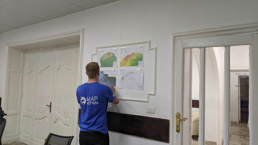
September 20. 13:25 UTC: Partners from iMMAP, Atlas Logistique and the United Nations Disaster Assessment Coordination (UNDAC) office, peruse the recently-established MapAction MapWall. MapAction mapping volunteer Alice Goudie offers a guided tour.
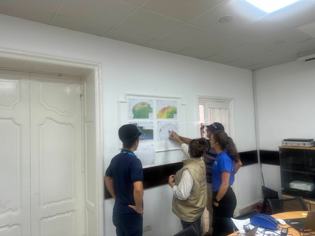
September 20. 13:15 UTC: Where MapAction humanitarian mappers go, a MapWall soon follows. Below is Chris Jarvis, team leader for the Libya response, setting one up at a UN emergency operations room in Cairo.
SEE ALSO: More from the MapAction Libya floods repository of maps
September 20. 10:30 UTC: This map by MapAction’s team of Libya-focused humanitarian mapping volunteers working with the UN shows all the dams in eastern Libya, including the two collapsed dams that caused the major floods in the city of Derna. Those floods have killed at least 4,000 people.
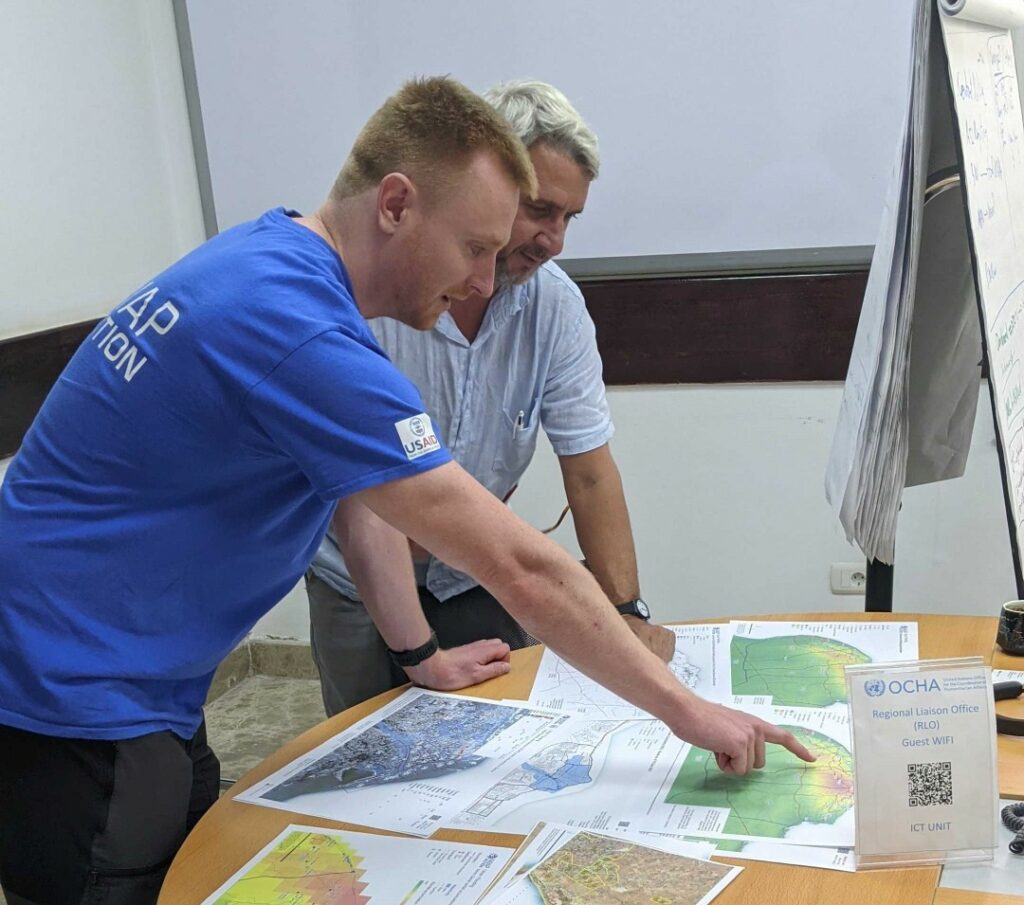
September 20. 09:40 UTC: Chris Jarvis (below in the MapAction t-shirt), team leader at MapAction for the Libya response, tells us in the video below why MapAction’s work matters and how it makes a difference in such emergencies.
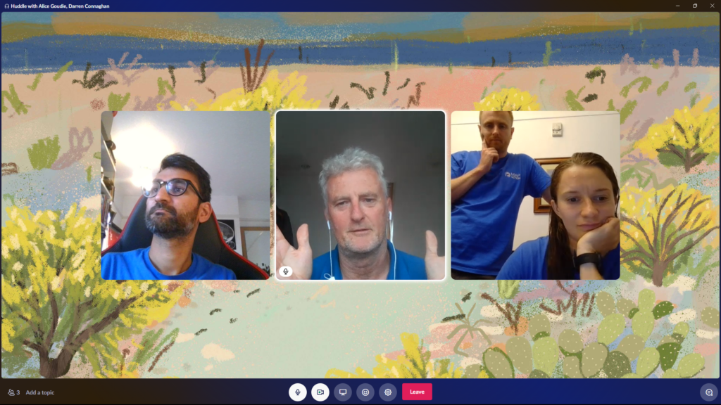
September 19. 16:15 UTC: MapAction’s work is not only about being on the frontlines of emergencies. Each mission is also supported by a remote team. In the image below, the remote support team for Libya, formed of Sam Gandhi (left) and Darren Connaghan, touch base with Alice Goudie and Chris Jarvis, who are in Cairo working alongside the UN.
September 19. 10.10 UTC: MapAction’s team of mappers are in Cairo working alongside UN personnel to map some of the key incoming data from Derna. This helps support the vital decision-making process in the temporary emergency operations room.
MapAction’s cohort of 70+ volunteers, all experts in GIS and data management, undergo extensive humanitarian training with MapAction all-year round before being deployed to any crisis or natural disaster. Every year, the majority of our volunteers, old and new, come together for a disaster simulation event too. This year’s was a simulation for a volcanic eruption, held on the Isle of Cumbrae in Scotland.
READ MORE: MapAction conducts simulated volcanic eruption response exercise on Isle of Cumbrae
READ ALSO (in The Herald Scotland): Isle of Cumbrae becomes training ground for disaster response
September 19. 09:15 UTC
⚠️ Following extreme rainfall and flash flooding in northeast #Libya, we have created a dedicated page with datasets shared by @hotosm, @UNOCHA, @mapaction, @UNOSAT, @GoogleAI and others.
🔎 Explore Libya Floods data on #HDX: https://t.co/4mdb02x5kp pic.twitter.com/zw6f3HGZUV
— OCHA Centre for Humanitarian Data (@humdata) September 19, 2023
September 18. 16:35 UTC: UNDAC Team Leader Nabil Chemil tours Derna and outlines some of the challenges: location of bodies, preventing disease outbreaks and provision of clean water are all priorities. MapAction teams have worked with Nabil before, including during the earthquake response in Turkiye, and will be supporting the United Nations Disaster Assessment Coordination (UNDAC) office’s work in the continued response to the devastating floods in eastern Libya.
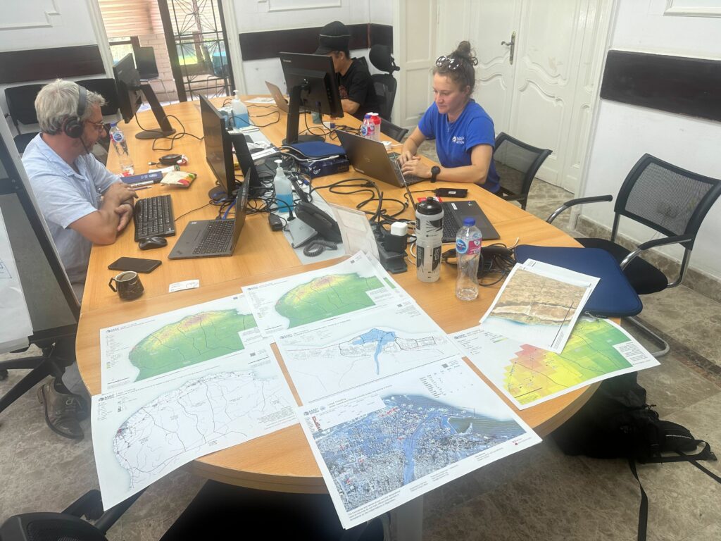
September 18. 16:10 UTC: Many of the maps our remote team are publishing help paint a clearer picture of what humanitarian responders face to administer aid, create shelters or reach survivors. The map below outlines how the floods caused by Storm Daniel made many roads in the city of Derna unpassable.
NEWS: Today, @POTUS announced $10M in additional humanitarian aid from @USAID to help the Libyan people affected by #StormDaniel's devastating #flooding. This assistance will provide food, shelter, water, healthcare, hygiene & more to communities in need. #LibyaFloods pic.twitter.com/KgYs1bIeAe
— USAID's Bureau for Humanitarian Assistance (@USAIDSavesLives) September 18, 2023
September 18. 16:00 UTC: There has been some confusion regarding the total death toll caused by the floods in Libya, as reported by this article. The latest figures, from the UN’s Relief Web service, state that 3,958 people have been killed and 9000 are missing in the floods.
The same source suggests that, according to the latest data from IOM’s Displacement Tracking Matrix, more than 40,000 people have been displaced across northeastern Libya. UNICEF says 300,000 children exposed to Storm Daniel now face increased risk of diarrhoea and cholera, dehydration and malnutrition, as well as increased risks of violence and exploitation. Read more here.
🆘#Libya floods: Entire neighbourhoods in the city of Derna have disappeared after the devastation from #StormDaniel.
WFP and our partners have been on the ground distributing emergency food to impacted families. https://t.co/Pyqnf7aWFn
— World Food Programme (@WFP) September 17, 2023
September 15. 12:00 UTC: The floods in Libya caused two dams to burst, apparently sweeping away whole parts of the eastern Libyan city of Derna. The UN Resident Coordinator requested MapAction’s help; an alert then went out among MapAction’s deployable team of disaster mappers, to see who was immediately available. A team was placed on standby. Security assessments completed. Specialist insurance, visas and tickets acquired. MapAction expects to send disaster mapping personnel to Libya to work alongside the UN as soon as logistically possible.
#MapAction #mapping volunteers will support the UN response to the devastating #floods in #Libya. The floods have already killed more than 11,000 people. https://t.co/FORaN3uawM
— MapAction (@mapaction) September 15, 2023
It has been a devastating week in North Africa. The fatal floods in Derna, Libya, caused by Storm Daniel, and the earthquake in Morocco, have seen MapAction publish more than a dozen maps of the affected disaster areas. More than 7,000 people have been confirmed dead in the Maghreb region of Africa due to both natural disasters in the last week.
As of Thursday a spokesperson for the Libyan Red Crescent placed the death toll at more than 11,300, reports the Associated Press. More than 10,000 people are also reported missing. Those figures have since been disputed and updated. (See above)
A remote team of MapAction mappers continues to work in support of Morocco, which was struck by a 6.8 magnitude earthquake on the night of Friday September 8th. According to the latest update (7pm, Wednesday September 13th) from the Moroccan Ministry of the Interior, that earthquake, the epicentre of which was in a hard-to-reach region between Agadir and Marrakech, has already claimed 2946 lives. MapAction alerted its volunteer cohort, began to publish maps for humanitarian responders and has a team on standby to deploy.
Unexpected disasters like the ones in Libya and Morocco this week are the reason MapAction works all-year-round to build resilience to disasters locally. This summer alone we have held disaster preparedness and resilience-building events in Nepal, Senegal, Philippines, Bangladesh, Kazakhstan and Madagascar.
READ ALSO: MapAction continues to strengthen global disaster preparedness in summer of 2023
It is also why we are working to make countries and regions vulnerable to such disasters more resilient, through better use of data.
MapAction works on disaster preparedness 24/7, all-year-round. From the team that cancelled Christmas to rush to DRC (Democratic Republic of Congo) in response to flooding, to those helping local communities to become better prepared for disasters, those delivering training, or advocating for better use of data for humanitarian response. We do the technical work that ultimately helps others save more lives. If you like the work we do and would like to support that work, or think you know somebody who would, please get in touch. MapAction doesn’t have the funds it needs, and the demands of responding to natural disasters are only getting greater. Read more in our appeal here.