 MapAction has now completed its humanitarian mapping mission in response to the Nepal earthquakes. Over the course of our four-month mission, 13 volunteers and staff have created more than 110 maps and contributed 230 days of expertise.
MapAction’s Operations Director, Emma Mumford, reflects: “The challenges for this response have been particularly acute due to the difficult mountainous terrain and the prevalence of landslides during the monsoon season, which quickly followed the earthquakes. The team has achieved a great deal in supporting the coordination and programming of aid for those affected. Although our physical presence in Nepal has come to an end, we remain in close contact with our partners to explore how we can contribute to this and future emergencies.”
You can read Emma’s full supporter update below.
************************
MapAction: Nepal earthquake response
“As the Clinical Lead for the UK’s disaster response in Nepal I never failed to be impressed and grateful for the fantastic and invaluable information provided by the MapAction team. Every evening and through the night the MapAction team would input information from our daily recces and create a new map for our recce the next day. I would receive a new map by email in the early hours of the morning and several copies would be left for me at 0600 in the MapAction tent. Fabulous service.”
Dr Sean Hudson, Clinical Lead, UK Emergency Medical Team, UK-Med
Key facts and figures
- On 25 April 2015, an earthquake of 7.8 magnitude hit Nepal.
- It was the worst natural disaster to strike the country since 1934.
- More than 8,800 people were killed and more than 23,000 injured.
- An estimated 450,000 people have been displaced.
Thanks to the support of the UK Government’s Department for International Development (DFID) and people like you, MapAction was able to respond immediately. Over the course of our four-month mission, 13 MapAction mapping experts have created more than 110 maps and contributed 230 days of expertise.
How the mission unfolded
On 25 April 2015 Nepal was struck by a devastating earthquake, which was followed by further quakes and aftershocks. Within 24 hours of the first earthquake the United Nations (UN) had made an official request for MapAction to deploy with its Disaster Assessment and Coordination team. We were fortunate that one of our MapAction volunteers was on site in Kathmandu and diverted immediately to help. Two further volunteers deployed to Kathmandu the following day.
 Dr Hamish Pritchard, one of MapAction’s most experienced volunteers, had been working on a glacier mapping project for his ‘day job’ on the south side of Kathmandu when the earthquake struck. He immediately transferred to the Urban Search and Rescue (USAR) Base of Operations near the airport to support initial coordination efforts. As one of the first people at the scene, Hamish drew on his experience of helping at other humanitarian emergencies (including the Haiti earthquake) to provide mapped analysis to help coordinate search and rescue efforts.
Map left: Urban Search and Rescue Sectors as of 29 April 2015
As the full scale of the emergency became clear, MapAction sent further volunteers to reinforce the field team. Nigel Woof was one of the first volunteers to arrive in-country. He commented:
 “In terms of the scale of this disaster, more than 8,000 are known to have lost their lives with around half a million people estimated to have lost their homes and pretty much everything else. In this respect we are getting flashbacks to the Kashmir earthquake in 2005 where we faced similar issues. We’re trying to create a picture of damage and needs across an affected area about the size of Wales – but imagine a Wales with 5,000-metre peaks and access routes challenged by landslides and earthquake damage.”
Photo right: MapAction volunteer, Nigel Woof, working into the night
 With widespread destruction caused by the earthquake, MapAction volunteers lived in tented accommodation positioned outside the United Nation’s coordination hub. This was where incoming responders came to get critical analysis regarding the extent of impact and what other responders were doing in-country. Our initial focus was to help coordinate search and rescue efforts to avoid gaps or duplication. The team also created mapped analysis about the areas which had been worst affected by the earthquake to help prioritise and target the response.
MapAction’s Royal Patron, Prince Harry, sent a message of support for our volunteers working with fellow responders on the humanitarian response in Nepal. He commented: “I have been deeply saddened to hear of the terrible loss of life and damage caused by the earthquake over the weekend. My thoughts are with all those who have lost loved ones and the many thousands who have been left homeless as a result of this tragedy.” He went on, “I also wanted to send my sincere thanks and best wishes to all of you who are engaged in the difficult and dangerous job of finding those still missing and supporting the injured.”
 From 4 May onwards, MapAction decided to split the team, with some team members travelling to areas of priority need. Three volunteers remained in Kathmandu while two travelled to Chautara and Sindhupalchok close to the earthquake epicentre. Outside the capital, the damage was extensive and all too evident. In Chautara, the hospital had been particularly badly hit, so a temporary field hospital had been set up on a playing field. It was next to this field hospital that international responders set up their coordination hub and where MapAction set up camp.
Photo right: MapAction’s mapping centre in Chautara
Six weeks into the response, MapAction completed its final volunteer rotation for the emergency phase of the mission. Recognising that there was still great humanitarian need, two further MapAction mapping experts were deployed on longer assignments to support assessment and information analysis, working in partnership with ACAPS[1] and OCHA[2] and hosted by the Nepali government. These experts have been providing spatial analysis and mapping know-how to convey critical situational information about the ongoing needs of affected communities.
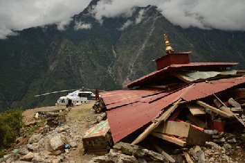
This second phase of our response coincided with the arrival of the monsoon season, causing landslides and disruption for already vulnerable communities. MapAction’s mapped products and analysis helped responders understand the needs of communities in hard-to-reach locations, many of whom could only be reached via helicopter or porters.
Looking forward, MapAction has also been helping plan for the likely impact of winter for affected communities. Around 150,000 people live in areas where the average January temperature is 5 degrees Celsius or less, making it a priority to ensure that durable shelters are provided before the winter arrives.
The needs remain great in Nepal and MapAction continues to maintain a dialogue with our counterparts in-country, however as of 27 August the MapAction mission has come to an end. MapAction volunteers and staff have been working closely with humanitarian partners to ensure that they have the mapping know-how to be able to carry activities forward without our presence in the field. We are also in discussions with key emergency management teams to explore training requirements to support future responses. So while the mission has come to a close, our partnerships will continue well into the future.
On behalf of everyone at MapAction, thank you for your very kind and generous support. I’m incredibly proud of what our volunteers and staff have achieved for the Nepal earthquake response. I know your support means a great deal to them too. We do not receive any funding through large national appeals, so every penny you donated has made a big difference to our work.
Please do keep up-to-date with MapAction’s news on our website: www.mapaction.org or follow us on Twitter (@mapaction) or Facebook. Thank you again for your support.
Emma Mumford, Operations Director
[1] ACAPS supports and strengthens humanitarian capacities to carry out better coordinated assessments before, during and after crises.
[2] OCHA: United Nations Office for the Coordination of Humanitarian Affairs