December 18 marks The United Nations (UN) International Migrants Day, recognising the efforts, contributions, and rights of migrants worldwide. In light of this, we decided to share some of the work we did this year during the Syria crisis to highlight some of the challenges of meeting the needs of migrant populations, and also explore the role that maps can play when people are displaced from their homes.
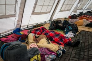
MapAction was asked by the UN’s Office for the Coordination of Humanitarian Affairs (UN OCHA) to send a team to Turkey. Their mission: to help humanitarian teams there and in Northwest Syria supporting almost one million people – 60% of them children – that arrived in the region during January-March 2020, following an upsurge of fighting in Aleppo.
A population displacement of this scale and speed results in great vulnerability for those involved, as well as many unknowns for humanitarians about people’s access to essential things like food, water, sanitation and shelter. And that’s before you factor in the added complication of COVID.
MapAction was asked to support two groups of humanitarian organisations collaborating to manage around 1,000 refugee camps – the Camp Coordination and Camp Management (CCCM) Cluster, and the Shelter /Non-Food Item (SNFI) Cluster.
Camps vary enormously, from just a few tents to the size of a small city, and from temporary to long-term settlements. Some are isolated, while others are grouped together. Getting clean, up-to-date data about them is essential for the Clusters to coordinate life-saving aid.
MapAction’s aim was to grant the Cluster coordinators a ‘single source of truth’ about the locations and sizes of the camps, to enable them to understand their population density and meet the needs of the people arriving and living in them. The imminent threat of COVID-19 made this even more urgent and important – not to mention more difficult.
‘Data cleaning’ is a vital part of the process. Camp data is often captured by collectors with varying levels of training, network connectivity and other obstacles. Sometimes geographical coordinates are estimated from a central location instead of using GPS, or transcribed manually, introducing human errors. The same data might be captured several times by different organisations, with different results. All of this can make it difficult to pinpoint the exact locations of camps and could cause them to be missed or double counted, resulting in delays or complete omissions in aid delivery.
Camps vary enormously, from just a few tents to the size of a small city, and from temporary to long-term settlements. Some are isolated, while others are grouped together. Getting clean, up-to-date data about them is essential for the Clusters to coordinate life-saving aid.
The MapAction team compared a core list of 700 sites against a further list of 600 camps, and used GIS analysis to deduplicate against location, site name and then visually against the latest satellite imagery, to confirm locations. Over three iterations, they were able to support the CCCM Cluster to improve the core list from 700 to around 1,000 sites.
To aid this process in Syria, our team created two data tools. One helped to identify anomalies in the camp location coordinates. The other automatically performed location analysis, determining in which Administrative District each camp was situated. As a result of creating these tools, they were able to save 60-70% of the time it took to manually clean and assess camp location data – around half to one day of a Cluster team member’s time, once or twice a week – freeing them up for higher value tasks. They also enabled faster identification of unrecorded camps, speeding up the delivery of aid to people in need.
Next they drew polygons of the camps, mapping their size and extent. This major task, involving creating digital maps of most of Northwest Syria using OpenStreetMap imagery, gave context to the coordinates. It hadn’t been done before and was described by the Clusters as “fantastically helpful”.
Migration mapping resources
The above describes the outputs of one MapAction mission in support of displaced people. To support the various aid agencies we work with, we also publish resources about the types of maps that can be helpful in different humanitarian situations, and information about their use.
These resources include: core maps; maps to help with work in humanitarian clusters, and specifically, where there is vulnerability or access problems during a response (e.g. food, shelter, water and sanitation, etc.); and maps that are produced in response to a particular hazard such as armed conflict.
In the case of migration, population maps, including baseline population, languages and population displacement maps, are often the most relevant. These maps may be produced in response to extensive population displacements driven by natural disasters, political unrest or a complex emergency situation. They are both strategic and operational in nature and can help all responders coordinate camps and aid response planning, including effective communication with affected people.
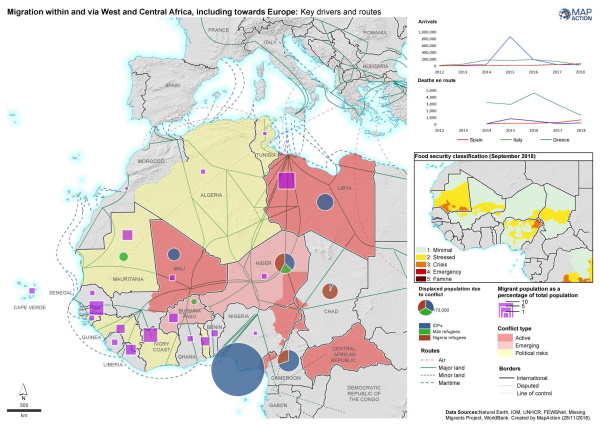
When it comes to migration, there are some things to bear in mind when mapping. For example, where migration is because of political persecution or war, recording camp boundaries and tagging them on a widely available map could pose a serious security risk. In these instances, it is common for some camp locations not to be shared.
Thought should also be given to the most effective way to depict on maps the movement of groups who may go through different phases of displacement. In these cases, infographic methods of sharing the data may be more suitable than maps, showing summary information and key issues without publishing sensitive locational data.
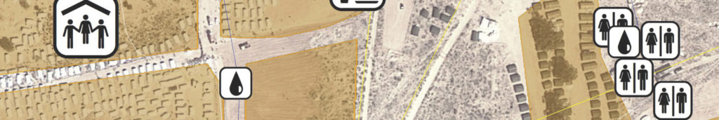
Cluster maps are used in conjunction with core maps and can specifically show where there is a particular or probable vulnerability or access problem during a response, e.g food, shelter, hygiene facilities. Within this, the camp coordination or camp management cluster helps inform planning and operation of camps. They may show camp population figures, infrastructure, hazards or resources. Planning of camp locations is driven by many spatial factors including safety and access to resources.
According to the UN Office for the Commissioner on Human Rights, an estimated 258 million people, approximately 3% of the world’s population, currently live outside their country of origin, with an increasing number being forced to migrate due to a complex mix of issues including poverty, water, food and housing. We will continue to seek and develop ever more effective mapping and geospatial data tools to support our partners who are working tirelessly to help people caught up in any situations that cause them to leave their homes.
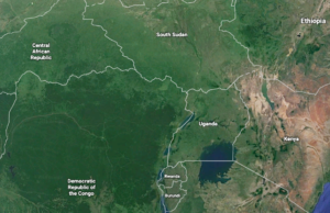
 A two-person MapAction team flew to Kampala, Uganda last week to provide mapping and information management support to humanitarian teams responding to a major refugee crisis in the region. This follows a recent upsurge in conflict in the eastern part of the Democratic Republic of Congo (DRC), causing significant displacement of people into Uganda, a country that is already contending with a large influx of refugees from South Sudan. Around 1.9 million people have fled DRC since the start of 2017, with 242,000 being hosted in Uganda. The United Nations Office for the Coordination of Humanitarian Affairs (UN OCHA) estimates that 13.1 million people are in humanitarian need within DRC.