MapAction responds to drought and food crisis in Kenya

Source: ASAL Humanitarian Network Drought Response


A serious drought is affecting parts of East Africa. Three consecutive failed rainy seasons has meant crops are failing, livestock is being badly affected and cereal prices are rocketing.

A drought warning has already been issued for many parts of northern and eastern Kenya – a mainly rural area with already high rates of poverty. Forecasts indicate that the food security situation is only likely to get worse, meaning that many more households will soon be in need of urgent humanitarian assistance.

MapAction’s support was requested by the Arid and Semi Arid Lands (ASAL) Humanitarian Network – a group of more than 30 local Civil Society Organisations (CSOs), community groups. Together with its partners (ACTED, Concern Worldwide and Oxfam), they are focused on the dry ASAL region of Kenya which has been particularly badly affected. More than 2.9 million people are at risk of going hungry and losing their livelihoods here, and thousands of young children are in urgent need of treatment for acute malnutrition.

A large part of the response has involved multi-purpose cash transfers to communities which are aimed to boost the local economy, and protect lives and livelihoods. So far it has reached over 5,000 affected households.

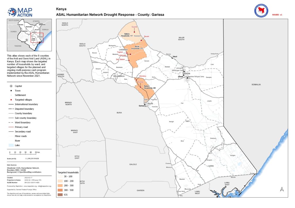
Since November 2021, MapAction has been supplying information management to the ASAL Humanitarian Network to support this response. We have provided tools to help manage their data on the response which then meant this information could be mapped. Once the information was on a map we could verify the data and this subsequently allowed the response to be presented at detailed village and ward level, rather than at regional level. This level of detail in our visualisations showed which partner was responding where, in which village location and what the response entailed.

MapAction also analysed and mapped the baseline drought survey commissioned by ASAL Humanitarian Network in November 2021. This survey assessment showed indicators such as the length of drought, and the impact of drought on crops, livestock and conflict. Mapping these indicators allowed the survey information to be visualised and compared across sub-counties highlighting key issues that the drought has impacted.

By mapping the drought response at various geographic levels, we were able to communicate the impact of the programme in a powerful way. This allowed ASAL Humanitarian Network to share these maps with partners, donors and within the network itself to explain and also help drive decision making.

The maps produced from this programme can be seen here.

As well as increasing prospects of drought, many of these very dry arid and semi-arid areas have been degraded from deforestation and overgrazing, which further reduces the productivity of these lands. This threatens food security, livelihoods and biodiversity. Early action from MapAction and other agencies aims to prevent loss of life and sustain livelihoods in these areas.

MapAction is grateful to the German Federal Foreign Office for funding this work.

Communicating humanitarian needs and impacts in Eastern and Southern Africa

For over a year, swarms of locusts have been ravaging large parts of rural Africa, affecting different countries at different times. Stripping the land of vegetation and destroying crops and food supplies, the highly destructive pest is causing additional severe food insecurity for communities already struggling to recover from drought and flooding, as well as coping with COVID-19.

Since April, MapAction has been working with Oxfam and its network of local civil society partners in Eastern and Southern Africa to help improve visibility of the work the partners are doing and improve communication flows between them, even during COVID lockdowns. This in turn is helping them to protect people’s food security, livelihoods and access to water, sanitation and hygiene (WASH) services as this complex and many-layered crisis evolves.

As well as mapping who is doing what and where to help, we have also been creating map templates and training people locally so that they can update and refresh the maps on an ongoing basis. This means that Oxfam’s partners can alert each other of threats such as locust swarms migrating into new areas.

In Somalia we have been assisting teams working on food security, livelihoods, WASH and protection by helping to triangulate information about locust infestations and areas affected by COVID. In Southern Africa, we have been helping Oxfam and its civil society partners set up and then maintain situational awareness of locusts and other threats to food security across the region.

One Oxfam project MapAction has been supporting involves mapping water ATMs – machines that allow water to be automatically dispensed when a customer places his or her token or card against an electronic reader, which regulates flow at a dispensing point. A chip within the token or card contains information about the amount of water the user has already paid for and water credits are deducted each time water is dispensed.  The water ATMs are important points in areas such as informal settlements, ensuring access to safe, low-cost drinking water which is key in protecting people against water-borne diseases. Initially covering informal settlements around Nairobi, MapAction’s involvement has now extended to mapping ATMs in other areas.

Irene Gai, WASH strategist at Oxfam, said, “Sharing where work has been done is helping to avoid duplication of interventions, thereby saving resources that can be channelled to other needy areas. By having the maps shared with other WASH-sector agencies, they can target their own resources for similar initiatives in other places than where Oxfam has already supported.”

During the course of the work in East Africa, the MapAction team created our first automatically-generated maps, testing out this new approach which is part of our ambitious Moonshot programme. Among other things, this enables us to produce the best reference and baseline maps possible in almost no time at all, freeing up team time to focus on the specifics of the situation at hand.

German Humanitarian Assistance logo

Initially supporting Oxfam’s partners’ work in Kenya and Somalia, MapAction personnel are now also helping in Zimbabwe and Zambia, with scope to roll out to Malawi, Mozambique, Namibia, Angola, South Africa and Botswana. Additional projects in other countries may also take place.

We’re grateful to the German Federal Foreign Office for funding this work.