What is MapAction’s ‘humanitarian data landscape?’ At MapAction, we’re working to put data at the centre of how we provide products and services to the humanitarian sector. MapAction’s data scientist, Monica Turner, recently posted about the work she does in this new role. However, data is a big (and sometimes loaded) term. So what does ‘data’ mean to MapAction? We asked Hannah Ker, MapAction’s Data Scientist whilst Monica is on maternity leave, to explain.
During a humanitarian crisis, it is vitally important for responders to have information such as which areas are most affected, where vulnerable populations exist and where relevant infrastructure & services (such as healthcare facilities) are located. MapAction provides information products (such as maps) to our partners to help them address these information needs. Unsurprisingly the vast majority of data that we work with at MapAction is geospatial. We aim to use geospatial techniques, such as cartography, to make complex data rapidlly accessible to those responding to humanitarian crises.
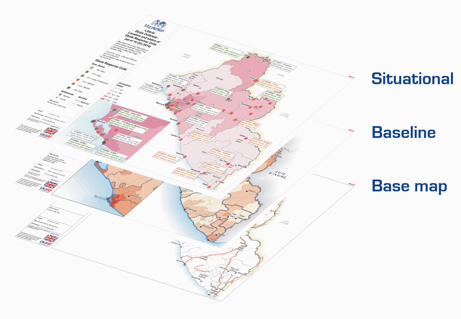
The ‘Layers of data’ page (see diagram below) from our Example Product Catalogue provides a useful framework for thinking about how many different datasets are processed and combined into a meaningful final product.
Firstly, we can think of the data that is input to our basemap or initial reference map of a given area. This data often reflects features such as administrative boundaries, land elevation, settlements, and transportation infrastructure. Secondly, we have baseline data that provides demographic information about the area of interest, such as population numbers and numbers of schools.
Our last data layer includes situational information that is relevant to the humanitarian context at hand. The kinds of data relevant for this layer can vary significantly depending on the circumstances. This data is also likely to be the most dynamic and temporally sensitive. For example, it may be used to show change over time as a crisis evolves.
All of this data can come from a variety of sources. The Humanitarian Data Exchange (HDX), developed and maintained by the UN OCHA Centre for Humanitarian Data, is a repository that holds over 17,000 datasets from more than 1,300 different sources. These datasets come from what we might think of as ‘authoritative’ sources of information, such as the World Bank or the World Food Programme.
In particular, MapAction frequently uses the Common Operational Datasets of Administrative Boundaries (COD-AB) that are published and maintained by the UN Office for the Coordination of Humanitarian Affairs (OCHA). It can be challenging to access complete and up-to-date administrative boundary data, so the CODs attempt to provide standardised, high quality data that can be used to support humanitarian operations.
OpenStreetMap (OSM) also provides a valuable source of geospatial data. This ‘Wikipedia of maps’ is an entirely crowdsourced map of the world. In theory, anyone, anywhere in the world (with an internet connection) can contribute to OSM. At MapAction, we use OSM as a source of data for features such as settlements and transportation infrastructure. MapAction is a partner of the Missing Maps project, hosted by OSM which seeks to crowd source the gaps in maps in available maps.
So why can’t we just use maps that already exist, like Google Maps?, one might ask. Why all these complex data layers? Why spend so much time finding data when it’s already all there?
Platforms such as Google Maps, Waze, and Apple Maps are commonly used as day-to-day navigation tools for people in many parts of the world. However, such existing tools do not provide the flexibility that is often required when managing and presenting geospatial data in humanitarian scenarios. As these tools are privately-developed, individuals and organisations do not always have the ability to manipulate or style the underlying data to suit their needs. These platforms were not created specifically for humanitarian use-cases, and so may not always include the information that meets the operational requirements of humanitarian contexts, such as locations of damaged buildings or the extent of a flood.
OSM’s Humanitarian map style, for example, shows some of the unique data styling that may be required in humanitarian contexts. Moreover, there are many parts of the world with human settlements that are not present (or poorly represented) on existing maps, as is demonstrated by efforts from organisations such as the Humanitarian OpenStreetMap Team and the Missing Maps initiative. These challenges mean that there is no existing ‘one size fits all’ mapping platform that is capable of providing and presenting all of the information that is needed in humanitarian contexts.
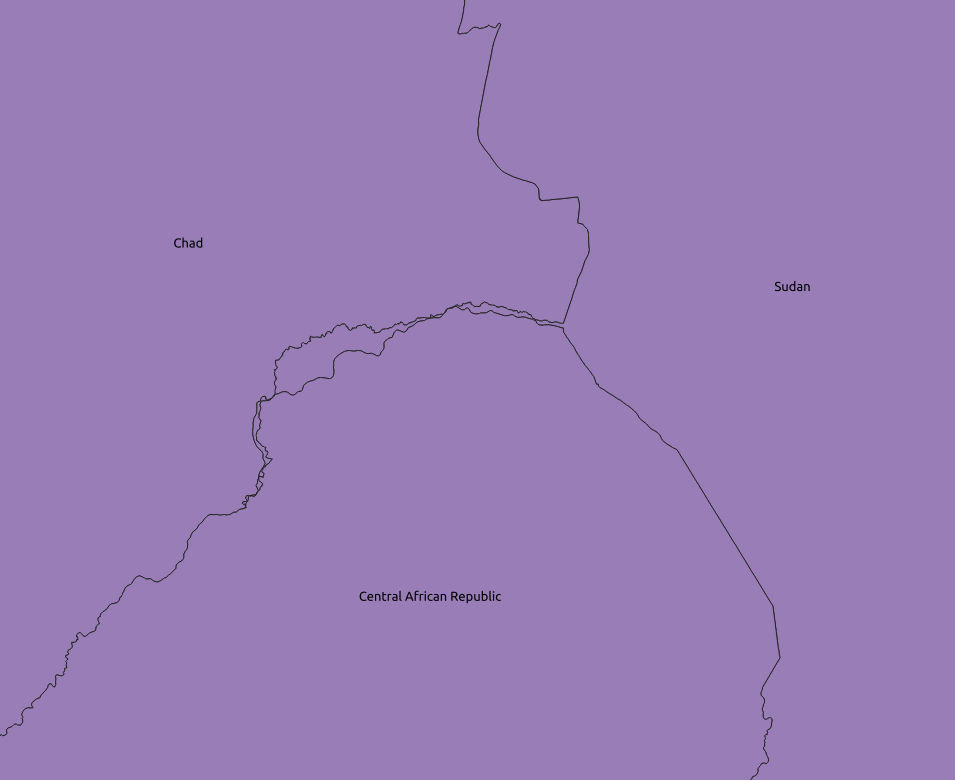
Finding high quality geospatial data is an ongoing challenge for us at MapAction. Geospatial data quality is a multifaceted concept, and includes dimensions such as up-to-dateness, positional accuracy, logical consistency, and completeness. The image below, for example, shows a geometry problem that we often face with administrative boundary data. Notice the gap in the border between Chad and the Central African Republic. Lack of standardisation in this data between different countries and organisations, or out of date data can result in such misalignment. Due to the political sensitivity that is associated with boundary data, it is important to ensure that the data that we use is as accurate as possible.
Our ongoing work around the Moonshot project seeks to develop tools that can help us to automatically detect and address quality issues such as these. Keep an eye out for future blog posts where we will address some of these technical challenges in greater detail.
At the end of the day, we’re working to make complex situations better understood. Humanitarian crises are incredibly complex, and accordingly, can be associated with complex datasets and information. By selecting high quality datasets and visualising them in clear and accessible ways, we intend for our humanitarian partners to be able to make informed decisions and deliver effective aid to those in need.
MapAction’s Data Scientist is funded by the German Federal Foreign Office (GFFO), but the views and opinions above do not necessarily represent those of the GFFO.