MapAction streamlining data management in DRC to improve the lives of millions of displaced people

MapAction volunteer Darren Conaghan (left) in Kigali with Information Management Officer Giresse Likunde during the latter’s onboarding in early June 2025. Image: MapAction

As part of a new project funded by UK Aid Direct through the H2H humanitarian network, MapAction is working in the Democratic Republic of the Congo to strengthen the institutional understanding of humanitarian needs through data.

MapAction has begun a new project to support the information management needs of the humanitarian community in the eastern Democratic Republic of the Congo (DRC), working closely with the United Nations Office for the Coordination of Humanitarian Affairs (OCHA), other UN agencies and local NGOs. 

MapAction’s latest recruit, Information Management Officer Giresse Likunde, working out of Goma –  together with a remote MapAction global team  – will support several UN and humanitarian agencies, bringing MapAction’s 20 years of humanitarian mapping and data management expertise to this troubled corner of the Democratic Republic of Congo.  

A 2022 MapAction map of administrative boundaries created during a response to floods in DRC. The North Kivu region, where Goma is situated, is in the eastern part of the country near the border with Rwanda. Map: MapAction

READ ALSO: MapAction team deploys to Democratic Republic of Congo (DRC) to support UN response to floods

Decades of conflict, drought, floods and poverty have left 5.6 million people displaced in DRC, according to UNHCR data. The Displacement Tracking Matrix (DTM), created by the International Organisation of Migration (IOM) in 2013 and which MapAction will support with new data sets and dashboards, in April 2025 monitored nearly 1.5 million displaced people just in the South Kivu province in eastern DRC, states an IOM report.

“The Displacement Tracking Matrix (DTM) is a system to track and monitor the displacement and population mobility,” states IOM’s website. “It is designed to regularly and systematically capture, process and disseminate information to provide a better understanding of the movements and evolving needs of displaced populations, whether on site or en route.” 

Eastern DRC poses its own unique challenges. “In places like Eastern DRC, where needs are high, access is limited, and trust is fragile, the H2H model offers a scalable, cost-effective way to support frontline response,” says H2H Executive Director Kim Scriven.  “H2H members deliver targeted services that help responders act quickly, equitably, and effectively. This activation underscores how modest investments in enabling services can strengthen the collective response,” adds Scriven. 

“With this new project, MapAction is bringing its years of experience working in the humanitarian sector and its well-proven volunteer model to give direct and operational support to one of today’s major crises,” adds MapAction Head of Data Analytics Daniel Soares

Besides the work with OCHA, the CCCM Cluster and IOM, the project will see MapAction scope adapting an Earth Observation Flood Mapping Tool to DRC too. 

“Cartography transcends language,” says MapAction’s latest recruit Giresse Likunde, who will be coordinating MapAction’s work with agencies on the ground out of Goma. “This project can truly help the coordination of humanitarian emergency response in eastern DRC,” added Likunde, who recently completed onboarding with longtime MapAction member Darren Conaghan in Kigali. 

This programme will run until late 2025 and is funded by UK Aid Direct via the humanitarian support H2H network

Mapping COVID crises with GIMAC

So far, the COVID-19 pandemic has reportedly caused 214 million illnesses and killed nearly four and a half million people worldwide (Google statistics). The impact on the poorest and most vulnerable people is immense, especially where populations are already facing several humanitarian crises. 

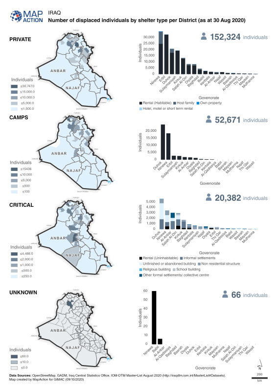
Maps and charts showing a breakdown of the number displaced individuals in private accomodation, camps, critical shelters or unknown in Iraq as at 30 August 2020

MapAction has been working with GIMAC (the Global Information Management, Assessment & Analysis Cell) which was set up by several UN agencies and other international bodies to coordinate, collate, manage and analyse COVID-19 related information. The organisation also established a ‘field support’ mechanism, available to 25 countries currently implementing a Humanitarian Response Plan. On the ground, this meant providing technical support to a number of countries already facing significant ongoing humanitarian problems and keen to update their plans in light of Covid-19.

MapAction’s role was initially funded by the H2H network, and saw us assimilating the rapid data collection to provide GIS mapping and spatial analysis to support good decision-making. To do this, one of our team was seconded to the programme for two days a week. 

As well as helping to gather initial data, we also used our GIS skills to provide mapping and other visualisations to countries on an open source basis. 

Our work on the programme is now coming to a close but throughout our time on the programme, we provided extensive geospatial analysis and data visualisation support. Overall we produced and provided around 60 maps and graphics on the impacts of the virus and any secondary shocks, alongside the ongoing humanitarian crises. These included baseline populations, food security levels, public security and educational accessibility.

Fawad Hussain, GIMAC Coordinator, OCHA, said, “MapAction has provided exceptional support to GIMAC and the country teams and it has been a pleasure to work with Matt and other MapAction colleagues.” 
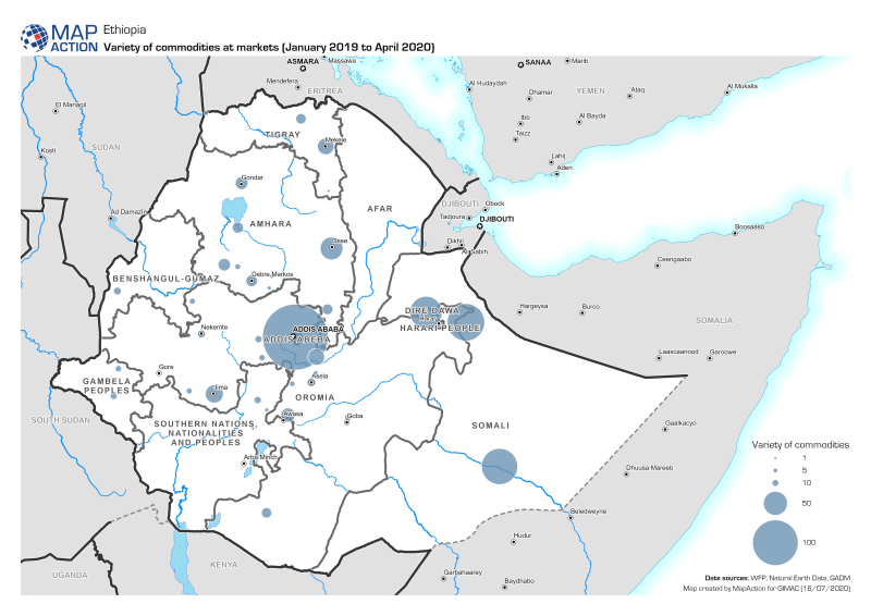
Map showing the variety in the number of commodities being sold in market places in Ethiopia January 2019 to April 2020.