 In a disaster situation, making rapid sense of the avalanche of information is crucial to an effective response.

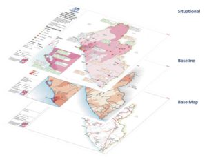
MapAction’s practical, three-day Response Mapping course teaches you to use simple, low-cost, open source software and tried and tested field applications to create essential maps, proven to aid key decision-makers in a major crisis.
When: 1 – 3 May, 2018
Or: 9 – 11 October, 2018
Where: MapAction’s offices in Saunderton, Buckinghamshire, UK
Who should take this course?
Sudden onset responders and development practitioners who want to improve their knowledge of mapping, data collection and data visualisation in the context of humanitarian response, as well as people with an interest in data mapping who want to apply their knowledge in a humanitarian context.
What will I learn?
The course will teach you how to carry out basic spatial data collection, spatial analysis and mapping and how to find the necessary free/open-source tools and software needed to set up a GIS project.
Learn how to make maps that help with:
• Field-based navigation and needs assessment
• Identifying areas in priority need of aid and gaps in delivery
• Planning and monitoring programmes
• Support to logistics
• Identifying hazards and security risks
• Reporting, communication and advocacy
All course materials and software will be provided. Computers and GPS units can be loaned if needed, but you are encouraged to bring your own laptop on which open-source software can be installed. During the course you can research data and set up a project around your area of interest, so making it easier to apply what you learn directly to your work.
The course covers:
• Mapping and information management for responders and humanitarian work
• Creating base maps using open source mapping and QGIS software and online data sources
• Creating thematic maps showing humanitarian situations
• Using GPS/smartphones to undertake field data collection
The principal course instructors will be GIS practitioners with MapAction field experience in humanitarian emergencies. MapAction has deployed to over 70 sudden onset/humanitarian disasters and supported as many again remotely. We are a stand-by partner to the UN Disaster Assessment & Coordination (UNDAC) team and we provide mapping training to UN OCHA, UNDAC, INSARAG and many other organisations with responsibility for humanitarian disaster management.
Practicalities, fees and registration
The course will be held at the MapAction office in Saunderton, Buckinghamshire, which is easily reached by train from London and Birmingham. Lunch and refreshments will be provided, as well as one evening meal for all delegates. Costs are as follows:
| Course only | All inclusive*** | |
| Band A: Student / Unemployed / Small Charity* | £360 | £740 |
| Band B: Self–funding Individuals / Medium Charity** | £600 | £980 |
| Band C: Large Charity / Commercial & State Organisations | £950 | £1330 |
* Defined as having fewer than 25 employees
** Defined as having fewer than 45 employees
*** Course plus local hotel with bed, breakfast and evening meal (Monday evening to Thursday breakfast). Daily taxi transfer to and from hotel.
Places on this course are limited. To book a place, please here and select ‘tickets’ (subject to Eventbrite booking fee), or email training[at]mapaction.org to book direct.