November 14 is GIS Day – an international event for users of geographical information systems (GIS) technology to demonstrate real-world applications that are making a difference in society.
To mark the day and celebrate the impact that GIS has in humanitarian work, we’re sharing ‘Seven days of GIS’.
Each day for the next seven days we will reveal a favourite map, a fascinating fact or a story about how GIS is used to help prepare for and respond to humanitarian emergencies.
Day 1) 8 November – floods in Malawi
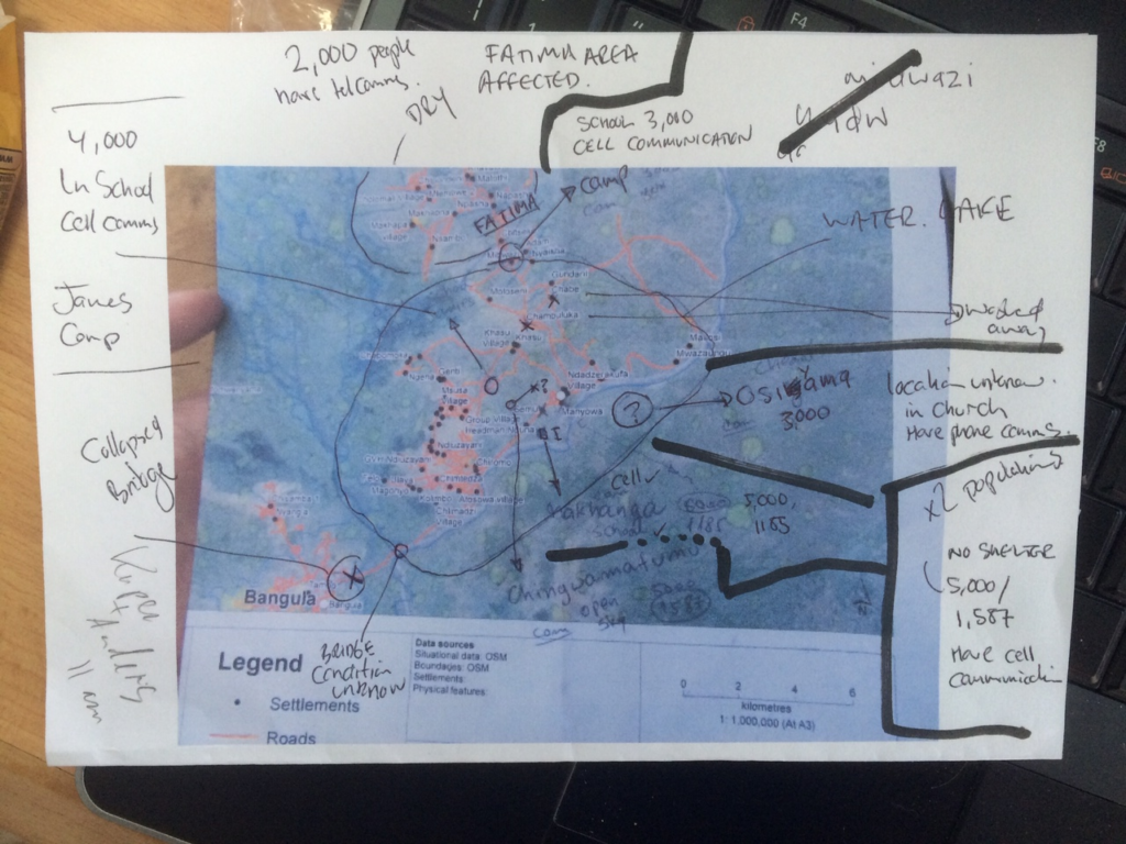 In January 2015, MapAction volunteer Andreas Buchholz was one member of a MapAction team that traveled to Malawi to help the response to catastrophic flooding.
This map turned out to be vitally important to the UN and other teams responding to the situation on the ground.
Andreas chose to highlight this map for GIS Day because “it influenced decision makers on a local, national and global level to decide where to distribute and prioritise aid.”
Click on the map to see the story.
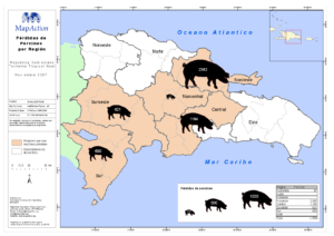
Day 2) 9 November – livestock map
 David Spackman was MapAction’s first employee in 2002 and led its first major deployment to Sri Lanka following the tsunami that devastated the country in January 2004.
David chose this map from 2007 because “it makes a powerful point, often lost in the focus on human tragedies: if you lose your livestock you lose your livelihood.”
The map was created as part of MapAction’s response to Tropical Storm Noel which caused severe flooding and displaced more than 64,000 people in the Dominican Republic in October 2007. More than 80% of the country was affected. In total we created around 50 maps that helped local responders get aid to where it was needed as quickly as possible and begin the recovery process.
Day 3) 10 November – Mark’s busy year
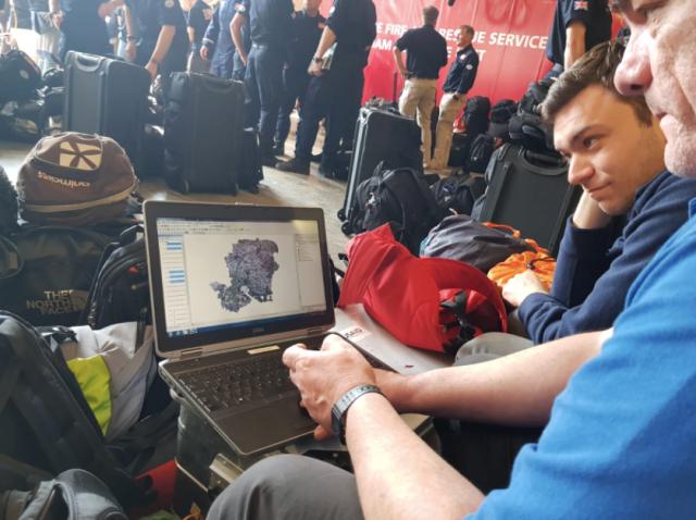 MapAction volunteer Mark Gillick has had a busy year so far, putting his GIS skills to life-saving use around the world. Since August alone, he has deployed to Indonesia, Nigeria and Afghanistan and delivered humanitarian mapping training in Laos and Kazakhstan.
Find out more about where he’s been and the difference it’s made by clicking on the photo.
Day 4) 11 November – language mapping
The ability to communicate with populations affected by disasters and emergencies effectively is key to understanding their needs and keeping them informed of life-saving information.
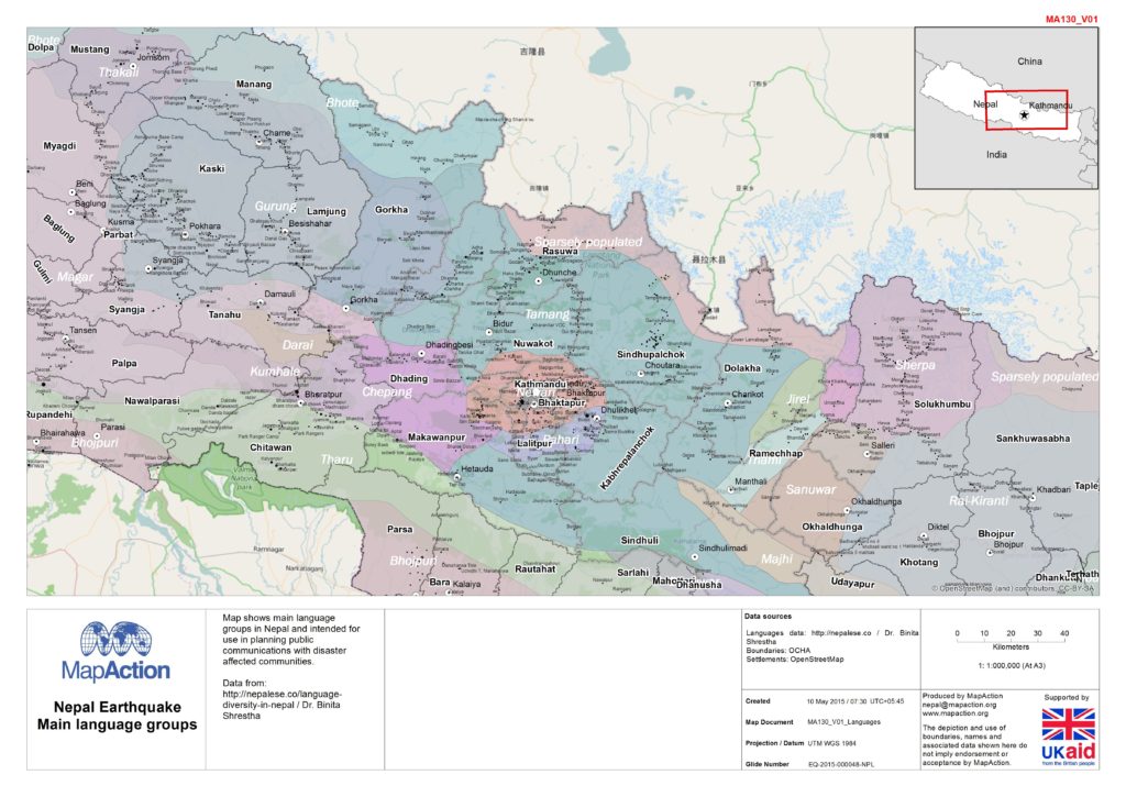 A language map is a good example of a map that might be needed in the aftermath of a disaster. It is likely to be used by anyone interacting with the local community, particularly international responders who may be unfamiliar with the affected area. Emergency telecommunications clusters may use it to help inform the best positioning of new infrastructure.
Mappers can pull in language data from resources such as Ethnologue and national censuses and combine it with administrative boundaries and settlements and communications infrastructure data.
This map was created by MapAction during the response to the earthquake in Nepal in April 2015. It shows the main language groups in Nepal and was used for planning public communications with disaster-affected communities.
Click on the map to find out more about language mapping.
Day 5) 12 November – coordination maps
 MapAction’s CEO Liz Hughes strongly believes that maps are key to making effective operational decisions. “But they need to communicate simply, quickly and clearly and the data needs to be right, or it can have serious implications.”
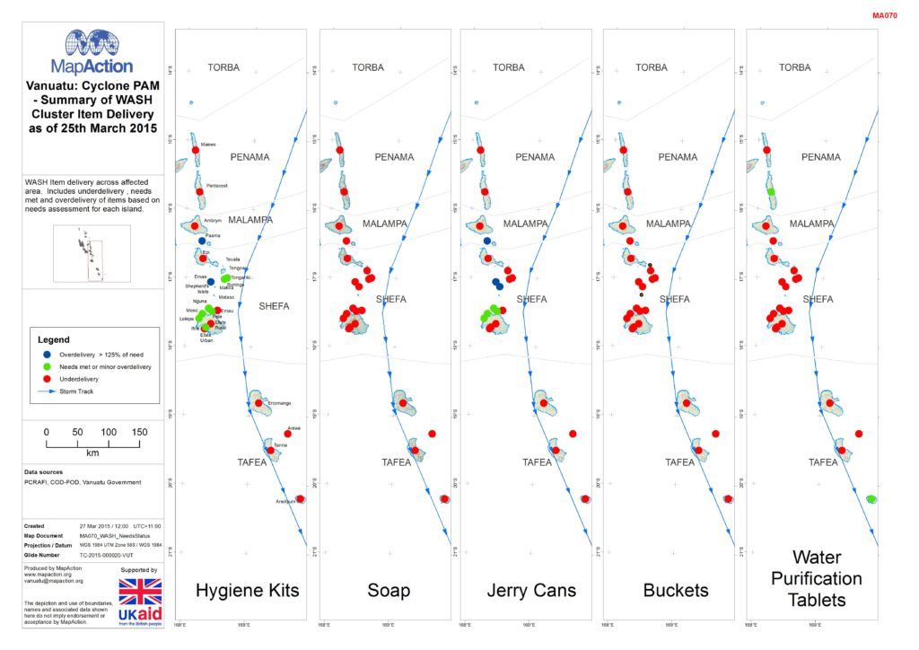
Liz chose to highlight this map from the aftermath of Cyclone Pam in Vanuatu in March 2015 because it shows how useful geospatial analysis can be in quickly understanding needs and coordinating the response in a chaotic post-disaster situation. Knowing what others are already doing to help is essential to targeting aid effectively.
Liz explains, “This map lets you quickly see gaps and also where more coordination is needed. It’s good to know that we can use our amazing team’s skills to provide useful analysis of this sort.” MapAction created well over 100 maps to help coordinate the response to Cyclone Pam, which was one of the worst natural disasters the island of Vanuatu had ever experienced.
Day 6) historic map
 MapAction trustee Barbara Bond is an author and geographer whose senior leadership roles have included president of the British Cartographic Society, senior civilian Director and Deputy Chief Executive of the UK Hydrographic Office and Chair of the International Hydrographic Organisation’s Antarctic Commission. Among other accolades, she has received the British Cartographic Society’s silver medal and the Prince Albert I medal and been inducted into the US National Geospatial-Intelligence Hall of Fame.
Barbara’s PhD thesis, ‘Great Escapes: the story of MI9’s Second World War escape and evasion maps’, was published in October 2015 by Harper Collins.
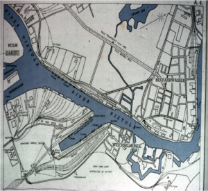
One of Barbara’s all time favourite maps is of the Danzig Docks and was produced by MI9 during the Second World War for escaping prisoners of war. The map shows the place that Swedish boats docked. Barbara explains, “It carries the most powerful message about the best way to get home (board a Swedish ship and get to a neutral country.) That map saved many lives since hundreds (even thousands) of prisoners of war successfully escaped via that route.”
Day 7: GIS Day – our volunteers
MapAction’s work depends on a group of highly skilled and dedicated volunteers who are ready to be deployed at very short notice anywhere in the world, with a select few providing specific technical capacity (system administration and software development).
In their day jobs, our volunteers work in a range of fields from Antarctic surveying to zoological research. When they join our team they are already proficient and experienced in GIS or a related subject. We train them to apply those skills in a humanitarian context.
Being a MapAction volunteer is as demanding as it is rewarding. A humanitarian response requires a huge team effort to work; MapAction team members can find themselves helping at a remote and challenging location or working through the night to provide support to our deployed team. Between missions volunteers participate in monthly MapAction training courses to update and expand their skills, as well as teaching and passing on their knowledge to humanitarians around the world. The time commitment is high, but the sense of community and satisfaction means people stay with us for many years. As longstanding volunteer Emerson Tan comments in this video, “You can’t beat the feeling of seeing some people who are alive because of your work.”