 UK, 5 Dec – MapAction is collaborating in a project with infoasaid to map the media and telecoms landscapes of 22 developing countries vulnerable to humanitarian crises to enhance humanitarian response.
infoasaid is a consortium of Internews and the BBC World Service Trust. Their objective is to improve how aid agencies communicate with disaster-affected communities – the focus is on providing humanitarian information. The emphasis is on the need to deliver information, as aid itself, through the most appropriate channels.
The aim of the project is to produce a series of tools, including country-specific media and telecommunications guides, to help humanitarian agencies communicate effectively with crisis-affected communities. Each country guide identifies local media organizations, telecommunication companies and other media service providers that can help to produce and disseminate radio shows, TV programs, SMS messages, poster campaigns or public service announcements to communicate with local communities in a timely, accurate and well-targeted manner.
In virtue of this collaboration, MapAction is literally putting much of this information onto maps to enhance humanitarian response. The maps, which will be accessible both on- and off-line, are produced by collating technical data from radio stations and feeding it into a mapping system developed by infoasaid. This innovative humanitarian tool, to be launched in early 2012, will display the geolocation of local media outlets and provide available contact information for each.
At the same time, MapAction, as part of its standard humanitarian response, will strengthen its capacity to produce maps that help relief agencies communicate better with affected communities post disaster. The recent volunteer training focused on communicating with affected communities was attended by the Director of Humanitarian Media and the Head of Innovation and Technology from Internews, representing infoasaid. A simulation exercise looked into the importance of effective two-way communications with disaster affected populations and a series of maps to improve communication with affected populations based on the infoasaid media and telecommunication landscapes were devised.
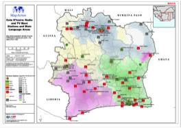
From that training, three maps of the media and telecommunication landscape of Côte d’Ivoire were produced: one that overlays the presence of radio stations onto a map of the location of populations from different language families; one that shows all the radio and TV masts in relation to major language groups; and one representing the mobile phone coverage of a major telecommunication provider.
Better data and information on the impact of disasters and the needs of affected communities is a key element in ensuring the best possible response. However, aid responders very often do not know enough about local media and telecommunication landscapes pre-disaster, which could help them identify which outlets post-disaster might still be functioning and could be best used to reach affected populations. This is a gap in disaster preparedness and response that the infoasaid/MapAction collaboration aims to fill.
This collaboration between MapAction and infoasaid is part of the overall strategy of the infoasaid project that seeks to strengthen the capacity and preparedness of aid agencies to respond to the information and communication needs of disaster affected populations.